Discover and read the best of Twitter Threads about #hurricaneJulia
Most recents (23)
#ExtremeWeather #ClimateChangeNOW update THREAD (ongoing coverage)
While Tropical Storm #Karl is finished, the #ExtremeWeather event associated with #HurricaneJulia and #TSKarl is not yet over.
While Tropical Storm #Karl is finished, the #ExtremeWeather event associated with #HurricaneJulia and #TSKarl is not yet over.
In the animation above you can see the end of #TSKarl #Karl as it, like its parent storm #HurricaneJulia was pushed through the Tehuantepec wind gap into the Gulf of Tehuantepec in the Pacific. 
This animation pics up the story over southern Mexico's Pacific coast this afternoon and evening and shows several convective bursts over land. The one at the end on the bottom left hand side is directly over Acapulco.
[#ExtremeWeather #ClimateChangeNow DATA ANOMALY THREAD – Central & North America]
In this thread I release five sets of data which appear to show atmospheric geo-engineering over North America at unprecedented scale, seemingly for the purpose of keeping hurricanes away.
In this thread I release five sets of data which appear to show atmospheric geo-engineering over North America at unprecedented scale, seemingly for the purpose of keeping hurricanes away.

During observations of #Invest91L #HurricaneJulia & #TSKarl in Central America there was an issue elephant sized mystery in the room – a tangential one, namely what is going on with the Arctic?
The constant impact of a the endless series of arctic blasts on forecasts came particularly obvious when hurricanes in both the Atlantic and Pacific were shown in a forecast moving south in model forecasts.
[#NotYetAHurricaneKarl update Thread, waiting for sunrise ed. #ExtremeWeather #ClimateChangeNow ]
The ridge to the north of #Karl has moved south a fair bit and appears to be pushing #Karl to the south at the eastern edge of the offical NHC Track cone.
The ridge to the north of #Karl has moved south a fair bit and appears to be pushing #Karl to the south at the eastern edge of the offical NHC Track cone.
Here's another view where you can see the leading edge of the ridge that is pushing down on the hurricane capturing it near the entrance to the Tucanpecer's northern funnel.
Lookingclose at the last four hours @NHC_Atlantic may have a point about #NotYetAHurricane #Karl not quite yet being a hurricane - as predicted by the GFS it has collapsed and broadened out close to midnight as the models said.
This IR satelllite image [src: @TropicalTidbits] shows #TSKarl is unquestionably now #HurricaneKarl. It also shows it is not moving towards the Mexico coast line as per the current @NHC_Atlantic forecast - but moving NE. And the transformation into this was 3 hours ago.
Here are its first three hours as a hurricane.
This has to be the most spectacular cyclone genesis ever! The remnants of #HurricaneJulia become (what is most likely) #HurricaneKarl.
Close up view of the last six hours. It looks as if the #TSKarl (soon to be #HurricaneKarl reversed direction again and is heading back north into the shear, and soon the night. It will be interesting to see whether it continues to strengthen and survives the night.
This is a truly extraordinary storm. One for the history books. The role of the separated southern storm (the other part of #HurricaneJulia's remnants cut in half by the Tehuantepecer now over the Pacific which was feeding Karl in making this possible deserves closer examination.
#ClimateChangeNOW late summer update THREAD.
As winter in the north approaches we are roughly halfway to solstice/midwinter. The Sun's angle to the earth is moving south and we are seeing a burst of late cyclone activity in the Atlantic, Pacific and Indian oceans.
As winter in the north approaches we are roughly halfway to solstice/midwinter. The Sun's angle to the earth is moving south and we are seeing a burst of late cyclone activity in the Atlantic, Pacific and Indian oceans.
The ENSO oscilation remains in a strong La Nina position and seems likely to remain so for the forseeable future. Forecast models tend to predict a return to neutral ENSO but they have done so for some time now & the cause (Antarctic ice melt) may not go away. 


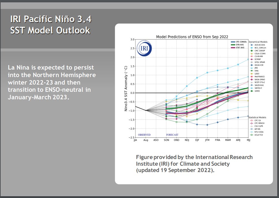


Higher air temperatures globally increase the capacity of the atmosphere to hold water and the consequence is more #ExtrremeWeather rain events causing flooding - recently in West Pacific, Central America, South America, & Indian subcontinent. (see recent 16 day forecasts below) 


[#HurricaneJulia remnants #extremeweather update - ongoing story.]
As expected #TSKarl #Invest93L is being torn apart wind shear over the gulf of Mexico and the Pacific (southern) part of this storm complex is moving rapidly away to the east.
As expected #TSKarl #Invest93L is being torn apart wind shear over the gulf of Mexico and the Pacific (southern) part of this storm complex is moving rapidly away to the east.
The diurnal (night and day) solar energy cycle is playing a big part here so we will need to see what happens whe the sun comes up - a fight back is possible.
However model guidance is consistent that TS #Karl will be blown apart by shear and high pressure moving south.
However model guidance is consistent that TS #Karl will be blown apart by shear and high pressure moving south.
This morning's latest GFS PWAT run shows how this is expected to unfold.
[Ongoing coverage #HurricaneJulia Event #ExtremeWeather #ClimateChangeNow]
At sunrise the remnants of #HurricaneJulia now #Invest93L are developing extremely rapidly over the South Western Gulf of Mexico.
At sunrise the remnants of #HurricaneJulia now #Invest93L are developing extremely rapidly over the South Western Gulf of Mexico.
And the southern #Invest93L remnants of #HurricaneJulia are also developing very rapidly.
Moreover, because of their proximity and positioning the southern storm's outflows are feeding #Invest93L North, which help may explain its spectacular burst of convection on daybreak.
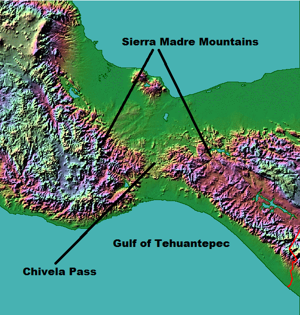
The collision of a Hurricane of the scale of #HurricaneJulia and Tehuantepecer [en.wikipedia.org/wiki/Tehuantep…] wind gap is not something you see everyday, setting the scene phase 2 of the #ExtremeWeather event over Central America. en.wikipedia.org/wiki/Tehuantep….
As you can see in the animation above it as if the storm has been blown up. But in fact it has been split in two - and there are now two components to watch. Potential Hurricane's on both side of the Central American Isthmus.
Left: Eastern Pacific Zone
Right: Atlantic Zone

Left: Eastern Pacific Zone
Right: Atlantic Zone


Here's the first 200 hours of previous run of the GFS model. And at the begin you can see the wind gap event as #HurricaneJulia's Western side came over the Yucutan peninsula pushing a high velocity mass of wet air through the gap.
Cat 1 #HurricaneJulia is now making landfall over Nicaragua, its core covers 3/4 of the Eastern Seaboard and will extreme rainfall is underway over more than 50% of the country already. The scale of the storm is comparable to #HurricaneIAN was at Cat 5 on approach to Florida. 


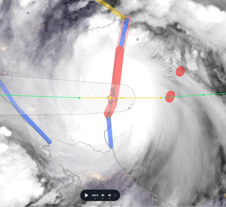


#HurricaneJulia's IR presentation on landfall. The colour gradation represents cloud top temperature with yellow representing the coldest and highest parts of the cyclones structure.
Forecasts expect #HurricaneJulia to decay rapidly, but as it is travelling over very warm rainforested areas with lots of recent rain, and it is dragging in moisture from a very wide area of convection it may maintain more integrity than expected.
#TSJulia's wind and convection area now covers 2.4 million km, draging moisture off the Pacific Ocean over Panama & Costa Rica. Her outer rain bands extend from Colombia to Honduras - and she is not yet a hurricane.
While #TSJulia or #HurricaneJulia is not expected to last much longer, the #ExtremeWeather event associated with the storm is forecast to bring extreme/catastrophic weather across the entire region over the coming fortnight.
Accumulating rainfall forecast - 16 days. GFS Model
Accumulating rainfall forecast - 16 days. GFS Model
Exactly what will happen is far from clear as the forecasts keep changing but the combination of very high atmospheric water, and a massive arctic blast coming south (even pushing a small hurricane backwards down Mexico's Pacific Coast as you see here is not good.
#HurricaneJulia #TSJulia #CentralAmerica #ExtremeWeather.
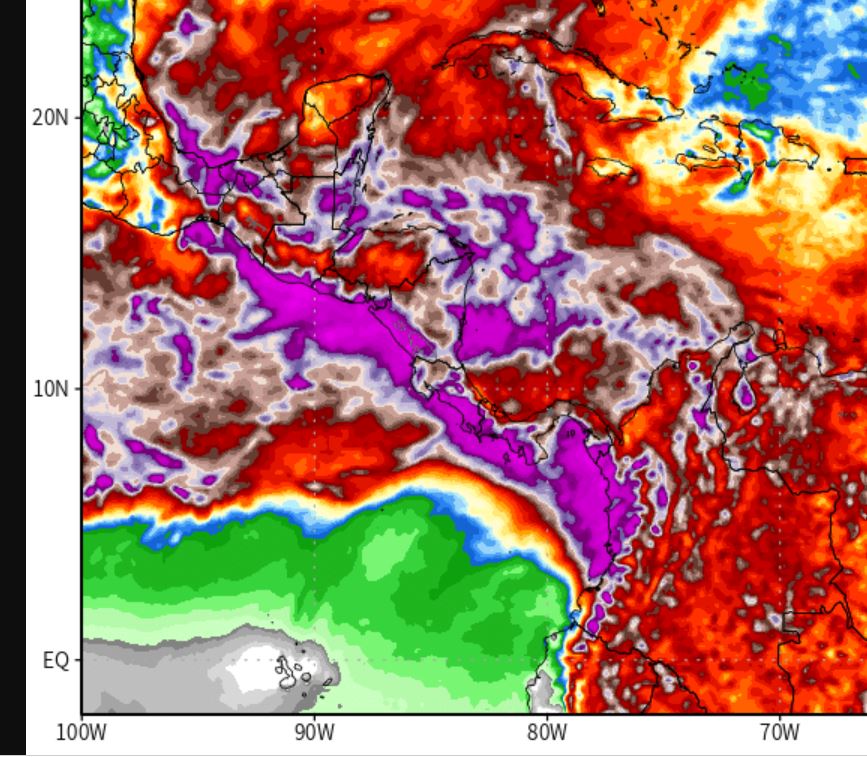
A quick update on the wider #HurricaneJulia long term rainfall prognosis for Central America. Which unfortunately is deteriorating significantly in the latest runs.
Left: 180 Hours
Right:384 Hours

A quick update on the wider #HurricaneJulia long term rainfall prognosis for Central America. Which unfortunately is deteriorating significantly in the latest runs.
Left: 180 Hours
Right:384 Hours


The first week (Hurricane Julia) is bad, but the rains continue for another full week till the end of the forecast period. The next few tweets show how the model picture has evolved.
The full runs are not yet available but we have the first 120 hours - till 13th Oct.
Here's the IWVT (Atmospheric Water Transport/Energy) view - which shows #TSJulia crossing into the Pacific and taking a portion of the saturated atmosphere with her north west up the coast.
Here's the IWVT (Atmospheric Water Transport/Energy) view - which shows #TSJulia crossing into the Pacific and taking a portion of the saturated atmosphere with her north west up the coast.
#ClimateChangeNOW #ExtremeWeather #HurricaneJulia update thread 8-10-22 (late evening CEST)
The possibility Julia may never become a hurricane is clearly on the cards. Her continued divergence (southwards) from the offical track also has signifcant implications r.e. impact.
The possibility Julia may never become a hurricane is clearly on the cards. Her continued divergence (southwards) from the offical track also has signifcant implications r.e. impact.
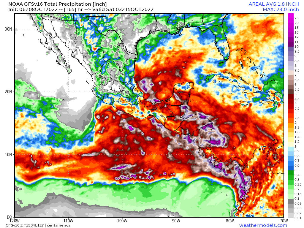
This is illustrated in the latest GFS model run. The full 16 day run is a little implausible but this 165 hours is at least credible.
As you can see here the remnants of Julia cross the isthmus (as discussed in the last update) and then moves deeper into the Pacific.
As you can see here the remnants of Julia cross the isthmus (as discussed in the last update) and then moves deeper into the Pacific.
#ClimateChangeNOW #ExtremeWeather #HurricaneJulia update thread 8-10-22
A lot has changed in the last 12 hours - not so much in the short term but in the longer term model track predictions - and therefore in the outcomes which can be expected for the wider region.
A lot has changed in the last 12 hours - not so much in the short term but in the longer term model track predictions - and therefore in the outcomes which can be expected for the wider region.
Specifically fromthe latest GFS run (and its predecessors) the degree of uncertainty with respect to impacts is increasing. At present Julia is not officially a hurricane and the extent of structure in the 300km wide central area of convection is not known.
Latest GFS Run.
Latest GFS Run.
Future #HurricaneJulia #ExtremeWeather update thread.
Tropical Depression #13L is finally over open water. At 355,000km2 it is a bit bigger than Germany. And it is expected to become a hurricane before arriving in Nicaragua on Sunday. It has already killed at least 8 people.
Tropical Depression #13L is finally over open water. At 355,000km2 it is a bit bigger than Germany. And it is expected to become a hurricane before arriving in Nicaragua on Sunday. It has already killed at least 8 people.

Here is an HRWF model simulation of the storm's path to Nicaragua it is currently expected to arrive there at around 3am local time, but wind and rain will arrive a lot earlier.
Earlier I posted a thread looking a little closer at the expected impact/threadt posed to the 56 million inhabitants of 8 Central American Countries (excluding Mexico) over the next 16 days.
#CentralAmerica #ClimateChangeNOW #ExtremeWeather #HurricaneJulia #IMPACT 16-day assessment THREAD.
It is time to consider what is about to happen in Central America from a #LossAndDamages perspective.
It is time to consider what is about to happen in Central America from a #LossAndDamages perspective.

With less than 72 hours till #HurricaneJulia's expected landfall in Nicaragua, #TD13L #PC13L #Invest91L has already wreaked untold havoc in Venezeula, it is now over Colombia. The death toll is rising.
What is ahead is dangerous. #ExtremeWeather impacts for 200 million souls.

What is ahead is dangerous. #ExtremeWeather impacts for 200 million souls.


#ExtremeWeather Potential Cyclone #PC13L Update Thread.
@NHC_Atlantic is dispatching a second reconnaissance mission to investigate the disturbance off the coast of Venezeula as the storm approaches open water after spending several hours partially over land.
@NHC_Atlantic is dispatching a second reconnaissance mission to investigate the disturbance off the coast of Venezeula as the storm approaches open water after spending several hours partially over land.
@NHC_Atlantic A comprehensive discussion has now been released by @NHC_Atlantic [ nhc.noaa.gov/text/refresh/M…] providing an insight into what the experts expecting from this tropical tropical wave, which has been given a rare "Near 100%" probability of becoming #HurricaneJulia. 

#ExtremeWeather #ClimateChangeNOW thread.
Introducing what is soon to be #HurricaneJulia, presently Potential Cyclone #PC13AL with a rare near 100% probability [per @NHC_Atlantic] of forming.
One of the, if not the, wettest storm in living memory in the Western Hemisphere.
Introducing what is soon to be #HurricaneJulia, presently Potential Cyclone #PC13AL with a rare near 100% probability [per @NHC_Atlantic] of forming.
One of the, if not the, wettest storm in living memory in the Western Hemisphere.

@NHC_Atlantic At present the GFS shows #HurricaneJulia making formal landfall at 6am local time Sunday, with modest winds for a hurricane. Heavy, flood and slip causing rains however will arrive well ahead of landfall and by midday Sunday the center of the storm will cover all of Nicaragua. 


Large storms of this kind are very dangerous from a flooding perspective as the rain will be persistent for a long time. This is a seven day ECMWF model rain forecast Nicaragua and Honduras it gives rough idea of how much rain may fall. I.E. a lot - continuously, everywhere.
My premature assumption on this was so very very wrong. I missed the big picture. Once it gets organised after sun rise this entire 2.8 million km2 complex of storms is moving west together, orchestrated by the #PC13L tropical wave/disturbance.
Its a huge gyre over land.
Its a huge gyre over land.
It becomes a bit clearer as you zoom out and speed it up. This animation is 24 hours.
#Invest91AL #PC91AL #HurricaneJulia Regional View 24h animation ~ @Zoom_Earth
A tropical wave embedded in a tropical belt surge of atmospheric water vapour, over the Amazon, the lungs of the earth.
A tropical wave embedded in a tropical belt surge of atmospheric water vapour, over the Amazon, the lungs of the earth.
Latest visual #RAMMB Imagery of #Invest91L #PC13L #Hurricanejulia
Its definitely alive and well and battling with the land space and on the NW track. Not yet cohesive and moving rapidly.
Its leading edge is approaching Aruba.
Its definitely alive and well and battling with the land space and on the NW track. Not yet cohesive and moving rapidly.
Its leading edge is approaching Aruba.
1. A large part of the storm is now over land. But that does not appear to be bothering it too much.
2. When looked at from a zoomed out perspective the "pinecone" shape of the storm has returned.
#PC13L #INVEST91L #HURRICANEJULIA

2. When looked at from a zoomed out perspective the "pinecone" shape of the storm has returned.
#PC13L #INVEST91L #HURRICANEJULIA


This #RAAMB microwave imagery shows a circular feature, the majority of which is over land. I'm guessing this is a tool to identify the center under all the cloud.
If so then the center should be back over clear water fairly soon.
If so then the center should be back over clear water fairly soon.

Has #Invest91L become a hurricane yet?
Quoted thread looks at satellite/radar data sources.
Unfortunately the GOES East Floater Satellite data which would confirm this is not publicly accessible as far as I can tell - except via CMISS [link>> tropic.ssec.wisc.edu/#]
Quoted thread looks at satellite/radar data sources.
Unfortunately the GOES East Floater Satellite data which would confirm this is not publicly accessible as far as I can tell - except via CMISS [link>> tropic.ssec.wisc.edu/#]
This thread contains CMISS animations as it is the most conclusive. First the visible 1km floater image at sunrise.
#Invest91L appears to now have a hurricane like structure. The first image from CMISS appears to be newer than the the Second & 3rd one from GOES East. 


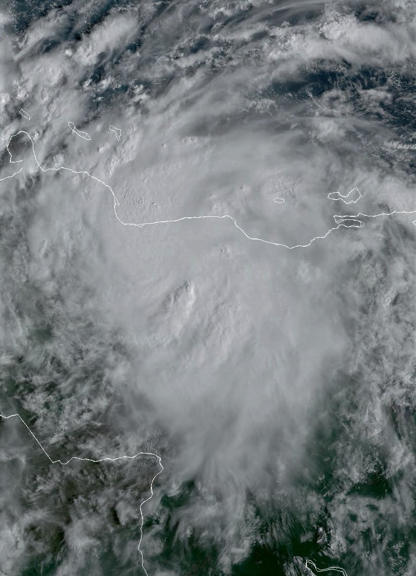
This definitely looks like #HurricaneJulia. She has an eye and a perfectly symetrical form & outflows.
& from @zoom_earth
If this is a #hurricaneJulia it is moving very fast. Possibly too fast. Extrapolating the speed from the time stamps I get 88kmh or 47 knots. Possibly too fast?
It could a pre-cylone-genesis vortex perhaps?
If this is a #hurricaneJulia it is moving very fast. Possibly too fast. Extrapolating the speed from the time stamps I get 88kmh or 47 knots. Possibly too fast?
It could a pre-cylone-genesis vortex perhaps?
#HurricaneIAN is finally leaving the United States.
Meanwhile "diturbance" #Invest91L - which may soon become #HurricaneJulia - has taken on the appearance of a comet. 

#Invest91L at sunset 5th October 2022


