Discover and read the best of Twitter Threads about #TSJulia
Most recents (3)
#TSJulia's wind and convection area now covers 2.4 million km, draging moisture off the Pacific Ocean over Panama & Costa Rica. Her outer rain bands extend from Colombia to Honduras - and she is not yet a hurricane.
While #TSJulia or #HurricaneJulia is not expected to last much longer, the #ExtremeWeather event associated with the storm is forecast to bring extreme/catastrophic weather across the entire region over the coming fortnight.
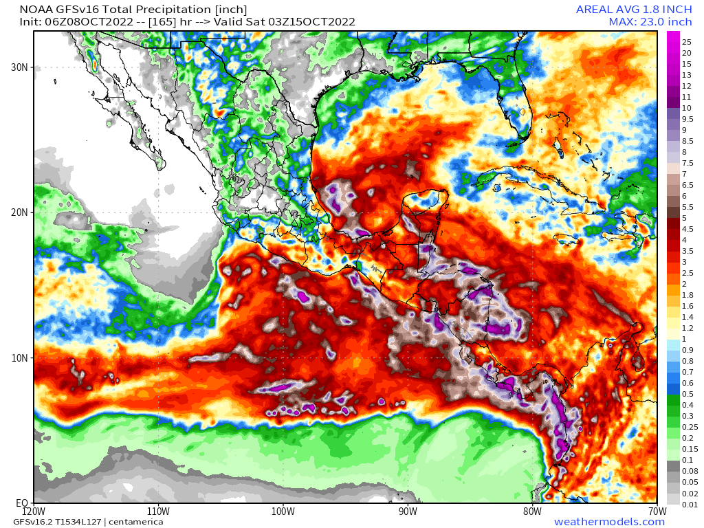
Accumulating rainfall forecast - 16 days. GFS Model
Accumulating rainfall forecast - 16 days. GFS Model
Exactly what will happen is far from clear as the forecasts keep changing but the combination of very high atmospheric water, and a massive arctic blast coming south (even pushing a small hurricane backwards down Mexico's Pacific Coast as you see here is not good.
#HurricaneJulia #TSJulia #CentralAmerica #ExtremeWeather.
A quick update on the wider #HurricaneJulia long term rainfall prognosis for Central America. Which unfortunately is deteriorating significantly in the latest runs.
Left: 180 Hours
Right:384 Hours

A quick update on the wider #HurricaneJulia long term rainfall prognosis for Central America. Which unfortunately is deteriorating significantly in the latest runs.
Left: 180 Hours
Right:384 Hours


The first week (Hurricane Julia) is bad, but the rains continue for another full week till the end of the forecast period. The next few tweets show how the model picture has evolved.
The full runs are not yet available but we have the first 120 hours - till 13th Oct.
Here's the IWVT (Atmospheric Water Transport/Energy) view - which shows #TSJulia crossing into the Pacific and taking a portion of the saturated atmosphere with her north west up the coast.
Here's the IWVT (Atmospheric Water Transport/Energy) view - which shows #TSJulia crossing into the Pacific and taking a portion of the saturated atmosphere with her north west up the coast.
#ClimateChangeNOW #ExtremeWeather #HurricaneJulia update thread 8-10-22 (late evening CEST)
The possibility Julia may never become a hurricane is clearly on the cards. Her continued divergence (southwards) from the offical track also has signifcant implications r.e. impact.
The possibility Julia may never become a hurricane is clearly on the cards. Her continued divergence (southwards) from the offical track also has signifcant implications r.e. impact.
This is illustrated in the latest GFS model run. The full 16 day run is a little implausible but this 165 hours is at least credible.
As you can see here the remnants of Julia cross the isthmus (as discussed in the last update) and then moves deeper into the Pacific.
As you can see here the remnants of Julia cross the isthmus (as discussed in the last update) and then moves deeper into the Pacific.


