Discover and read the best of Twitter Threads about #extremeweather
Most recents (24)
This #ExtremeWeather tweet did not age well.
The very slow moving #Biparjoy continues to advance well inland into Ragastan and remains very much a threat to over land - which was the problem with the (in many ways) similar Pakistan storm in June 2022. Which is ominous and… twitter.com/i/web/status/1…
The very slow moving #Biparjoy continues to advance well inland into Ragastan and remains very much a threat to over land - which was the problem with the (in many ways) similar Pakistan storm in June 2022. Which is ominous and… twitter.com/i/web/status/1…
L-R Biparjoy (Western India) O3B (Bangladesh) and Guchol are lined up on the same latitude - and this probably explains why.
O3B - the one off the coast of Bangladesh was fairly short lived, but still strong enough to seed significant water vapour into the atmosphere which was… twitter.com/i/web/status/1…
O3B - the one off the coast of Bangladesh was fairly short lived, but still strong enough to seed significant water vapour into the atmosphere which was… twitter.com/i/web/status/1…
Meanwhile #CycloneBiparjoy West was still going strong last night - long after it was expected to dissappate, probably due to it being fed by Westerly winds full of water vapour.
This cyclone originated in the same place as the Pakistan cyclone. Which was also powered by… twitter.com/i/web/status/1…
This cyclone originated in the same place as the Pakistan cyclone. Which was also powered by… twitter.com/i/web/status/1…
1/5 Rising temps in the North Atlantic are more than just a climate change indicator - they pose real threats to human life. Let’s talk about why. #ClimateChange #NorthAtlantic
2/5 First, warmer waters can fuel more intense storms and hurricanes, increasing risks for coastal communities globally. This means higher potential for loss of life and property damage. #ExtremeWeather
3/5 Second, thermal expansion from warmer waters contributes to sea level rise. This could lead to increased coastal erosion and flooding, displacing people from their homes and affecting livelihoods. #SeaLevelRise
10 reasons to why everyone wants to study/ relocate in USA and why you should think twice before doing the same...
Ever heard of the "AMERICAN DREAM?" this is why you shouldn’t dream that dream
Thread, Please RT
Ever heard of the "AMERICAN DREAM?" this is why you shouldn’t dream that dream
Thread, Please RT

1/🌎 The "American Dream": The USA's reputation as a land of opportunity has attracted countless people worldwide. But keep in mind, achieving success often requires hard work, dedication, and perseverance. Success isn't guaranteed! #AmericanDream
If we put "the American dream" aside @tassaa99 can still assist you to study in USA. DM us and one of our staff will get back to you with all details or click the link below
wa.me/message/IBHOV7…
wa.me/message/IBHOV7…
For comparison - here (quoted tweet) is last year's thread,There are lots of similarities with observable weather patterns & model forecasts as the two threads pertain to a similar state of the global energy balance.


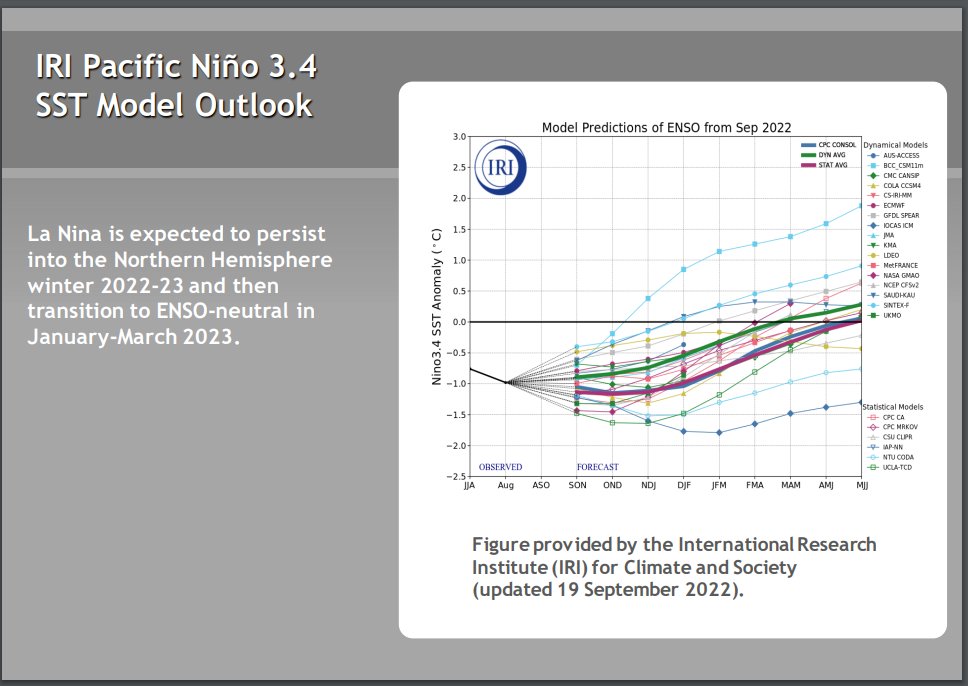
The most notable differemce with the 2023 Equinox is that ENSO (the La Nina/El Nino oscillation) is moving into neutral which could result in a reduction of tropical convection and therefore less precipitation. However that is not yet cpc.ncep.noaa.gov/products/analy…… twitter.com/i/web/status/1… 


Today, @CountyofTulare will vote on its local hazard mitigation plan—a plan that fails to identify key vulnerabilities and address residents’ concerns in the wake of recent storms and flooding throughout the County. 

As temperatures continue to rise, water sources become depleted, and #extremeweather events become more common, vulnerable communities will face the harsh reality of years of disinvestment and scarcity of resources to mitigate impacts and build climate resilience.
The @CountyofTulare local hazard mitigation plan fails to comply with SB 379 by not conducting a vulnerability assessment or identifying vulnerable communities. As a result, the County is not adequately prepared for addressing the impacts of #climatechange.
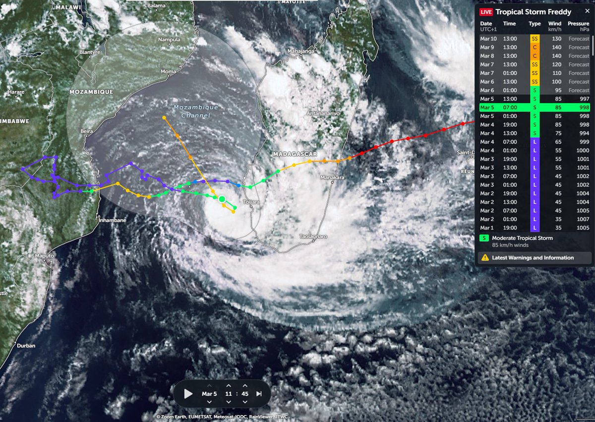
Here's an earlier vioew from theis morning while the spinning up cyclone - now commencing its second pass across the Mozambique Channel started intensifying rapidly, very quickly developing a clear eye.
Here's a 24h animation over night and into this morning.
#ExtremeWeather #Mozambique #Madagascar #Zimbabwe UPDATE THREAD
The Cyclone Freddy event which initiated a humanitarian emergency in South East Africa (exacerbating exisiting folldinghas now been underway for a fortnight and is ongoing. Freddy is expected to strengthen and… twitter.com/i/web/status/1…
The Cyclone Freddy event which initiated a humanitarian emergency in South East Africa (exacerbating exisiting folldinghas now been underway for a fortnight and is ongoing. Freddy is expected to strengthen and… twitter.com/i/web/status/1…

The quoted tweet in the OP above covers the period February 21-27.
This thread provides an update series of 24 hour satellite animations from 27th Feb till March 5th. But the event is not yet over. The latest UNHCR emergency reponse reliefweb.int/report/mozambi…… twitter.com/i/web/status/1…
This thread provides an update series of 24 hour satellite animations from 27th Feb till March 5th. But the event is not yet over. The latest UNHCR emergency reponse reliefweb.int/report/mozambi…… twitter.com/i/web/status/1…
So far 1.75 million people have been affected - and 163,000 were affected as of March 3rd - when this [reliefweb.int/report/mozambi…[ report (the most recent) was issued. 


Why is fixed Uranus most hazardous at the mid degrees?
Because 15 fixed is the midpoint of the zero degrees cardinal sign seasonal markers [ where element energies [fire-water water-air air-earth earth-fire are in a balancing process]
#ExtremeWeather
#astrometeorology
🧵
Because 15 fixed is the midpoint of the zero degrees cardinal sign seasonal markers [ where element energies [fire-water water-air air-earth earth-fire are in a balancing process]
#ExtremeWeather
#astrometeorology
🧵

2.
The period start of Dec '22 to mid March '23 shows extemely little movement in URA: holding just one degree range 15-16♉️
Major earthquakes landslips & cyclones began to accumulate during Feb with URA holding stationing just minutes from exact 15 degrees since Jan 22nd
The period start of Dec '22 to mid March '23 shows extemely little movement in URA: holding just one degree range 15-16♉️
Major earthquakes landslips & cyclones began to accumulate during Feb with URA holding stationing just minutes from exact 15 degrees since Jan 22nd
3.
Extremely slow moving Uranus at this angle to the cardinal axes disturbs the balancing processes in the atmosphere & environment -relative to the paired elements signalled by the zodiac signs on the axes
Extremely slow moving Uranus at this angle to the cardinal axes disturbs the balancing processes in the atmosphere & environment -relative to the paired elements signalled by the zodiac signs on the axes
#COP27 | #LossAndDamage
In the first half of 2022, developing countries suffered USD26.2 bn economic losses, while just 6 #FossilFuel companies reported a profit of USD95 bn, finds @LossandDamage's latest report.
@MongabayIndia @mongabay cc @theplainjain
india.mongabay.com/2022/10/explai…
In the first half of 2022, developing countries suffered USD26.2 bn economic losses, while just 6 #FossilFuel companies reported a profit of USD95 bn, finds @LossandDamage's latest report.
@MongabayIndia @mongabay cc @theplainjain
india.mongabay.com/2022/10/explai…
Rich, industrialised countries have contributed an estimated 92% of excess historical emissions, yet it is the developing & vulnerable countries that are hit the hardest by climate change impacts.
oxfam.org/en/research/fo…
oxfam.org/en/research/fo…
Experts tag #COP27 as the 1st climate summit in “the era of #LossAndDamage.”
In 2022, over 119 record-breaking #ExtremeWeather events hit developing countries, resulting in billions of dollars of losses.
In 2022, over 119 record-breaking #ExtremeWeather events hit developing countries, resulting in billions of dollars of losses.
[Ongoing #Vietnam #SthChina #ExtremeWeather Update thread Typhoon #NenengPH]
Image source @NASA #WorldView. [link >> worldview.earthdata.nasa.gov/?v=64.78263600…]
Image source @NASA #WorldView. [link >> worldview.earthdata.nasa.gov/?v=64.78263600…]

Presently a Cat 2 Typhoon #Nesat/#NenengPH is another massive late season storm forecast to make landfall on Oct 20th in the Gulf of Tonkin south of Hanoi and weaken to a Tropical Storm before doing so. the South China Island of Hainan will likely receive the worst of the storm. 

Unfortunately the @zoom_earth Hinmawari Satellite imagery is not available. But from the weather radar data we can see that intense rain bands are now coming ashore on the east coast of Hainan, possibly accompanied by hurricane force winds. 

[#CentralAmerica #ExtremeWeather #ClimateChangeNOW update THREAD (ongoing coverage - initiated October 2 - storms #Julia #Karl]
With #Karl now dissapated the next disturbance has now been designated by @NHC_Atlantic.


With #Karl now dissapated the next disturbance has now been designated by @NHC_Atlantic.


The situation remains complex and unpredictable with many significant variables at play which could alter the outcome. The latest complete GFS run shows the next hurricane landfalling in Mexico 24 Oct. & remnants forming into a Gulf cyclone on 26 Oct.
[#ExtremeWeather #ClimateChangeNow coverage initiation THREAD].
The next potentially devastating northern hemisphere hurrricane candidate #92B has now been designated.


The next potentially devastating northern hemisphere hurrricane candidate #92B has now been designated.


The potential new storm - which is modeled to head north into the Bay of Bengal in coming days and make - has been in global simulation models for several days. This is the latest GFS3 IWVT model run.
#Invest92b #92b GFS3 Model 16 day forecast of precipititable water (PWAT)
With a series of West Pacific tropical storms & typhoons - including #NenengPH [which you can see arriving in Vietnam shortly on upper right] - the Nth. Indian ocean is flooded with water vapour.
With a series of West Pacific tropical storms & typhoons - including #NenengPH [which you can see arriving in Vietnam shortly on upper right] - the Nth. Indian ocean is flooded with water vapour.
#ExtremeWeather #ClimateChangeNOW update THREAD (ongoing coverage)
While Tropical Storm #Karl is finished, the #ExtremeWeather event associated with #HurricaneJulia and #TSKarl is not yet over.
While Tropical Storm #Karl is finished, the #ExtremeWeather event associated with #HurricaneJulia and #TSKarl is not yet over.
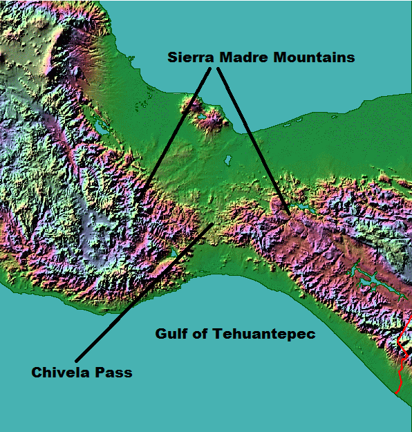
In the animation above you can see the end of #TSKarl #Karl as it, like its parent storm #HurricaneJulia was pushed through the Tehuantepec wind gap into the Gulf of Tehuantepec in the Pacific. 

This animation pics up the story over southern Mexico's Pacific coast this afternoon and evening and shows several convective bursts over land. The one at the end on the bottom left hand side is directly over Acapulco.
[#ExtremeWeather #ClimateChangeNow DATA ANOMALY THREAD – Central & North America]
In this thread I release five sets of data which appear to show atmospheric geo-engineering over North America at unprecedented scale, seemingly for the purpose of keeping hurricanes away.
In this thread I release five sets of data which appear to show atmospheric geo-engineering over North America at unprecedented scale, seemingly for the purpose of keeping hurricanes away.

During observations of #Invest91L #HurricaneJulia & #TSKarl in Central America there was an issue elephant sized mystery in the room – a tangential one, namely what is going on with the Arctic?
The constant impact of a the endless series of arctic blasts on forecasts came particularly obvious when hurricanes in both the Atlantic and Pacific were shown in a forecast moving south in model forecasts.
#CentralAmerica #ExtremeWeather update thread.
Sunrise over #Karl is imminent. Its going to be another interesting day I think.
Sunrise over #Karl is imminent. Its going to be another interesting day I think.

[#NotYetAHurricaneKarl update Thread, waiting for sunrise ed. #ExtremeWeather #ClimateChangeNow ]
The ridge to the north of #Karl has moved south a fair bit and appears to be pushing #Karl to the south at the eastern edge of the offical NHC Track cone.
The ridge to the north of #Karl has moved south a fair bit and appears to be pushing #Karl to the south at the eastern edge of the offical NHC Track cone.
Here's another view where you can see the leading edge of the ridge that is pushing down on the hurricane capturing it near the entrance to the Tucanpecer's northern funnel.
Lookingclose at the last four hours @NHC_Atlantic may have a point about #NotYetAHurricane #Karl not quite yet being a hurricane - as predicted by the GFS it has collapsed and broadened out close to midnight as the models said.
#ClimateChangeNOW late summer update THREAD.
As winter in the north approaches we are roughly halfway to solstice/midwinter. The Sun's angle to the earth is moving south and we are seeing a burst of late cyclone activity in the Atlantic, Pacific and Indian oceans.
As winter in the north approaches we are roughly halfway to solstice/midwinter. The Sun's angle to the earth is moving south and we are seeing a burst of late cyclone activity in the Atlantic, Pacific and Indian oceans.
The ENSO oscilation remains in a strong La Nina position and seems likely to remain so for the forseeable future. Forecast models tend to predict a return to neutral ENSO but they have done so for some time now & the cause (Antarctic ice melt) may not go away. 


Higher air temperatures globally increase the capacity of the atmosphere to hold water and the consequence is more #ExtrremeWeather rain events causing flooding - recently in West Pacific, Central America, South America, & Indian subcontinent. (see recent 16 day forecasts below) 


[#HurricaneJulia remnants #extremeweather update - ongoing story.]
As expected #TSKarl #Invest93L is being torn apart wind shear over the gulf of Mexico and the Pacific (southern) part of this storm complex is moving rapidly away to the east.
As expected #TSKarl #Invest93L is being torn apart wind shear over the gulf of Mexico and the Pacific (southern) part of this storm complex is moving rapidly away to the east.
The diurnal (night and day) solar energy cycle is playing a big part here so we will need to see what happens whe the sun comes up - a fight back is possible.
However model guidance is consistent that TS #Karl will be blown apart by shear and high pressure moving south.
However model guidance is consistent that TS #Karl will be blown apart by shear and high pressure moving south.
This morning's latest GFS PWAT run shows how this is expected to unfold.
[Ongoing coverage #HurricaneJulia Event #ExtremeWeather #ClimateChangeNow]
At sunrise the remnants of #HurricaneJulia now #Invest93L are developing extremely rapidly over the South Western Gulf of Mexico.
At sunrise the remnants of #HurricaneJulia now #Invest93L are developing extremely rapidly over the South Western Gulf of Mexico.
And the southern #Invest93L remnants of #HurricaneJulia are also developing very rapidly.
Moreover, because of their proximity and positioning the southern storm's outflows are feeding #Invest93L North, which help may explain its spectacular burst of convection on daybreak.
The collision of a Hurricane of the scale of #HurricaneJulia and Tehuantepecer [en.wikipedia.org/wiki/Tehuantep…] wind gap is not something you see everyday, setting the scene phase 2 of the #ExtremeWeather event over Central America. en.wikipedia.org/wiki/Tehuantep….
As you can see in the animation above it as if the storm has been blown up. But in fact it has been split in two - and there are now two components to watch. Potential Hurricane's on both side of the Central American Isthmus.
Left: Eastern Pacific Zone
Right: Atlantic Zone

Left: Eastern Pacific Zone
Right: Atlantic Zone


Here's the first 200 hours of previous run of the GFS model. And at the begin you can see the wind gap event as #HurricaneJulia's Western side came over the Yucutan peninsula pushing a high velocity mass of wet air through the gap.
#TSJulia's wind and convection area now covers 2.4 million km, draging moisture off the Pacific Ocean over Panama & Costa Rica. Her outer rain bands extend from Colombia to Honduras - and she is not yet a hurricane.
While #TSJulia or #HurricaneJulia is not expected to last much longer, the #ExtremeWeather event associated with the storm is forecast to bring extreme/catastrophic weather across the entire region over the coming fortnight.
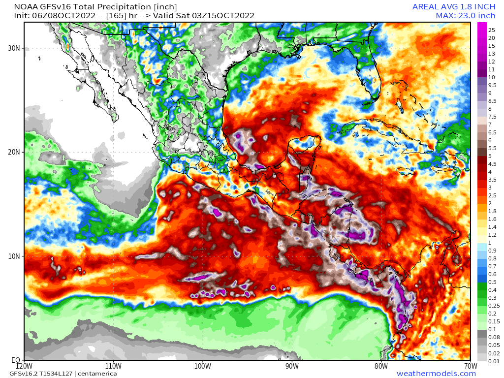
Accumulating rainfall forecast - 16 days. GFS Model
Accumulating rainfall forecast - 16 days. GFS Model
Exactly what will happen is far from clear as the forecasts keep changing but the combination of very high atmospheric water, and a massive arctic blast coming south (even pushing a small hurricane backwards down Mexico's Pacific Coast as you see here is not good.
#HurricaneJulia #TSJulia #CentralAmerica #ExtremeWeather.
A quick update on the wider #HurricaneJulia long term rainfall prognosis for Central America. Which unfortunately is deteriorating significantly in the latest runs.
Left: 180 Hours
Right:384 Hours

A quick update on the wider #HurricaneJulia long term rainfall prognosis for Central America. Which unfortunately is deteriorating significantly in the latest runs.
Left: 180 Hours
Right:384 Hours


The first week (Hurricane Julia) is bad, but the rains continue for another full week till the end of the forecast period. The next few tweets show how the model picture has evolved.
The full runs are not yet available but we have the first 120 hours - till 13th Oct.
Here's the IWVT (Atmospheric Water Transport/Energy) view - which shows #TSJulia crossing into the Pacific and taking a portion of the saturated atmosphere with her north west up the coast.
Here's the IWVT (Atmospheric Water Transport/Energy) view - which shows #TSJulia crossing into the Pacific and taking a portion of the saturated atmosphere with her north west up the coast.
#ClimateChangeNOW #ExtremeWeather #HurricaneJulia update thread 8-10-22 (late evening CEST)
The possibility Julia may never become a hurricane is clearly on the cards. Her continued divergence (southwards) from the offical track also has signifcant implications r.e. impact.
The possibility Julia may never become a hurricane is clearly on the cards. Her continued divergence (southwards) from the offical track also has signifcant implications r.e. impact.
This is illustrated in the latest GFS model run. The full 16 day run is a little implausible but this 165 hours is at least credible.
As you can see here the remnants of Julia cross the isthmus (as discussed in the last update) and then moves deeper into the Pacific.
As you can see here the remnants of Julia cross the isthmus (as discussed in the last update) and then moves deeper into the Pacific.
#ClimateChangeNOW #ExtremeWeather #HurricaneJulia update thread 8-10-22
A lot has changed in the last 12 hours - not so much in the short term but in the longer term model track predictions - and therefore in the outcomes which can be expected for the wider region.
A lot has changed in the last 12 hours - not so much in the short term but in the longer term model track predictions - and therefore in the outcomes which can be expected for the wider region.
Specifically fromthe latest GFS run (and its predecessors) the degree of uncertainty with respect to impacts is increasing. At present Julia is not officially a hurricane and the extent of structure in the 300km wide central area of convection is not known.
Latest GFS Run.
Latest GFS Run.


