Discover and read the best of Twitter Threads about #TSKarl
Most recents (12)
[#CentralAmerica #ExtremeWeather #ClimateChangeNOW update THREAD (ongoing coverage - initiated October 2 - storms #Julia #Karl]
With #Karl now dissapated the next disturbance has now been designated by @NHC_Atlantic.


With #Karl now dissapated the next disturbance has now been designated by @NHC_Atlantic.


The situation remains complex and unpredictable with many significant variables at play which could alter the outcome. The latest complete GFS run shows the next hurricane landfalling in Mexico 24 Oct. & remnants forming into a Gulf cyclone on 26 Oct.
#ExtremeWeather #ClimateChangeNOW update THREAD (ongoing coverage)
While Tropical Storm #Karl is finished, the #ExtremeWeather event associated with #HurricaneJulia and #TSKarl is not yet over.
While Tropical Storm #Karl is finished, the #ExtremeWeather event associated with #HurricaneJulia and #TSKarl is not yet over.
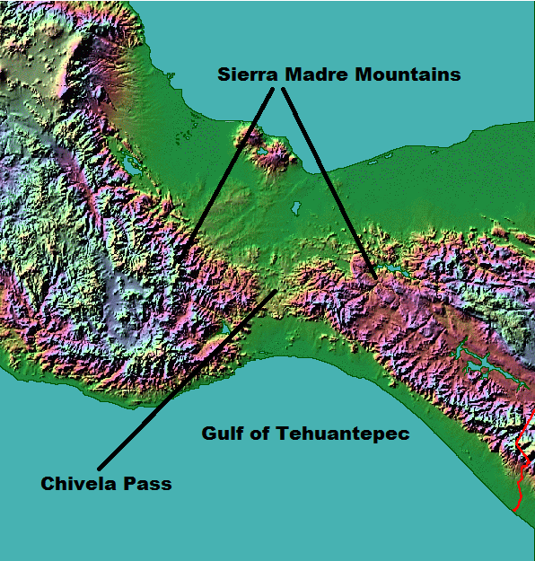
In the animation above you can see the end of #TSKarl #Karl as it, like its parent storm #HurricaneJulia was pushed through the Tehuantepec wind gap into the Gulf of Tehuantepec in the Pacific. 

This animation pics up the story over southern Mexico's Pacific coast this afternoon and evening and shows several convective bursts over land. The one at the end on the bottom left hand side is directly over Acapulco.
#TSKarl vs the Tehuantepecer
GFS3's latest prognostications on the Karl vs the Tehuantepecer battle. Karl gets shoved through the Tehuantepecer wind gap by an arctic blast, and then it all happens again....
.. and then a strong wind blows in from the North followed by an even stronger wind from the East that curls up through the Tehuantepecer wind gap, and whips a hurricane up over Mexico City, on a positive side it also, mercifully, blows away a lot of the rain clouds.
[#ExtremeWeather #ClimateChangeNow DATA ANOMALY THREAD – Central & North America]
In this thread I release five sets of data which appear to show atmospheric geo-engineering over North America at unprecedented scale, seemingly for the purpose of keeping hurricanes away.
In this thread I release five sets of data which appear to show atmospheric geo-engineering over North America at unprecedented scale, seemingly for the purpose of keeping hurricanes away.

During observations of #Invest91L #HurricaneJulia & #TSKarl in Central America there was an issue elephant sized mystery in the room – a tangential one, namely what is going on with the Arctic?
The constant impact of a the endless series of arctic blasts on forecasts came particularly obvious when hurricanes in both the Atlantic and Pacific were shown in a forecast moving south in model forecasts.
#CentralAmerica #ExtremeWeather update thread.
Sunrise over #Karl is imminent. Its going to be another interesting day I think.
Sunrise over #Karl is imminent. Its going to be another interesting day I think.

And now, finally, @NHC_Atlantic has put up a new advisory on #TSKarl #HurricaneKarl
...AIR FORCE RESERVE HURRICANE HUNTERS INVESTIGATING KARL...
...AIR FORCE RESERVE HURRICANE HUNTERS INVESTIGATING KARL...

Current satellite imagery shows why NHC thinks Karl will also be pushed through the Tehuantepecer wind gap for a 2nd time - its all a matter of timing. Karl is already clearly outside their cone, the railway lines show where a ridge is building as dry air pushes south. 


You can see the scenario in the latest GFS model here. But bear in mind that this is based on the assumption that Karl is still a tropical storm. And as you can see it is expected to decay very rapidly over night.
Its now pretty clear what is going on. #HurricaneKarl #TSKarl is caught in an atmospheric river generated by #TD99E (in a similar way to how #HurricaneIan was) and headed towards florida - not Mexico.
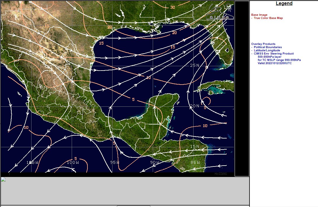
The second overlay is a special "steering" product that allows you to see where a cyclone is headed - it focusses on the 500-850hpa wind range (1.5 to 5.5kms high winds ) which are particularly important for pushing cyclones. 

And as you can see #HurricaneKarl is being steered towards northern Florida at present.
This IR satelllite image [src: @TropicalTidbits] shows #TSKarl is unquestionably now #HurricaneKarl. It also shows it is not moving towards the Mexico coast line as per the current @NHC_Atlantic forecast - but moving NE. And the transformation into this was 3 hours ago.
Here are its first three hours as a hurricane.
This has to be the most spectacular cyclone genesis ever! The remnants of #HurricaneJulia become (what is most likely) #HurricaneKarl.
Close up view of the last six hours. It looks as if the #TSKarl (soon to be #HurricaneKarl reversed direction again and is heading back north into the shear, and soon the night. It will be interesting to see whether it continues to strengthen and survives the night.
This is a truly extraordinary storm. One for the history books. The role of the separated southern storm (the other part of #HurricaneJulia's remnants cut in half by the Tehuantepecer now over the Pacific which was feeding Karl in making this possible deserves closer examination.
#ClimateChangeNOW late summer update THREAD.
As winter in the north approaches we are roughly halfway to solstice/midwinter. The Sun's angle to the earth is moving south and we are seeing a burst of late cyclone activity in the Atlantic, Pacific and Indian oceans.
As winter in the north approaches we are roughly halfway to solstice/midwinter. The Sun's angle to the earth is moving south and we are seeing a burst of late cyclone activity in the Atlantic, Pacific and Indian oceans.
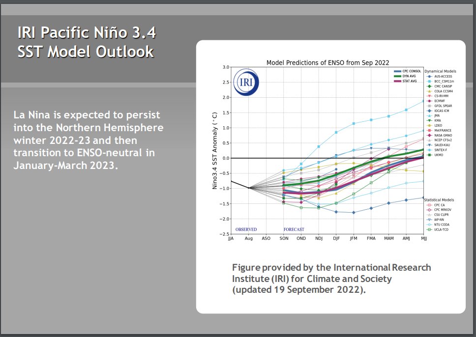
The ENSO oscilation remains in a strong La Nina position and seems likely to remain so for the forseeable future. Forecast models tend to predict a return to neutral ENSO but they have done so for some time now & the cause (Antarctic ice melt) may not go away. 


Higher air temperatures globally increase the capacity of the atmosphere to hold water and the consequence is more #ExtrremeWeather rain events causing flooding - recently in West Pacific, Central America, South America, & Indian subcontinent. (see recent 16 day forecasts below) 


[#HurricaneJulia remnants #extremeweather update - ongoing story.]
As expected #TSKarl #Invest93L is being torn apart wind shear over the gulf of Mexico and the Pacific (southern) part of this storm complex is moving rapidly away to the east.
As expected #TSKarl #Invest93L is being torn apart wind shear over the gulf of Mexico and the Pacific (southern) part of this storm complex is moving rapidly away to the east.
The diurnal (night and day) solar energy cycle is playing a big part here so we will need to see what happens whe the sun comes up - a fight back is possible.
However model guidance is consistent that TS #Karl will be blown apart by shear and high pressure moving south.
However model guidance is consistent that TS #Karl will be blown apart by shear and high pressure moving south.
This morning's latest GFS PWAT run shows how this is expected to unfold.


