Discover and read the best of Twitter Threads about #Invest91L
Most recents (14)
[#ExtremeWeather #ClimateChangeNow DATA ANOMALY THREAD – Central & North America]
In this thread I release five sets of data which appear to show atmospheric geo-engineering over North America at unprecedented scale, seemingly for the purpose of keeping hurricanes away.
In this thread I release five sets of data which appear to show atmospheric geo-engineering over North America at unprecedented scale, seemingly for the purpose of keeping hurricanes away.

During observations of #Invest91L #HurricaneJulia & #TSKarl in Central America there was an issue elephant sized mystery in the room – a tangential one, namely what is going on with the Arctic?
The constant impact of a the endless series of arctic blasts on forecasts came particularly obvious when hurricanes in both the Atlantic and Pacific were shown in a forecast moving south in model forecasts.
[#NotYetAHurricaneKarl update Thread, waiting for sunrise ed. #ExtremeWeather #ClimateChangeNow ]
The ridge to the north of #Karl has moved south a fair bit and appears to be pushing #Karl to the south at the eastern edge of the offical NHC Track cone.
The ridge to the north of #Karl has moved south a fair bit and appears to be pushing #Karl to the south at the eastern edge of the offical NHC Track cone.
Here's another view where you can see the leading edge of the ridge that is pushing down on the hurricane capturing it near the entrance to the Tucanpecer's northern funnel.
Lookingclose at the last four hours @NHC_Atlantic may have a point about #NotYetAHurricane #Karl not quite yet being a hurricane - as predicted by the GFS it has collapsed and broadened out close to midnight as the models said.
#CentralAmerica #ClimateChangeNOW #ExtremeWeather #HurricaneJulia #IMPACT 16-day assessment THREAD.
It is time to consider what is about to happen in Central America from a #LossAndDamages perspective.
It is time to consider what is about to happen in Central America from a #LossAndDamages perspective.

With less than 72 hours till #HurricaneJulia's expected landfall in Nicaragua, #TD13L #PC13L #Invest91L has already wreaked untold havoc in Venezeula, it is now over Colombia. The death toll is rising.
What is ahead is dangerous. #ExtremeWeather impacts for 200 million souls.

What is ahead is dangerous. #ExtremeWeather impacts for 200 million souls.


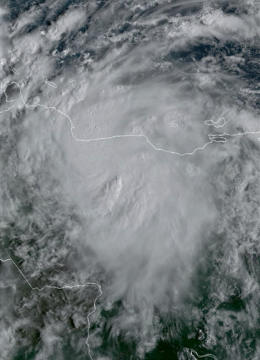
Latest visual #RAMMB Imagery of #Invest91L #PC13L #Hurricanejulia
Its definitely alive and well and battling with the land space and on the NW track. Not yet cohesive and moving rapidly.
Its leading edge is approaching Aruba.
Its definitely alive and well and battling with the land space and on the NW track. Not yet cohesive and moving rapidly.
Its leading edge is approaching Aruba.
1. A large part of the storm is now over land. But that does not appear to be bothering it too much.
2. When looked at from a zoomed out perspective the "pinecone" shape of the storm has returned.
#PC13L #INVEST91L #HURRICANEJULIA

2. When looked at from a zoomed out perspective the "pinecone" shape of the storm has returned.
#PC13L #INVEST91L #HURRICANEJULIA


This #RAAMB microwave imagery shows a circular feature, the majority of which is over land. I'm guessing this is a tool to identify the center under all the cloud.
If so then the center should be back over clear water fairly soon.
If so then the center should be back over clear water fairly soon.

Sometimes its good to be wrong.
The area where Potential #Cyclone13L is heading is full of mountains. This now looks like the landfall of a cyclone with a very short lifespan.
But one thing I will say for #Invest91L it has been spectacularly visually, & V unpredictable.


The area where Potential #Cyclone13L is heading is full of mountains. This now looks like the landfall of a cyclone with a very short lifespan.
But one thing I will say for #Invest91L it has been spectacularly visually, & V unpredictable.


This is where #Cyclone13L made landfall, as it was only a few short hours old, it probably did not cause too much damage. But someone should probably check. 

Has #Invest91L become a hurricane yet?
Quoted thread looks at satellite/radar data sources.
Unfortunately the GOES East Floater Satellite data which would confirm this is not publicly accessible as far as I can tell - except via CMISS [link>> tropic.ssec.wisc.edu/#]
Quoted thread looks at satellite/radar data sources.
Unfortunately the GOES East Floater Satellite data which would confirm this is not publicly accessible as far as I can tell - except via CMISS [link>> tropic.ssec.wisc.edu/#]
This thread contains CMISS animations as it is the most conclusive. First the visible 1km floater image at sunrise.
#Invest91L appears to now have a hurricane like structure. The first image from CMISS appears to be newer than the the Second & 3rd one from GOES East. 


This definitely looks like #HurricaneJulia. She has an eye and a perfectly symetrical form & outflows.
& from @zoom_earth
If this is a #hurricaneJulia it is moving very fast. Possibly too fast. Extrapolating the speed from the time stamps I get 88kmh or 47 knots. Possibly too fast?
It could a pre-cylone-genesis vortex perhaps?
If this is a #hurricaneJulia it is moving very fast. Possibly too fast. Extrapolating the speed from the time stamps I get 88kmh or 47 knots. Possibly too fast?
It could a pre-cylone-genesis vortex perhaps?
#Carracas #Carribean #ExtremeWeather #WX #ClimateChangeNOW update Thread.
#Invest91L may not be a tropical storm yet, let alone a hurricane, and it may not even become one. But it is already having hurricane like rain impacts in Venezeula, and in particular in Carracas.
#Invest91L may not be a tropical storm yet, let alone a hurricane, and it may not even become one. But it is already having hurricane like rain impacts in Venezeula, and in particular in Carracas.
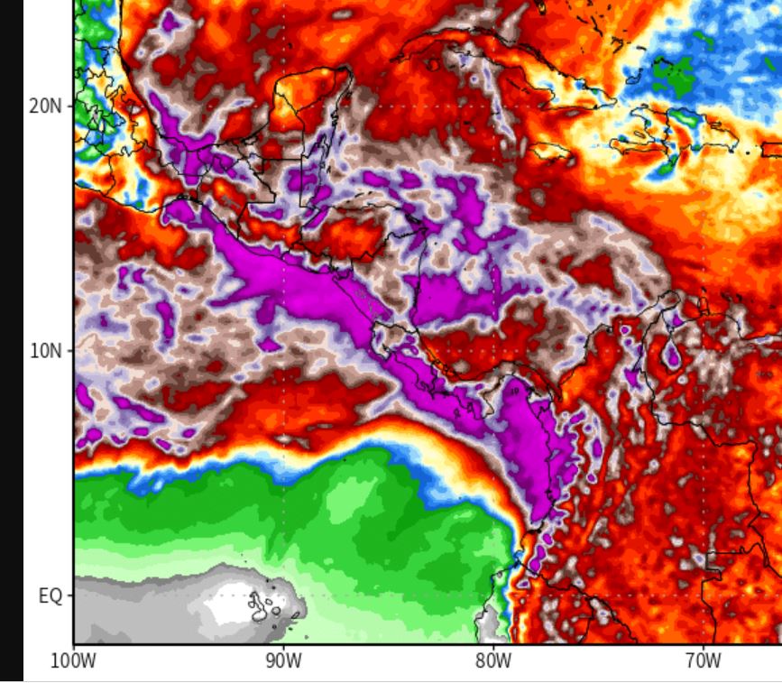
This morning there is a colossal 2.8 million km2 area of intense convection over the Nth South America/Amazon rain forest south of #Invest91L
Here is a view of the dominant convective system in all of this which has formed directly south of #Invest91L - and is shaped like a pine cone.
#HurricaneIAN is finally leaving the United States.
Meanwhile "diturbance" #Invest91L - which may soon become #HurricaneJulia - has taken on the appearance of a comet. 

#Invest91L at sunset 5th October 2022
#ExtremeWeather Update
The NHC has updated its view on #Invest91L and now gives it a 60% chance of Tropical Storm formation in 2 days.
I'm wondering if it may already be a tropical storm as it has grown significantly in size in recent hours.

The NHC has updated its view on #Invest91L and now gives it a 60% chance of Tropical Storm formation in 2 days.
I'm wondering if it may already be a tropical storm as it has grown significantly in size in recent hours.


The official NHC call is now 40% formation chance for #Invest91L in 48 hours 60% in 5 days. But I suspect that's still a significant over-estimation. 


This was early this morning before sunrise - long animation loop.
#ClimateChangeNow #ExtremeWeatherUpdate THREAD
#Invest91L located East of the Seaward Islands has woken up at day break with explosive convection - and is starting to look organised.
This storm is forecast to move towards the Gulf of Mexico.
#Invest91L located East of the Seaward Islands has woken up at day break with explosive convection - and is starting to look organised.
This storm is forecast to move towards the Gulf of Mexico.
In the long range PWAT animation in the quoted thread above you can see one possible outcome, a massive cyclone embedded in a gyre which nearly covers the entire Gulf of Mexico.
But that is still a long way off and can probably be considered a worst case scenario.
But that is still a long way off and can probably be considered a worst case scenario.
#ExtremeWeather Update.
There is a lot going on in the Tropical & North Atlantic over the coming fortnight in this latest GFS run. Including two hurricane's and the continuing impact of the remnants of #HurricaneIAN in NE Nth America.
There is a lot going on in the Tropical & North Atlantic over the coming fortnight in this latest GFS run. Including two hurricane's and the continuing impact of the remnants of #HurricaneIAN in NE Nth America.
Here's the PWAT version. For Texas's sake it would be best if #Invest91L does not become a TS/Hurricane.
But there are a few other features in that forecast which are alarming. In the short term the MLSP shows the remnants of #HurricaneIAN remaining stationary just off the coast of Maryland for the next 48 hours. Which means this storm is not going away for two days.
Latest HWRF model run is predicting hurricane development out of #Invest91L 2nd image shows very closely aligned track forecast data which puts this system on a very similar track into the Carribean to #HurricaneIan 


Overnight Satellite presentation on #Invest91L
Note that there is a second area of interest being monitored by NHC a further East also in Hurricane alley.
In this CMISS diagnostic animation of #Invest91L you can see it has favourable low shear conditions for further development and a fairely clear circulation.
In this CMISS diagnostic animation of #Invest91L you can see it has favourable low shear conditions for further development and a fairely clear circulation.
#HurricaneIan Update.
Additional extraordinary satellite observations.
As Hurricane Ian was making landfall in the Carolinas its atmospheric river exhaust was arriving in the Netherlands & Germany.
Additional extraordinary satellite observations.
As Hurricane Ian was making landfall in the Carolinas its atmospheric river exhaust was arriving in the Netherlands & Germany.
Even the most generous forecasts of the sheer extent of #Hurricane's impacts did not come close. As you can see here in the 12 hours after SC landfall, the Hurricane's remnants brought rain to all of West Virginia and Pennsylvania as well as NYC.
But that was not the end of it, in the evening and overnight yesterday the storm separated from its supporting atmospheric river and continued to revolve over Ohio, NC and Pennsylvania. The center of rotation appears to have been over WV and Eastern NC


