Discover and read the best of Twitter Threads about #INFA
Most recents (19)
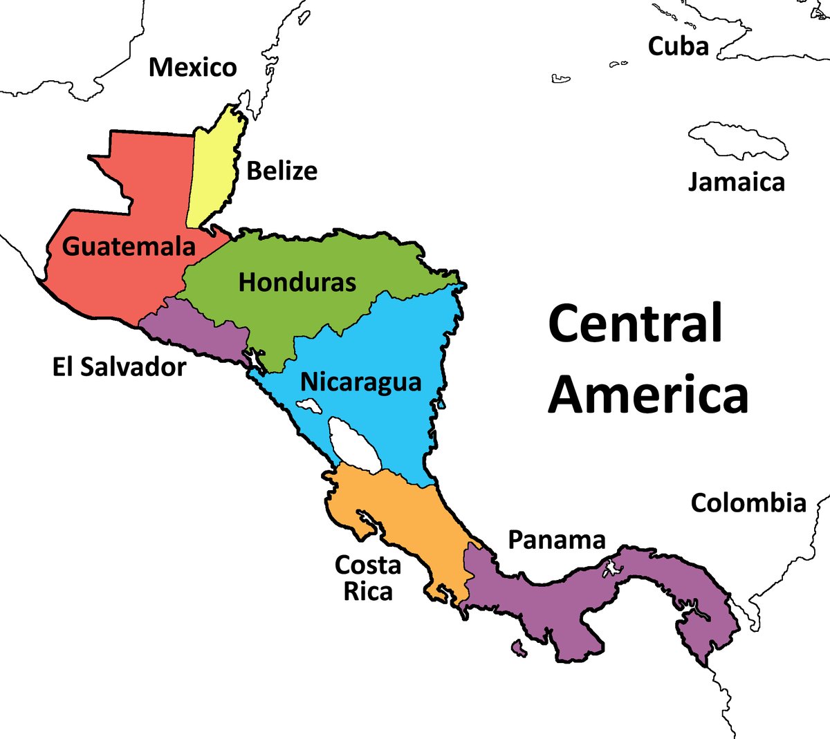
#CentralAmerica #ClimateChangeNOW #ExtremeWeather #HurricaneJulia #IMPACT 16-day assessment THREAD.
It is time to consider what is about to happen in Central America from a #LossAndDamages perspective.
It is time to consider what is about to happen in Central America from a #LossAndDamages perspective.

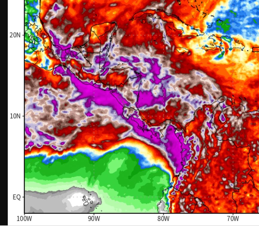
With less than 72 hours till #HurricaneJulia's expected landfall in Nicaragua, #TD13L #PC13L #Invest91L has already wreaked untold havoc in Venezeula, it is now over Colombia. The death toll is rising.
What is ahead is dangerous. #ExtremeWeather impacts for 200 million souls.

What is ahead is dangerous. #ExtremeWeather impacts for 200 million souls.


#HurricaneIAN is very large, very wet and headed inland. The possibility of strengthening once if it finds itself back over open water is non-zero. It is already being fueled by water/convection from the Atlantic side of Florida. 

The eye is 60kms wide at present and it is very slow moving - which is bad news from a landfall winds and flooding perspective. Storm surge impacts and flooding impacts are already extreme.
The capacity of giant storms to maintain strength over land is considerable (#INFA 2021).
The capacity of giant storms to maintain strength over land is considerable (#INFA 2021).

#ClimateChangeNow
Typhoon Muifa lashes eastern China, forcing 1.6 million people from homes sc.mp/o406?utm_sourc… via @scmpnews
Typhoon Muifa lashes eastern China, forcing 1.6 million people from homes sc.mp/o406?utm_sourc… via @scmpnews
@SCMPNews 24 hour satellite loop.
12 hour satellite closer view of Shanghai landfall.
#ClimateChangeNow THREAD
Hurricane #Estelle has spun up & grown into a massive 800k wide storm.
Whilst #Estelle is expected to remain over open water its impact on the Tropical Mega-Atmospheric river mean it's impacts will be felt in East Asia 13k kms away.
Hurricane #Estelle has spun up & grown into a massive 800k wide storm.
Whilst #Estelle is expected to remain over open water its impact on the Tropical Mega-Atmospheric river mean it's impacts will be felt in East Asia 13k kms away.
I discussed this in my thread 13 days ago which takes a deep dive into the relationship between a more extreme tropical rain belt and #extremeweather globally.
#Estelle is stronger than models had expected four days ago ,and is currently forecast to become a major hurricane tomorrow.
Like Hurricane Darby (which remains active) take a fairly straight trajectory keeping it away from coastal North America.

Like Hurricane Darby (which remains active) take a fairly straight trajectory keeping it away from coastal North America.


#ExtremeWeather #Warning #SouthEastAfrica
With formation of Tropical Storm #Emnati overnight and a high confidence forecast for the next five days. We need to also pay attention to potential impacts in Southern Africa, especially in the East.
Latest GFS 10 day rain sim below.
With formation of Tropical Storm #Emnati overnight and a high confidence forecast for the next five days. We need to also pay attention to potential impacts in Southern Africa, especially in the East.
Latest GFS 10 day rain sim below.
While Tropical Storm #Dumako has lost its JTWC designation the threat it poses to Mozambique is not over - we just won't have the same level of data to watch it as it crosses the Mozambique Channel.
The current spaghetti analysis from ECMWF suggests it won't strengthen.
The current spaghetti analysis from ECMWF suggests it won't strengthen.

However in the rainfall forecast we can see that heavy rain is forecast for Southern Mozambique and across the the continent over the next 10 days. This animation is from earlier today before #Dumako was taken off the monitoring list.
Very Intense Cyclone Batsirai #ExtremeWeather Update 4. 3/2/21
#Batsirai has slowed down to a crawl, it has been moving WSW at 5mph (7kmh) for the past 17 hours at least. It is also wobbling and weakening. But the current official forecasts do not reflect this WRT to landfall.

#Batsirai has slowed down to a crawl, it has been moving WSW at 5mph (7kmh) for the past 17 hours at least. It is also wobbling and weakening. But the current official forecasts do not reflect this WRT to landfall.


This is common for an EWRC [Eye Wall Replacement Cycle], after which the storm can be expected to strengthen rapidly. #Batsirai's eye is certainly now very ragged. (images here used to verify speed and heading data). It appears the track is to the north of the current forecast. 


This thread is about Typhoon #INFA, a storm the likes of which the world has never seen before. Enduring, unpredictable, astonishingly wet, massive, slow moving, and never alone.
And 13 days after designation as a storm, #INFA is far from finished in its journey of destruction


And 13 days after designation as a storm, #INFA is far from finished in its journey of destruction


My coverage of #INFA began on 14th July after it had formed into a visible and formidable storm, albeit not yet a Typhoon. But by then weather models already showed it was a significant threat.
Not simply as a storm but as a broader weather pattern.
Not simply as a storm but as a broader weather pattern.
The area in which the storm was expected to form showed up in the models earlier. Here we see it on the 10th of July in the GFS MLSP forecast. But it was probably there even earlier.
A global weather surveillance thread.
We begin in the West Pacific where Typhoon #INFA is now over China bringing rain to 100s of millions.
We begin in the West Pacific where Typhoon #INFA is now over China bringing rain to 100s of millions.
Here's a closeup of #INFA over the past 12 hours rain bands have now reached the already flooded Henan province.
Some early coverage of the impact here: nypost.com/2021/07/26/chi…
Including more harrowing video of flooding.
Including more harrowing video of flooding.
This week's rainfall forecasts for the #HornOfAfrica, #NorthAfrica and the #Middle East follow.
Image: Typhoon INFA over China showing the lights of Tokyo where the world is gathered to celebrate youth & excellence and the unity of the nations of the world at the Olympics.
Image: Typhoon INFA over China showing the lights of Tokyo where the world is gathered to celebrate youth & excellence and the unity of the nations of the world at the Olympics.
At the moment & Impact of Typhoon "Fireworks"at Shanghai Pudong Airport and Hongqiao Airport, all passenger inbound and outbound flights were cancelled. In peak conditions, the two airports have more than 2,000 inbound and outbound flights per day.
#China
#China
This animation shows 24 hours in the life of three storms in the West Pacific. The remnants of former Typhoon #Cempaka bottom left, Typhoon #INFA in the middle and TS #Nepartak far right which is headed to Japan.
Shangai is already receiving rain from In-fa, 650kms away.
Shangai is already receiving rain from In-fa, 650kms away.
A truly extraordinary storm. Maybe illustrative of what tropical storms of the future may look like.
#INFA developed slowly, moves slowly and is not particularly strong, but he/she is orchestrating rain catastrophes from 100s of KMs away in Shangai the Phillipines and Japan.
#INFA developed slowly, moves slowly and is not particularly strong, but he/she is orchestrating rain catastrophes from 100s of KMs away in Shangai the Phillipines and Japan.

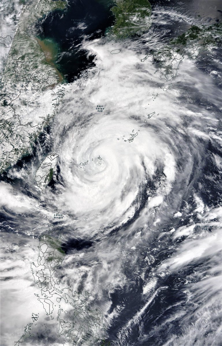
A big high resolution photo of INFA from this morning from @NASA WorldView. This is a truly huge storm. 
A brief pictorial thread of parts of the northern hemisphere where extreme or unusual weather phenomena are underway.
Starting with #eastasia #infa & #3rdStorm which seems to have initiated formation. This is the storm which will crash #Olympics2021, shortly after the opening.
Starting with #eastasia #infa & #3rdStorm which seems to have initiated formation. This is the storm which will crash #Olympics2021, shortly after the opening.
The 1st animation is 120 hours. This version goes for 11 days longer. As on #infa’s path beyond 120 hours, what happens beyond July 26th is pretty uncertain. #infa is also continuously not behaving as expected, totes normal for a heat engine of this magnitude.
Heading west a few thousand miles the lingering impact of the #ArabianMomsoonBurst is set to continue for some time bringing thunderstorms to the Arabian peninsula on a daily basis. See @Arab_Storms for video reports.
#INFA and a widening gyre.
July 22nd #Japan #Olympics2021 weather update, rain, wind, rain and more rain. This is not looking at all ok.
TL/DR: the model forecasts for East Asia have changed. And gotten significantly worse.
July 22nd #Japan #Olympics2021 weather update, rain, wind, rain and more rain. This is not looking at all ok.
TL/DR: the model forecasts for East Asia have changed. And gotten significantly worse.
Here's a high resolution satellite image of Typhoon #INFA which is continuing to defy all predictions.
But the potential impacts of this storm both for those in its path and for the wider region are getting steadily worse.
But the potential impacts of this storm both for those in its path and for the wider region are getting steadily worse.

Yesterday's thread can be found here >>
TL/DR the only hope at this point is that the models can't compute this right, and what they say will happen doesn't.
It's now time for prayer, and for Japan to prepare for widespread catastrophic rainfall.
TL/DR the only hope at this point is that the models can't compute this right, and what they say will happen doesn't.
It's now time for prayer, and for Japan to prepare for widespread catastrophic rainfall.
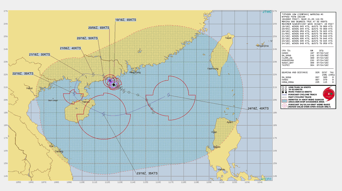
ECMWF ensembles showing the Fujiwhara effect between Typhoon #Cempaka 🌼 and Typhoon #Infa 🎆 as the two storms were forecasted to move around each other 🌀 

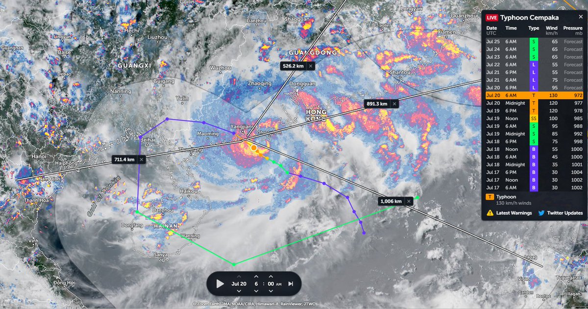
Typhoon #Cempaka rapidly intensifying while drifting slowly offshore of Guangdong Province, China (#Cempaka name meaning: a type of tree with fragrant flowers 🌼 name origin: Malaysia)
Today's #FabianPH #INFA, #Olympics, #Olympics2021 disruption update thread.
See yesterday's thread below.
TL/DR: There is a significant typhoon/extreme rainfall threat to Japan in the opening days of the Olympics.
See yesterday's thread below.
TL/DR: There is a significant typhoon/extreme rainfall threat to Japan in the opening days of the Olympics.
Here's a view of the two storms, #FabianPH / #INFA whose interaction is forecast to produce a 3rd storm in 4 days time which was forecast yesterday to arrive in Tokyo two days after the Olympics opening.
#Olympics, #Olympics2021
#Olympics, #Olympics2021
In the latest GFS 1hourly simulation model the solution remains the same as of today. A large typhoon like low (in terms of water content) will make landfall in Japan and stay over the country for some time bringing torrential rains during #Olympics2021
#Fabian #FabianPH #INFA
#Fabian #FabianPH #INFA
This attached thread from this morn looks at Typhoon #INFA ("In-fa" TS09W) which is poised to be extraordinarily disruptive to the 2021 Olympics in Japan.
It has since come clearer what we can expect from a dangerous and unusual weather system developing over the West Pacific.
It has since come clearer what we can expect from a dangerous and unusual weather system developing over the West Pacific.

This is the story of three storms rather than one, but IN-FA will play the starring role.
1. TD10W currently menacing Hong Kong
2. "IN-FA" which is technically still TS09W (fmrl. #invest98w)
& a 3rd storm which models forecast TD10W & IN-FA will bring about in 5 days time.
1. TD10W currently menacing Hong Kong
2. "IN-FA" which is technically still TS09W (fmrl. #invest98w)
& a 3rd storm which models forecast TD10W & IN-FA will bring about in 5 days time.

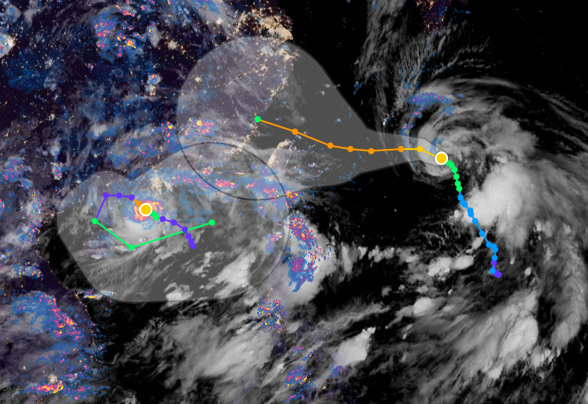
Here's the latest satellite imagery of TD10W (left) and #INFA (right) 


