Discover and read the best of Twitter Threads about #Batsirai
Most recents (20)
At an event held for “Global Early Warning System” efforts for extreme weather (droughts/cyclones) the night before last I had the great pleasure of meeting a delegation from Madagascar which experienced a series of 6 landfalling cyclones, several very damaging in 2021. #cop27 


One of the worst was Cyclone #Batsirai seen in the quoted thread below.
One of the apparent trends for cyclones over the past few years has been to see patterns of storms following similar routes. Providing successive shocks to vulnerable communities like Madagascar.
One of the apparent trends for cyclones over the past few years has been to see patterns of storms following similar routes. Providing successive shocks to vulnerable communities like Madagascar.
#ExtremeWeather #Emnati #TCEmnati Update:
Recent @NOAA GFS simulation model runs for #Emnati are continuing to show the storm turning towards the south as it is north of Reunion island which would mitigate the worst threats to #Madagscar.
Impact comment from RMSC/@MeteoFrance

Recent @NOAA GFS simulation model runs for #Emnati are continuing to show the storm turning towards the south as it is north of Reunion island which would mitigate the worst threats to #Madagscar.
Impact comment from RMSC/@MeteoFrance

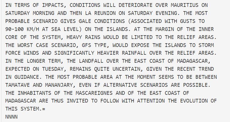
The model guidance though is unclear (image below shows latest @ECMWF model landfall solution). The numerical model guidance is discussed from the same @MeteoFrance advisory issued at midnight.
The official track still shows catastrophic landfall in #Batsirai affected areas.


The official track still shows catastrophic landfall in #Batsirai affected areas.


@ECMWF @meteofrance Spaghetti ensemble runs below for GEFS (L) and EPS (R) (right).] These show the current trajectory disagreement clearly.
[HT to @WXNB_ : ]
As he says an improved impact outcome for Madagascar will likely mean a worse result for La Reunion.

[HT to @WXNB_ : ]
As he says an improved impact outcome for Madagascar will likely mean a worse result for La Reunion.


#ExtremeWeather #Warning #SouthEastAfrica
With formation of Tropical Storm #Emnati overnight and a high confidence forecast for the next five days. We need to also pay attention to potential impacts in Southern Africa, especially in the East.
Latest GFS 10 day rain sim below.
With formation of Tropical Storm #Emnati overnight and a high confidence forecast for the next five days. We need to also pay attention to potential impacts in Southern Africa, especially in the East.
Latest GFS 10 day rain sim below.
While Tropical Storm #Dumako has lost its JTWC designation the threat it poses to Mozambique is not over - we just won't have the same level of data to watch it as it crosses the Mozambique Channel.
The current spaghetti analysis from ECMWF suggests it won't strengthen.
The current spaghetti analysis from ECMWF suggests it won't strengthen.

However in the rainfall forecast we can see that heavy rain is forecast for Southern Mozambique and across the the continent over the next 10 days. This animation is from earlier today before #Dumako was taken off the monitoring list.
#ExtremeWeather TS #Emnati Update:
After a night of explosive convection and organisation What was #96s #Invest96s or #TD5 is now #TSEmnati - and forecast to become - like #Batsirai an Intense Tropical Cyclone on Sunday packing Cat3 Hurricane intensity winds of 185kmh.
After a night of explosive convection and organisation What was #96s #Invest96s or #TD5 is now #TSEmnati - and forecast to become - like #Batsirai an Intense Tropical Cyclone on Sunday packing Cat3 Hurricane intensity winds of 185kmh.
And the good news is that JTWC - [metoc.navy.mil/jtwc/jtwc.html… website seems to be back online. They were missed. Here is the latest official track forecast issued by JTWC Pearl Harbour this morning at 3:00Z (UTC). This storm can now be considered to be a major threat to Madagascar. 

The forecast track is almost identical to that of #Batsirai, which has left over 120 Malagasy dead, destroyed and damaged 10s of thousands of homes and buildings. Flooded areas have not even drained yet.
#ExtremeWeather Update Thread: Madagascar #Invest96S
The JTWC is now saying there is a "High" probability of #Invest96S will become a TC within the next 24 hours.
The JTWC @USNavy @USNRL website [Here: metoc.navy.mil/jtwc/jtwc.html] remains inaccessible.
The JTWC is now saying there is a "High" probability of #Invest96S will become a TC within the next 24 hours.
The JTWC @USNavy @USNRL website [Here: metoc.navy.mil/jtwc/jtwc.html] remains inaccessible.

@USNavy @USNRL While we do not have a JTWC track forecast yet, we do have a new forecast. the relevant part for #96s is in the 2nd image here and contains reasoning as to why:
"THE POTENTIAL FOR THE DEVELOPMENT OF A SIGNIFICANT TROPICAL CYCLONE WITHIN THE NEXT 24 HOURS IS UPGRADED TO HIGH."


"THE POTENTIAL FOR THE DEVELOPMENT OF A SIGNIFICANT TROPICAL CYCLONE WITHIN THE NEXT 24 HOURS IS UPGRADED TO HIGH."


Here's a current 24h animation of the storm, at the end you see the center of circulation is fully exposed. The storm is moving fairly fast and is being blown westwards by winds which are creating a lot of shear - which prevents development.
This #ExtremeWeather thread on #Invest96s in the Indian Ocean is a weird one.
It began with apparent cancellation of the designation of two colliding tropical disturbances by the #JTWC (Joint Typhoon Warning Center) last night, followed by its re-designation this afternoon.
It began with apparent cancellation of the designation of two colliding tropical disturbances by the #JTWC (Joint Typhoon Warning Center) last night, followed by its re-designation this afternoon.
The re-designation wasn't by JTWC - which is having website outage issues - but rather by the RSMC, the local meteorological authorities in the Reunion & @meteofrance
"***************CORRECTIVE**************
RSMC / TROPICAL CYCLONE CENTER / LA REUNION"
"***************CORRECTIVE**************
RSMC / TROPICAL CYCLONE CENTER / LA REUNION"
If #Invest96s becomes a cyclone and intensifies, models indicate it will become the fourth cyclone to strike Madagascar in two months - possibly as the 2nd major cyclone.
It would follow #StormAna #Batsirai & #Dumako which made landfall in the north of Madagascar today.
It would follow #StormAna #Batsirai & #Dumako which made landfall in the north of Madagascar today.
#ExtremeWeather Update:
The JTWC @USNavy run portal for Global surveillance/tracking of dangerous cyclones - seems to be out of action, inaccessible via the web, again.
Just as a third tropical storm is making landfall on Madagascar in the space of a month. @USNRL @WMO
The JTWC @USNavy run portal for Global surveillance/tracking of dangerous cyclones - seems to be out of action, inaccessible via the web, again.
Just as a third tropical storm is making landfall on Madagascar in the space of a month. @USNRL @WMO
The Joint Typhoon Warning Center website is here >> metoc.navy.mil/jtwc/jtwc.html
It has been unreliable for several months normally it looks like the 2nd image here below (image src: cyclocane.com - which aggregates cylone/storm data)

It has been unreliable for several months normally it looks like the 2nd image here below (image src: cyclocane.com - which aggregates cylone/storm data)


Tropical Depression 96S (see previous tweet) is the storm that is currently forecast by most models to develop into a dangerous cyclone threatening Madagascar and possibly SE Africa.
The storm was removed from the watch list yesterday morning - then reinstated this afternoon.
The storm was removed from the watch list yesterday morning - then reinstated this afternoon.
Madagascar #ExtremeWeather Thread:
Yet another Indian Ocean Tropical Storm, #Dumako is forecast to make landfall in Madagascar in the next 24 hours.
And at around the same time models suggest a more dangerous Tropical Cyclone may form following closely behind.
Yet another Indian Ocean Tropical Storm, #Dumako is forecast to make landfall in Madagascar in the next 24 hours.
And at around the same time models suggest a more dangerous Tropical Cyclone may form following closely behind.
#Dumako is a relatively minor storm and is forecast to weaken on its approach but as you can see here, simulations are pointing to a more dangerous storm following closely in Dumako's wake.
The new cyclone is modelled to form as #Invest93s & #Invest96s merge.
The new cyclone is modelled to form as #Invest93s & #Invest96s merge.
At this stage this formation event is just a possibility, but if it does take place landfall will follow fairly quickly afterwards, and at the moment its track over Madagascar looks very similar to that of #Batsirai which killed over 100 people and destroyed around 100,000 homes.
#ExtremeWeather Update 7: Madagascar
Whilst #CycloneBatsirai has now passed, Madagascar is not yet out of danger as the South Indian Ocean Cyclone Season remains very active.
Thread...
Whilst #CycloneBatsirai has now passed, Madagascar is not yet out of danger as the South Indian Ocean Cyclone Season remains very active.
Thread...
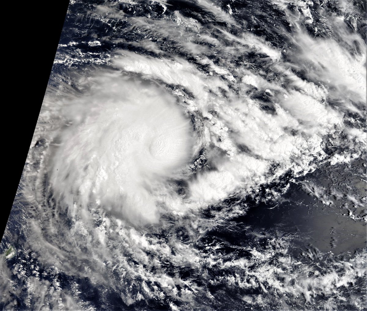
Here is a satellite image of #Batsirai as it leaves Madagascar heading due south.
This morning a media briefing from @UNICEF @UNGeneva addressed humanitarian crises in East Africa, many of which are climate related. And included a briefing on Madagascar and its recent storms. media.un.org/en/asset/k1b/k… 

[A LA UNE A 20H]
Le président français Emmanuel #Macron a dit qu'il espérait amorcer une "désescalade" dans la crise russo-occidentale autour de l'Ukraine, au début de sa rencontre au Kremlin avec son homologue russe Vladimir #Poutine #AFP 1/5
Le président français Emmanuel #Macron a dit qu'il espérait amorcer une "désescalade" dans la crise russo-occidentale autour de l'Ukraine, au début de sa rencontre au Kremlin avec son homologue russe Vladimir #Poutine #AFP 1/5

[A LA UNE A 20H]
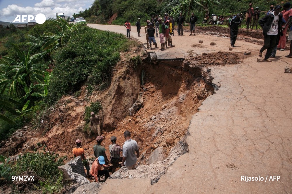
Le cyclone #Batsirai a quitté Madagascar en épargnant les principales villes mais laisse des dizaines de milliers de sinistrés, 21 morts et le "grenier à riz" du centre du pays ravagé, faisant craindre une aggravation de la crise humanitaire #AFP 2/5
Le cyclone #Batsirai a quitté Madagascar en épargnant les principales villes mais laisse des dizaines de milliers de sinistrés, 21 morts et le "grenier à riz" du centre du pays ravagé, faisant craindre une aggravation de la crise humanitaire #AFP 2/5
[A LA UNE A 20H]
Le chef de la diplomatie ukrainienne a accusé la Russie de chercher à "creuser un fossé" entre Kiev et ses alliés occidentaux, en recevant son homologue allemande Annalena Baerbock pour une visite de soutien dans la crise avec Moscou #AFP 3/5
Le chef de la diplomatie ukrainienne a accusé la Russie de chercher à "creuser un fossé" entre Kiev et ses alliés occidentaux, en recevant son homologue allemande Annalena Baerbock pour une visite de soutien dans la crise avec Moscou #AFP 3/5

Latest JTWC forecast for #Batsirai shows it deviating from its predicted path. "THE LLCC MOVED OFFSHORE AROUND 061600Z, THEN TRACK NEARLY DUE WEST OR A BIT NORTH OF DUE WEST, BUT BASED ON THE MICROWAVE IMAGERY, APPEARS TO HAVE BECOME QUASI-STATIONARY NEAR THE INITIAL POSITION." 

Full reasoning from JTWC here >> metoc.navy.mil/jtwc/products/…
#Batsirai has stalled & is expected to follow its existing track forecast. In the short term (36 hrs) it may intensify. The latest model guidance (GEFS plot below) does not take into account the change in behaviour


#Batsirai has stalled & is expected to follow its existing track forecast. In the short term (36 hrs) it may intensify. The latest model guidance (GEFS plot below) does not take into account the change in behaviour

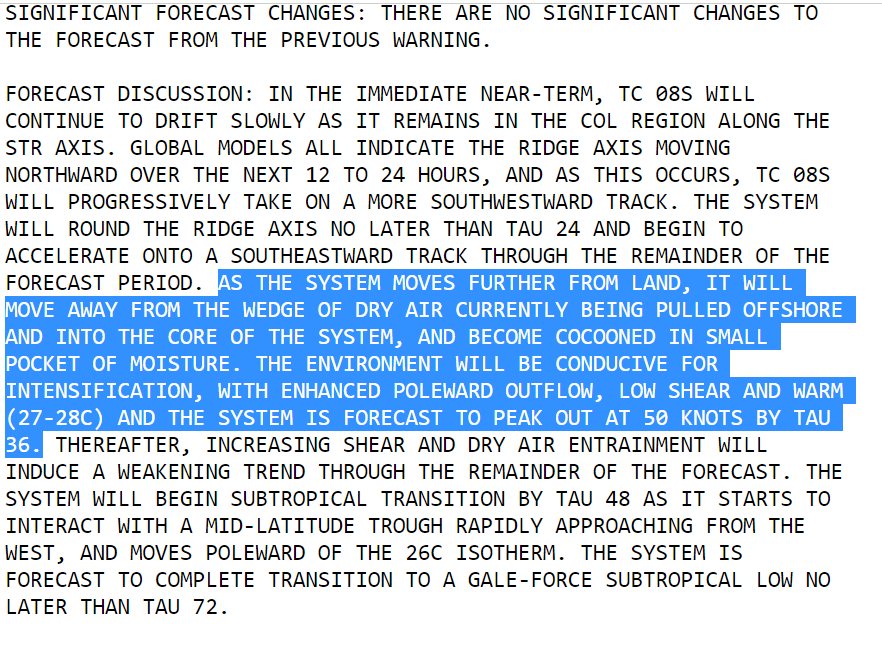

The track forecast has now been updated and #Batsirai appears now to be in the process of making the sharp turn to the south in the latest JTWC update.
Destroyed by storm surge and hurricane force winds. Pictures from the epicenter of Cyclone #Batsirai’s landfall
Another video tweet.
Horrific looking flooding pictures, likely from an area near the Capital where the heaviest rain fell. #CycloneBatsirai
#Batsirai #ExtremeWeather Update Thread 6:
The center of Intense Cyclone Batsirai has nearly completed its crossing of Madagascar but the storm/wind field continues to impact the southern half of the island.
The center of Intense Cyclone Batsirai has nearly completed its crossing of Madagascar but the storm/wind field continues to impact the southern half of the island.
The most intense rainfall was concentrated near the Capital City Antisirabe, the 4th largest city moving slowly. Extreme flooding in this area appears likely. And there were two additional extreme rainfall events in the North and the West of the island, fueled by the storm.
We see in this image that the eye of the storm (with its most damaging winds) remained intact for several hours after landfall finally losing its structure in the early hours Sunday Morning.
The lightning display as seen in satellite imagery during this period is extraordinary.
The lightning display as seen in satellite imagery during this period is extraordinary.
#Batsirai #ExtremeWeather Update Thread:
Cyclone Batsirai is weakening and accelerating on its final approach to Madagascar's East Coast. But while lower winds will be helpful - it's primary impact - widespread very heavy rain - is likely to be extreme.
Cyclone Batsirai is weakening and accelerating on its final approach to Madagascar's East Coast. But while lower winds will be helpful - it's primary impact - widespread very heavy rain - is likely to be extreme.
Cyclone #Batsirai was expected to reach eastern Madagascar on Saturday, posing a "very serious threat" to millions with powerful winds and torrential rains set to batter the large Indian Ocean island u.afp.com/wYwR #CycloneBatsirai 
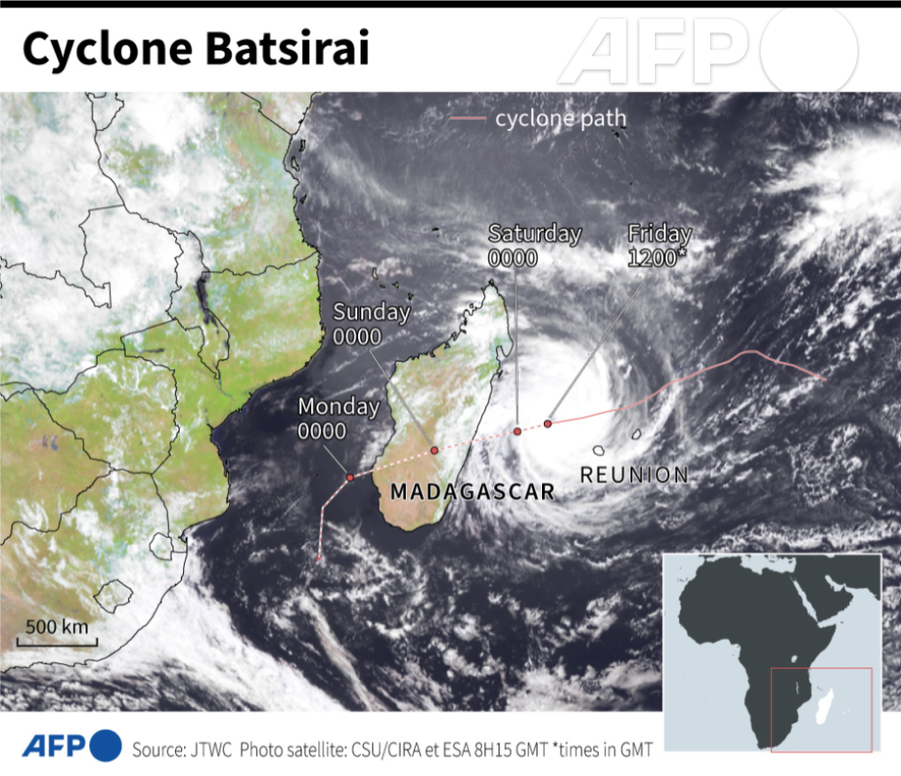
VIDEO: 🇷🇪🇲🇺 A Mauritian oil tanker has run aground on the south coast of #ReunionIsland during heavy weather caused by the passage of #CycloneBatsirai. The 11 sailors on the Tresta Star, which was sailing empty of cargo, were rescued
#UPDATE As #CycloneBatsirai neared eastern #Madagascar on Saturday people sought shelter in more secure concrete buildings while others reinforced their roofs with sandbags. The Meteo-France weather service has warned of winds of up to 260 kph (162mph) u.afp.com/wYwR 

#Batsirai #ExtremeWeather Update Thread.
As a poster child for the impact of climate change on developing nations this cyclone, is a truly terrifying phenomena. In the next 24 hours it will make landfall at most likely Cat 4 or Cat 5 Hurricane Strength.
As a poster child for the impact of climate change on developing nations this cyclone, is a truly terrifying phenomena. In the next 24 hours it will make landfall at most likely Cat 4 or Cat 5 Hurricane Strength.
The animation above is live and covers the last three hours. This animation shows the last 24 hours.
Madagascar is an impoverished nation of nearly 30 million people the majority of whom live in the path of this Cyclone's wind and forecast extreme rain.
Madagascar is an impoverished nation of nearly 30 million people the majority of whom live in the path of this Cyclone's wind and forecast extreme rain.
Whilst at Cat 4 strength a day ago what was already Intense Cyclone #Batsirai underwent a eyewall replacement and slowed down, it is now accelerating and strengthening. 

Very Intense Cyclone Batsirai #ExtremeWeather Update 4. 3/2/21
#Batsirai has slowed down to a crawl, it has been moving WSW at 5mph (7kmh) for the past 17 hours at least. It is also wobbling and weakening. But the current official forecasts do not reflect this WRT to landfall.

#Batsirai has slowed down to a crawl, it has been moving WSW at 5mph (7kmh) for the past 17 hours at least. It is also wobbling and weakening. But the current official forecasts do not reflect this WRT to landfall.


This is common for an EWRC [Eye Wall Replacement Cycle], after which the storm can be expected to strengthen rapidly. #Batsirai's eye is certainly now very ragged. (images here used to verify speed and heading data). It appears the track is to the north of the current forecast. 


Update Thread:
#ExtremeWeather #Madagascar #Batsirai #CycloneBatsirai
Intense Cyclone Batsirai has strengthened rapidly and grown significantly larger. It has now passed Mauritius and its outer bands are now over Reunion.
#ExtremeWeather #Madagascar #Batsirai #CycloneBatsirai
Intense Cyclone Batsirai has strengthened rapidly and grown significantly larger. It has now passed Mauritius and its outer bands are now over Reunion.
Madagascar is 1000kms long top to bottom and #BatsiraiCyclone's outer bands are roughly the same size. With sustained winds of over 113 knots the storm is now the equivalent of a Category 4 Major Hurricane. 

#ExtremeWeather Update Thread:
"Intense Cyclone" #Batsirai is stronger than expected, forecast to strengthen, with a path slightly to the north of previously. It is now expected to land at Cat 3-4 Hurricane intensity - near the centers of population on the island of Madagascar.
"Intense Cyclone" #Batsirai is stronger than expected, forecast to strengthen, with a path slightly to the north of previously. It is now expected to land at Cat 3-4 Hurricane intensity - near the centers of population on the island of Madagascar.
The storm is experiencing a lot of shear, and yet remaining remarkably intact. You can see the ragged eye here north and west of the forecast path with a large wobble.
The access issues I had been experiencing with the #JTWC appear to be fixed. And here is their latest forecast and discussion & reasoning. metoc.navy.mil/jtwc/jtwc.html 


#ExtremeWeather Alert Thread
Cyclone Batsirai is heading towards Madagascar, hot on the heels of Storm Ana which has brought fatal flooding and massive damage to both Madagascar and SE Africa, Mozambique - Malawi & Zimbabwe.
6 hour animation of the storm this morning.
Cyclone Batsirai is heading towards Madagascar, hot on the heels of Storm Ana which has brought fatal flooding and massive damage to both Madagascar and SE Africa, Mozambique - Malawi & Zimbabwe.
6 hour animation of the storm this morning.
Cyclone #Batsirai is a much more intense storm than Storm Ana, and at present nearly all simulation runs from both the European and US models show a landfall on the East Coast of Madagascar in 4-5 days. 




The @USNavy's #JTWC website (metoc.navy.mil/jtwc/jtwc.html) is currently inaccessible from what I can see (possibly due to certificate errors) but this graphic from France Meteo appears to be the current official forecast for #Batsirai. 


