Discover and read the best of Twitter Threads about #ORwx
Most recents (17)
ICE STORM ARRIVES LATE THURS: Getting a lot of questions about the pending ice storm for n.w. Oregon & s.w. Washington. This thread should answer some q’s, including:
1) When will it turn icy?
2) How much ice will accumulate?
3) Roughly when will it thaw out?
#PDX #ORwx #WAwx
1) When will it turn icy?
2) How much ice will accumulate?
3) Roughly when will it thaw out?
#PDX #ORwx #WAwx
Between this afternoon & eve, modified arctic air will surge through the Gorge & spread across the Portland metro area. Temps will drop into the 20s & teens / wind chills in the single digits & maybe below zero. Cold air spreads across western valleys & coastline tonight.
Ice will begin to accumulate late Thurs. By Friday A.M., most surfaces will be glazed over. Populated areas up & down I-5 corridor could pick up ~ 1/10-1/4” of ice. Lots of power outages expected. Pockets of Coast Range, metro area, Cascades & Gorge could see 1/4-1/2”+ of ice.
ICE STORM A FEW DAYS AWAY: The coldest air of the season will spread west of the Cascades between late Wednesday & early Thurs. Many cities in our western valleys will be locked in by freezing air through at least Fri. Temps will gradually warm up this weekend. #PDX #ORwx #WAwx
Initially, cold air will spread all the way down the Willamette Valley & out along the northern Oregon & southern Washington Coast. Eventually, a warmer weather system will erode the cold air away, first along coast, then southern valley, & last in metro area. #PDX #ORwx #WAwx
Precipitation will begin to spread inland Thurs. afternoon, w/ steadier precip. Thursday night. Anything that falls in Coast Range, interior valleys and points to the east will either be snow, a wintry mix or freezing rain. Roads will turn nasty overnight Thurs eve/night.
The Portland/Vancouver metro area is ~ 3 days out from COLD air arriving, and about 4-5 days out from snow transitioning to freezing rain. Ice storm possible Friday. Will know more by Tue/Wed regarding how much snow/ice is coming and who could get hit hardest. #PDX #ORwx #WAwx 

Let’s go over what we know: arctic air will pour across the interior Northwest Wednesday, and will spread west of the Cascades Wednesday night / Thursday A.M.
It won’t be quite as cold west of Cascades as it will be to the east, but still.. prepare for widespread teens & low 20s w/ lower wind chills. Most of Wed/Thurs. will be dry. Warmer moist air will overrun cold air starting Thursday night - Friday A.M. = turning messy in lowlands.
Happy Sunday, all! Wanted to give everyone as much of a heads up as possible about this week, since many will be traveling in the days leading up to Christmas. Some kind of snow/ice event is possible in the Portland metro area, Gorge & Cascade Foothills Thur-Sat. #PDX #ORwx #WAwx 

WEDNESDAY: Starting in afternoon / evening, a cold east wind will be cranking thru the Gorge and across the Portland / Vancouver metro area. This modified arctic air will prime the region with sub-freezing air, setting the stage for a winter weather event Thursday/Friday. #PDX 

THURSDAY: By Thursday morning, our temperatures will be well below freezing, somewhere between the mid teens and low 20s. Due to the strong east wind, temperatures will likely stay below freezing all day long. Colder in Gorge. Precip. will arrive from the west Thursday P.M.
Incessant heavy rain will pile into the Pacific Northwest, USA 🇺🇸 & British Columbia, Canada 🇨🇦 in the next 72 hours due to a significant atmospheric river event.
Flooding & landslides are highly likely. The atmospheric warmth & moisture can be traced all the way to the tropics.
Flooding & landslides are highly likely. The atmospheric warmth & moisture can be traced all the way to the tropics.
A strong meander in the jet stream allows Alaska to cool under Arctic air but also helps lift Tropical warmth & moisture into British Columbia & the Pacific Northwest.
Notice how the atmospheric moisture aligns and focuses on the same area. This is like nature's firehose. Extreme rain and locally very high freezing levels expected. Meteorologists call this an atmospheric river.
Some refer to this atmospheric river as 'the Pineapple Express'.
Some refer to this atmospheric river as 'the Pineapple Express'.
While we're having fun being exasperated by the heat. We want to put it into context. The Rogue Valley is forecast to see max Temps at or above 100 degrees for 9 days in a row (starting yesterday). There have been only 3 times in our history (since 1911) where this has happened.
Two of the streaks reached 10 days (August 1967 and July 1962). The 3rd reached 9 days (August 1990). The other important part of this, is that our overnight low temperatures will only reach into the mid to upper 60s to 70s. This does not give people a chance to recover at night.
Please check in on your neighbors and friends throughout this heat wave. If you know someone who has a broken A/C (or no A/C), invite them over for a cold beverage (be safe with COVID, please). If you're working outside, take frequent breaks in A/C.
Fire weather update: relatively mild (near avg) temps will continue for a few more days across California. Calmer winds will result in poor air quality, as visible this AM. A weak cold front with a few light North Coast showers possible mid-week. But then... #CAwx #CAfire (1/n) 

Escalation of devastating #wildfires, smoke & surface #airpollution across entire western US with very high levels of surface PM2.5 for the coming days. @CopernicusECMWF Atmosphere Monitoring Service @ECMWF forecast initialized 9 Sept at 00 UTC visualized by @windyforecast
Link to forecast ➡️ windy.com/-PM2-5-pm2p5?c… #CAwx #CaliforniaFires #ORwx #OregonFires #WAwx #WashingtonFires #COwx #ColoradoFires #UTwx #UtahFires
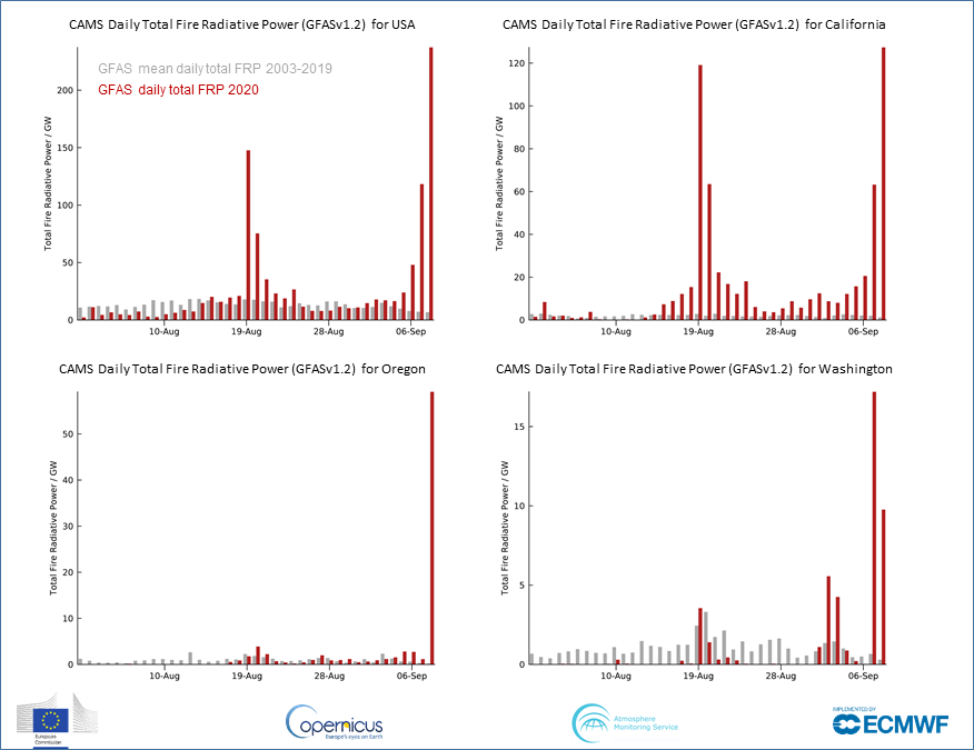
1 Aug - 8 Sept 2020 daily total #wildfire radiative power (cf 2003-2019 mean) for US, #CaliforniaFires, #OregonFires & #WashingtonFires from #CopernicusAtmosphere Monitoring Service GFAS data confluence.ecmwf.int/display/CKB/CA… based on NASA MODIS 🛰️ active fire observations #wildfireseason 
You could write an entire meteorology textbook just based on the phenomena visible from this afternoon's wild satellite imagery looking down at the American West. (Thread) #CAwx #WAwx #ORwx #COwx #UTwx #MTwx #IDwx
Most prominent is incredibly strong early-season cold front plunging southward from Canada and currently stretching along a roughly east-west axis from Eastern Washington to North Dakota. Clouds are rapidly developing behind the front as cold air replaces a very hot airmass.
Next, there are numerous large wildfire smoke plumes visible in nearly every state not covered by clouds--including Washington, Oregon, California, Utah, Idaho, and Colorado. The total smoke volume is massive, and extends across most of the continental U.S.
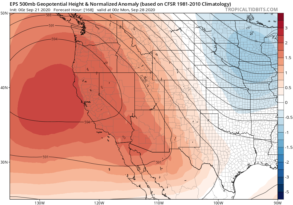
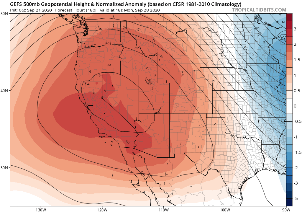
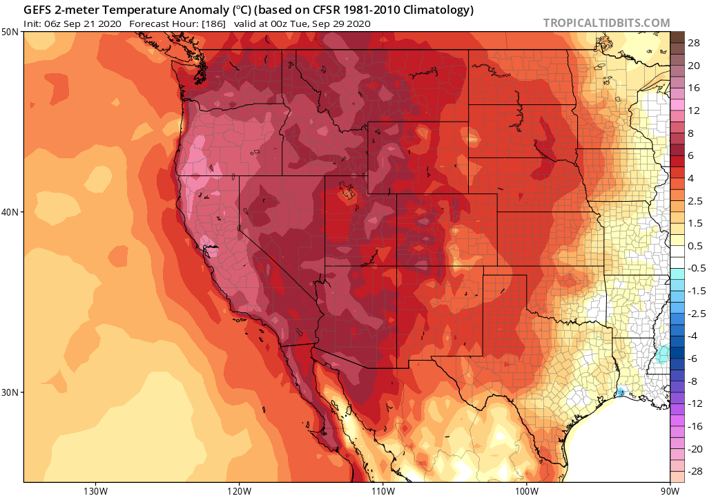
Extremely dry and easterly windy conditions will develop over the Cascades later today followed by a moderate event in the N Sierra Foothills, Sac Valley and N Bay Area, then a Santa Ana. Quick roundup of what NWS offices are saying about this event: 1/n
#cawx #orwx #firewx


#cawx #orwx #firewx
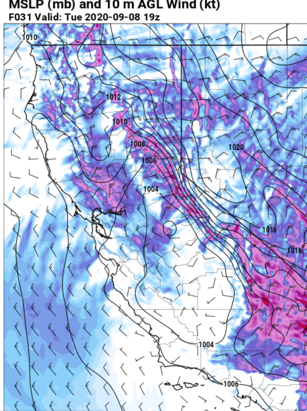
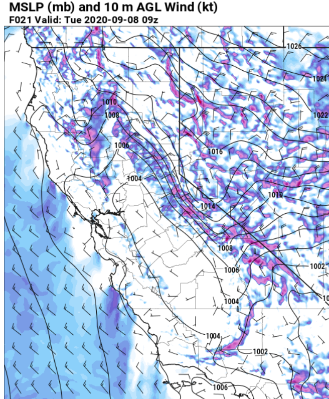
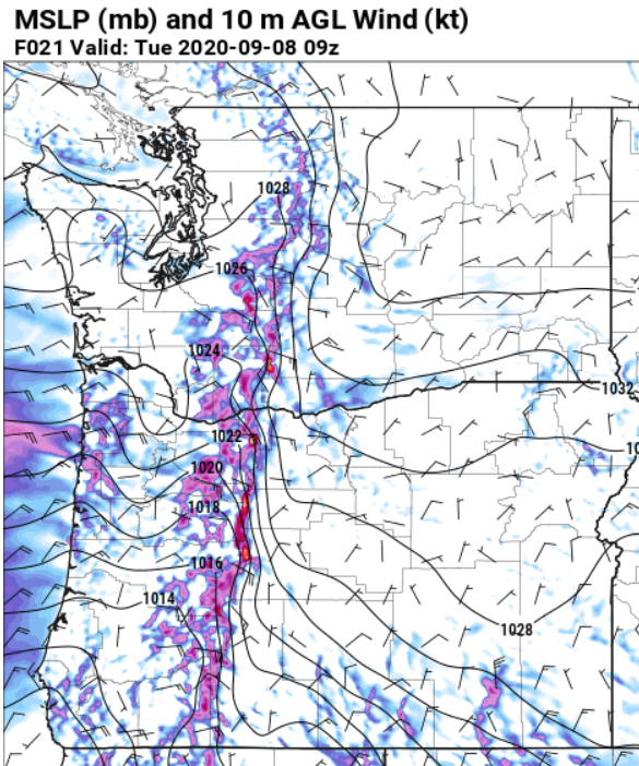
NWS Portland:
“All the ingredients are coming together as expected for a potent and likely historic September East Wind event
... that only occurs a couple times a century in September. Extreme fire danger and locally damaging winds are likely. 2/n
“All the ingredients are coming together as expected for a potent and likely historic September East Wind event
... that only occurs a couple times a century in September. Extreme fire danger and locally damaging winds are likely. 2/n
NWS Portland cont:
"The strongest east winds still appear to focus through the gap in the high Cascades between Mt Adams and Mt Hood … western portions of the Columbia Gorge, Portland/Vancouver metro area, north Oregon Coast and Coast Range” The Coast Range too!. 3/n
"The strongest east winds still appear to focus through the gap in the high Cascades between Mt Adams and Mt Hood … western portions of the Columbia Gorge, Portland/Vancouver metro area, north Oregon Coast and Coast Range” The Coast Range too!. 3/n
🌩️ Yesterday’s lightning event resulted in approximately 140 lightning strikes across Lake and Klamath counties. Of those strikes, 12 fires were reported with the largest being ten and a half acres. #FireYear2020 
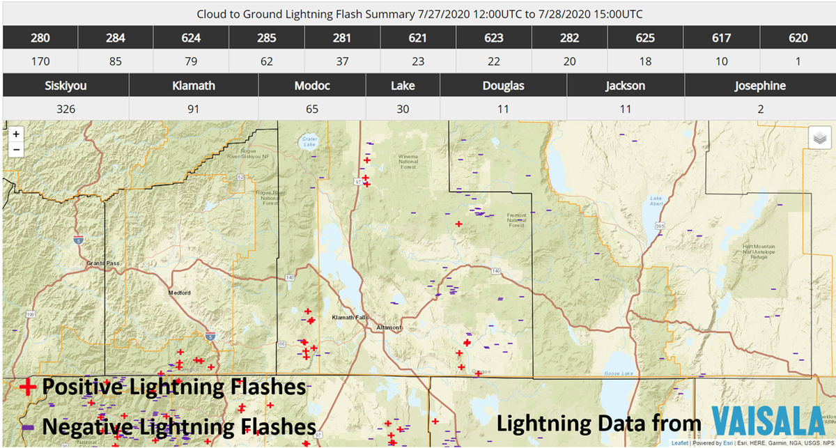
DYK: Positive lightning is particularly dangerous. It originates at the top of a thunderstorm, where cloud tops are positively charged and can strike as many as 25 miles away from its parent thunderstorm, where the ground is negatively charged.
Negative lightning originates from lower-level clouds in a thunderstorm and the bolts often strike directly under the thunderstorm where the ground is positively charged.
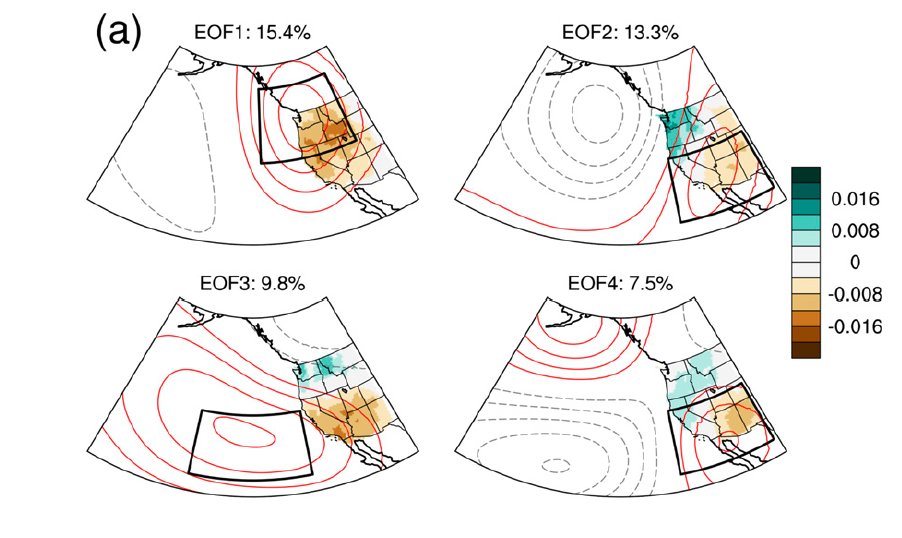
New work led by @SciGibson @NASAJPL! We take a deep dive into northeastern Pacific high pressure ridging, including trends, implications for California drought, #AtmosphericRiver activity, and possible underlying physical mechanisms. (1/6) #CAwx #CAwater journals.ametsoc.org/doi/full/10.11… 
Dry conditions with temperatures close to average for the time of year will ring in the first week of the new decade across California. Only a bit of light precipitation possible across far northern California. #CAwx 


Thereafter, a major pattern change will evolve around Jan 10. A strong blocking high pressure system will develop near Aleutian Islands, possibly leading to an Arctic outbreak across the West. A very cold and unsettled pattern may develop as a result. #CAwx 


Quite the video. Quite the caption #KOIN6News
A look at the little bit of mess left behind. That bolt ran down the length of the tree #orwx #KOIN6News 


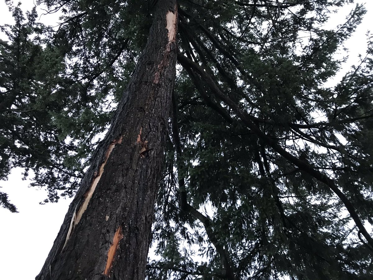
There’s also this just down the street. It looks like another branch caught the one that snapped, saving this car’s owner from any expensive repairs #orwx #KOIN6News 


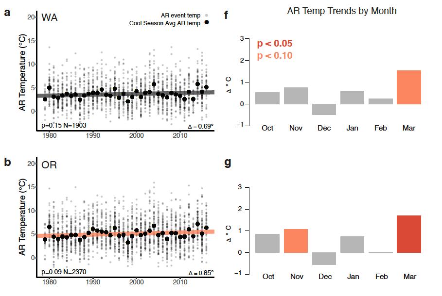
New research led by @k_r_gonz points to striking #AtmosphericRiver warming trend along U.S. West Coast in recent decades. We found that ARs have already warmed by > 2°C (3.6°F) in some months--faster than previous #climate projections had suggested. (1/8) agupubs.onlinelibrary.wiley.com/doi/10.1029/20… 
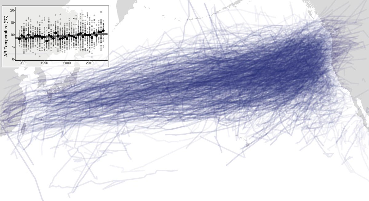
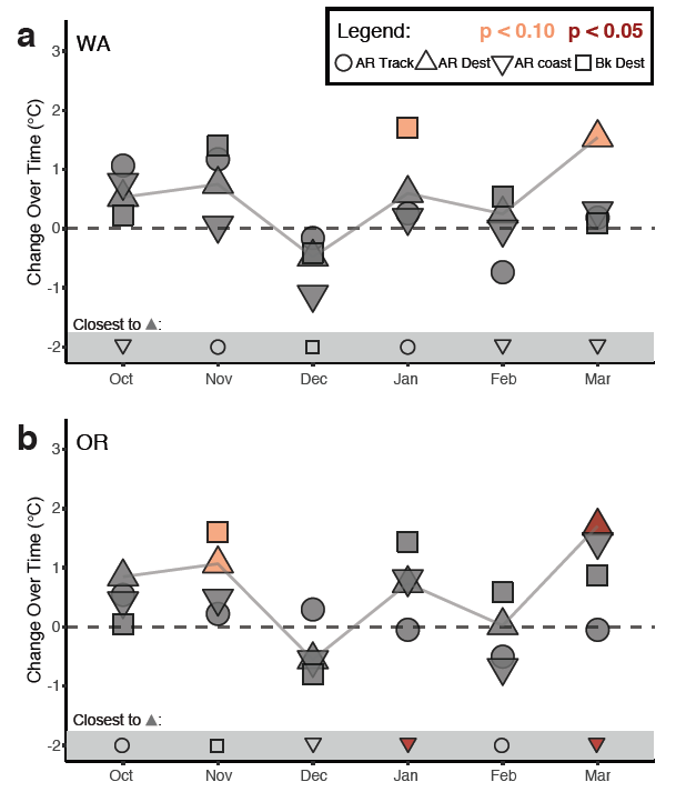
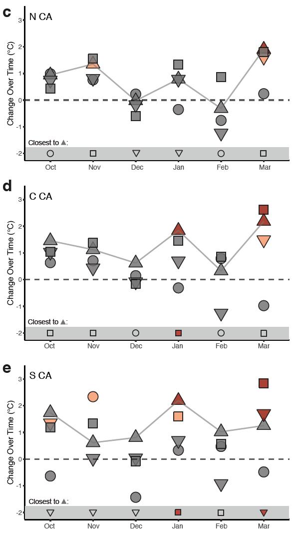
#AtmosphericRiver warming signal is robust in all regions during at least some months, including coastal Washington, Oregon, & California. But warming has been greatest in central & southern CA, especially during January & March. #CAwx #ORwx #WAwx (2/8) agupubs.onlinelibrary.wiley.com/doi/10.1029/20… 

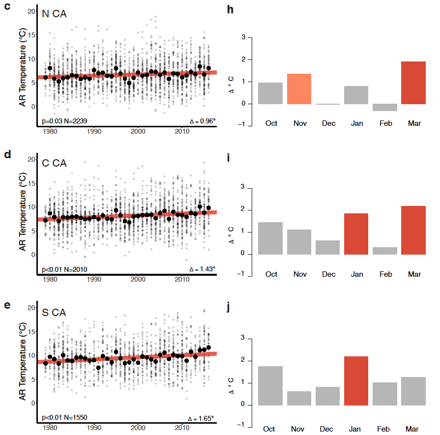
This #AtmosphericRiver warming appears to be driven by both local and geographically remote warming, but appears to scale most closely with near-shore ocean and local background (non-AR) temperature trends. (3/8) agupubs.onlinelibrary.wiley.com/doi/10.1029/20… 

The Clackamas River at Carver has spilled over its banks, creeping close to a few homes. People aren’t worried, though, and tell me they’ve seen it plenty higher #orwx #KOIN6News
Here’s a look at some area rivers @NWSPortland says are experiencing flooding or are expected to #orwx #KOIN6News 

In Estacada, Dubois Creek is pouring quite a bit of water into the Clackamas. The river sits well below homes here. It hit flood stage this evening near Milo McIver State Park #orwx #KOIN6News 

It’s been a day for Kelly. He’s been waiting for more than two hours (along with a lot of other drivers) to get home to Vancouver. He drives through 84 once a week and has never seen a backup like this. All we keep hearing is that WB lanes will open soon #orwx #KOIN6News 


UPDATE: Cars and semis are now slowly making their way back on to 84 WB. It looks like they’re having to get off at the city center exit and then get back on to 84 that way #orwx #KOIN6News
A sight for sore eyes #orwx #KOIN6News
