Discover and read the best of Twitter Threads about #CAwater
Most recents (24)
HAPPENING NOW! Join us as we explore the soil-water nexus and what it means for California's climate goals buff.ly/3HC1Zq5 

Dr. Sarah Castle welcomes everyone and gives a little more information about @SusCon_CA & our BRAND NEW soil health program
Thanks to our amazing sponsors @esassoc @Holland_Knight @IronHorseVyds & @SpottswoodeWine!
Thanks to our amazing sponsors @esassoc @Holland_Knight @IronHorseVyds & @SpottswoodeWine!
If you missed our first #webinar in our soils series, you can watch it right here
We accumulated 3.5" (9 cm) of #snow over the last 24 hours and it is expected to continue over the next couple days.
We've talked about snowfall totals and this year's move to second place, which is fantastic, but what about the water content of our snowpack? 🧵
#CAwx #CAwater
We've talked about snowfall totals and this year's move to second place, which is fantastic, but what about the water content of our snowpack? 🧵
#CAwx #CAwater

Above is a plot of Snow Water Equivalent (SWE; the amount of water that can come from melting the snowpack) from the @USDA_NRCS SNOTEL site at the Snow Lab. We can see that 2022/2023 currently has the highest SWE of any year back to 1984 for this date (69"; 175 cm). 🧵
However, 2010/2011 has the record for the greatest maximum SWE overall at 72.3" (184 cm). At the CSSL, our peak SWE generally occurs on March 24th and that is rapidly approaching. Given the short-term forecast, it's possible that we may fall behind 2010/2011 again. 🧵
Brief thoughts on likely return to active weather pattern in CA after a much-needed several day break right now. There is *high* confidence that wet and cool conditions will return next week, but right now there is *low* confidence in strength of storms. #CAwx #CAwater (1/4) 

I have never seen this type of #flood control measure before! Here is how some farmers deal with a breach in the Tulare Lake bottom. I assume they will pile some additional dirt on. #cawater #cawx #farm #agriculture
For all of those haters and doubters - here is what it looks like now - trees protected as well as community nearby. #cawater #flood #cawx #desperatemeasures #agriculture 

Brief thread about...snow. As of this weekend, the Southern Sierra now appears to have largest snowpack in recorded history (as measured by snow water equivalent, or SWE). Not just for the calendar date, but for *any* date! #CAwx #CAwater [1/n] 

A few storm updates following my session Wed PM:
Event still largely on track, but two modest shifts that could affect impacts:
1) Storm may not be quite as warm across central & northern Sierra; could see some very heavy snowfalls above 6,500 ft once again.
#CAwx #CAwater [1/5]
Event still largely on track, but two modest shifts that could affect impacts:
1) Storm may not be quite as warm across central & northern Sierra; could see some very heavy snowfalls above 6,500 ft once again.
#CAwx #CAwater [1/5]
2) Rainfall may be a bit heavier and more concentrated across the northern portion of central CA (but slightly less to north). This means flood risk in Monterey County (including Big Sur Coast), as well as southern Sierra & foothills, has increased somewhat. #CAwx [2/5]
3) Still not expecting widespread major river flooding. HOWEVER, localized significant flooding of creeks & streams is likely, and *possibly* on a few smaller rivers in the above-mentioned areas, due to combo of heavy rain & snowmelt below ~4,500ft elev. #CAwx [3/5]
The #snow over the weekend brought our total to 48.33 feet for the year, which is 0.56 feet above the 2016/2017 total of 47.77 feet. But, 2017 still has an advantage compared to this season: Snow Water Equivalent (SWE; water that comes from melting snow). 🧵
#CAwx #CAwater
#CAwx #CAwater

Due to our recent light snow, we have had less SWE accumulation than in the 2016/2017 winter, which means that we have less water available in the snowpack for use as it melts. In fact, we had 20% more SWE to this point in the season in 2017 (2017 - 65.3", 2023 - 54.4").
With more storms on the horizon, it's likely that we'll make up for this discrepancy and we may end up near or above the 2017 SWE max by the end of the season. Only time will tell though.
First cloud-free #Sentinel2 satellite images in a month dropped yesterday. Great to check out snow levels, reservoirs, and wet wet wet in the Butte Basin/Lower Sacramento River. First image compares Colusa area now vs 12/15/2022. #Geography #RemoteSensing #CaWx #CaStorm 1/x 


TODAY: @CaWaterBoards Voluntary Agreements Science Report Workshop 10:00 a.m.
CalEPA Building 1001 I Street, Sacramento
Watch VA Workshop youtube.com/user/BoardWebS…
Register for Public Comment
bit.ly/3kuCEp0
CalEPA Building 1001 I Street, Sacramento
Watch VA Workshop youtube.com/user/BoardWebS…
Register for Public Comment
bit.ly/3kuCEp0
The @CaWaterBoards staff has begun with their presentation on the Proposed #VoluntaryAgreements, including updates to the #BayDeltaPlan.
For folks emerging from retirement to champion big gulp for Delta tunnel (mostly older white men who ruled over #CAWater for decades) here are facts:
1) Doesn’t protect communities that will experience 100% of loss of life & 80% of economic loss.
1) Doesn’t protect communities that will experience 100% of loss of life & 80% of economic loss.
2) New intakes are not flood proof or protected from salt water intrusion. Our comments explain this. restorethedelta.org/wp-content/upl…
3) Exported water will lead to further groundwater depletion in Sac Valley.
🧵 As much as I've talked about our impressive snowpack in Utah (and it is VERY impressive), the numbers in the Southern Sierra are truly mind-boggling! #cawx #nvwx #cawater
Additional widespread precipitation is likely over the next 8-9 days over the northern 2/3 of CA, and it will be heavy at times (especially northern third of CA). Strongest storm, with some more heavy rain, wind, and thunderstorms, is due in on Sat. #CAwx #CAwater [1/4] 
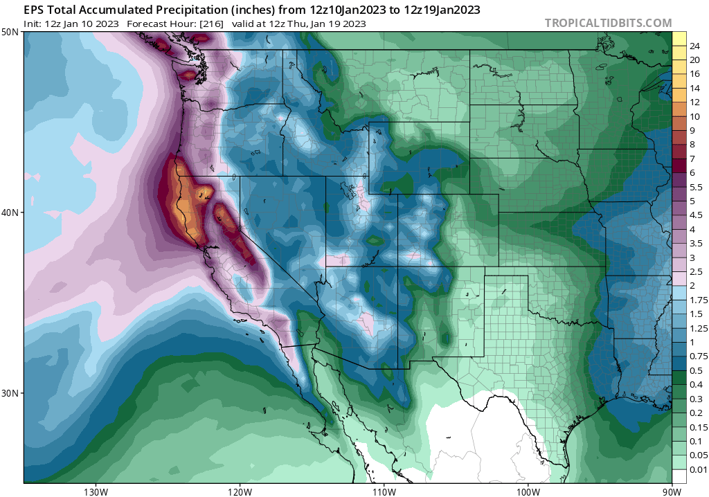
Okay, folks. Starting to look like it's going to be a rough 10+ days from a flood risk perspective in Northern California, with a series of very wet & high-impact storms. Brief thread now; blog post late this PM; YouTube live Q&A Tue. [1/n] #CAwx #CAwater
The next inbound storm looks like it will be quite strong. A rapidly deepening surface low (i.e., meteorological "bomb cyclone") will remain well offshore, but the associated warm and cold fronts will bring widespread heavy rain and strong winds to NorCal later Wed. #CAwx [2/n] 

This storm would be fairly notable in its own right, as it will be associated with an unusually well-defined warm *and* cold frontal passages and an exceptionally moist and relatively warm #AtmosphericRiver. #CAwater #CAwx [3/n] 

Some thoughts on impacts from ongoing and likely prolonged very wet spell in NorCal. (Short thread). TL;DR: widespread heavy precipitation is likely, with mostly minor flood issues becoming more widespread this weekend & *possibly* more significant next week. [1/n] #CAwx #CAwater
Latest seasonal predictions from NMME/IMME ensembles out today. Overall North Pacific pattern still looks very #LaNina-like: unusually wet PacNW and BC; unusually dry in SoCal & Lower Colorado Basin due to persistent NE Pacific ridging. HOWEVER... #WAwx #CAwx #AZwx (1/4) 

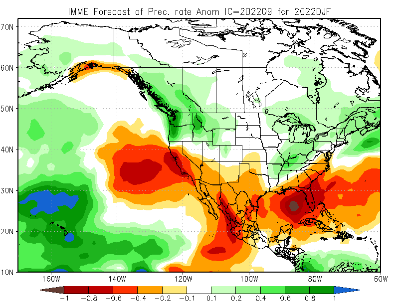

...However, exact position of N. Pac. ridge is key. Too far east, & CA stays dry, but far enough west & Sierra benefits from cold storms diving south. High confidence in winter ridge, but CA will be on razor's edge--exact position will dictate dry vs wet overall. (2/4)#CAwx
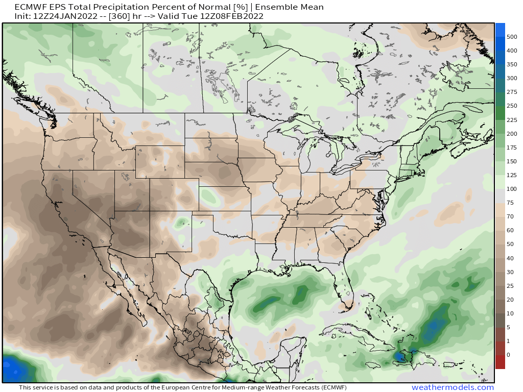
Some mixed news on CA weather front over next couple of weeks. First, by Monday, another "inside slider" system will bring another burst of cooler & winder conditions statewide. Once again, some Sierra snow showers are possible, but most places stay dry. #CAwx #CAwater 

Midweek, however, an even colder airmass and associated low pressure center will slide down the coast slightly farther to the west. This system, although still quite dry, stands a better chance of bringing convective activity (scattered showers/isolated thunder) statewide. #CAWx 


The biggest impact from this mid-week system, outside of some additional modest Sierra snow accumulations and a few pockets of accumulating small hail showers at lower elevations (like last week in SoCal), will be a dramatic shift toward much colder temperatures. #CAwx 
October and December were extremely wet in parts of California (record wet in some parts of NorCal). But the most recent ~45 day stretch (Jan 1-Feb 17) has been among driest mid-winter periods on record most of CA, NV, UT, and portions of adjacent states. #CAwx #CAwater (1/3) 

This has yielded in a seasonal "percent of average" precipitation map that is pretty misleading. Most of CA has slipped slightly below avg precip for the season to date--except for narrow swath along I-80 corridor that experienced the extreme Oct #AtmosphericRiver. #CAwx (2/3) 

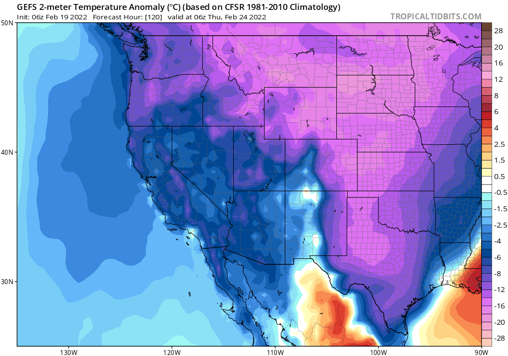
Very dry conditions will continue through end of month, bringing record dry January to some portions of Central & interior Northern CA/western NV. Multi-model ensembles are suggesting a subtle westward shift in Pacific blocking ridge in early February. However... #CAwx #CAwater 

However, that while westward shift in ridge axis may be enough to bring some colder & unsettled conditions, it's unlikely to be enough to offer more than light precip in most spots. And pattern shift may be short-lived, with ridging shifting back toward coast by mid Feb. #CAwx 
Interesting new analysis led by @ame_kaminari and co-authors including @epispheric demonstrating observed increases in hydroclimatic variability in California. *Increasing* 90th percentile in winter, but decreasing variability in autumn. rmets.onlinelibrary.wiley.com/doi/10.1002/jo… #CAwater
This offers some observational confirmation of climate model projections, which suggest that winter wet extremes will increase substantially with #ClimateChange even as shoulder season precipitation decreases and overall variability increases. #CAwater nature.com/articles/s4155…
Another reflection on @ame_kaminari's analysis: it is striking how many statistically robust changes are occurring to variability & seasonality of both precip & streamflow even when mean annual values change little. Yet another example of why averages can be misleading...#CAwater
California, on statewide basis, is now experiencing its worst drought in observational record going back to late 1800s--narrowly beating out peak of last drought in 2014-15 (as measured by PDSI, a metric that takes into account both precip & temperature). #CAwx #CAfire #CAwater 

There is a clear trend toward increasing aridity in California--and yet little trend in mean precipitation. How can this be? A very strong warming trend due to #ClimateChange means same the amount of water falling from sky just doesn't go as far as it used to. #CAwx #CAwater 


We explored this phenomena in research published in 2015 (finding that rising temps are the main factor behind increasing CA drought severity):
pnas.org/content/112/13…
and 2018 (increasing "precip whiplash" despite little change in mean):
nature.com/articles/s4155…
#CAwater #CAwx
pnas.org/content/112/13…
and 2018 (increasing "precip whiplash" despite little change in mean):
nature.com/articles/s4155…
#CAwater #CAwx
My perspective piece, "A shorter, sharper rainy season amplifies California wildfire risk," is now out in GRL. I discuss recent findings pointing toward shortening & sharpening wet season, & implications for ecology/wildfire. (1/17) #CAwx #CAfire #CAwater agupubs.onlinelibrary.wiley.com/doi/abs/10.102…
This perspective is in response to a recent analysis led by Jelena Luković showing that seasonal onset of CA precipitation has become progressively delayed (by ~1 month) in recent decades, w/ shorter but sharper rainy season. Underlying paper: agupubs.onlinelibrary.wiley.com/doi/full/10.10… (2)
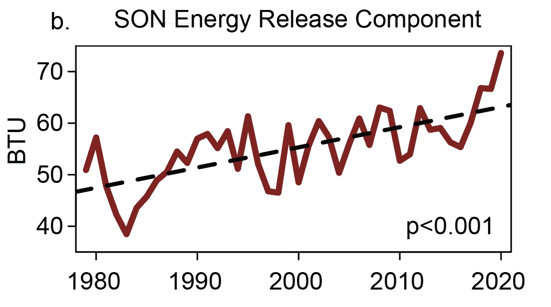
Record heat, plus late arrival of seasonal rains, have played a key role in CA's extremely severe wildfire seasons in recent years. Autumn 2020 exemplified this trend: vegetation conditions were, by a wide margin, the most flammable on record.#CAfire agupubs.onlinelibrary.wiley.com/doi/abs/10.102… (3) 


March 1st update: 2020-2021 "wet season" in California remains dismally dry in most places. In fact, wide swaths of both NorCal & SoCal are well under 50% of average precipitation. It has also been a warmer than average winter overall, despite some cold interludes. #CAwx #CAwater 


Statewide average snowpack has quickly fallen from late January highs (around 70-75% of average for the date) to around 61% of average for the date as of Mar 1. #CAwx #CAwater 

Outside of a brief period of possible showers across coastal SoCal on Wednesday, the next ~5 days still look very dry across most of CA. #CAwx 

In case you missed it: a "thread of threads" highlighting some of our collaborative research from 2020. How are wildfires, atmospheric rivers, floods, and other extreme events changing in a warming #climate (and in California specifically)? Read on for details: (1/8) #CAwater 

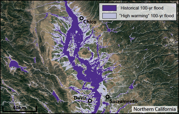
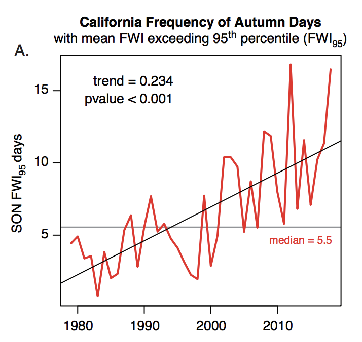
A general-audience primer on the rapidly advancing science of "extreme event attribution." How do scientists approach question of whether #ClimateChange is affecting likelihood and/or severity of extreme weather events? (2/8) @ClimateChirper @danielletouma
Our deep dive into extreme #AtmosphericRiver storms in California and how they are likely to warm & intensify considerably due to #ClimateChange. (3/8) @xingyhuang @ProfAlexHall
New research led by @ggpersad & featuring @PabloWater. Using downscaled climate model simulations, we show that there is unexpectedly high inter-model agreement re: increasing extremity of California hydroclimate due to #ClimateChange. (1/n) link.springer.com/article/10.100… #CAwater
In general, climate models agree than an increasing fraction of California's overall precipitation will become concentrated into the most intense events--and that the most extreme precip events will themselves be substantially more intense. (2/n) link.springer.com/article/10.100… #CAwater 
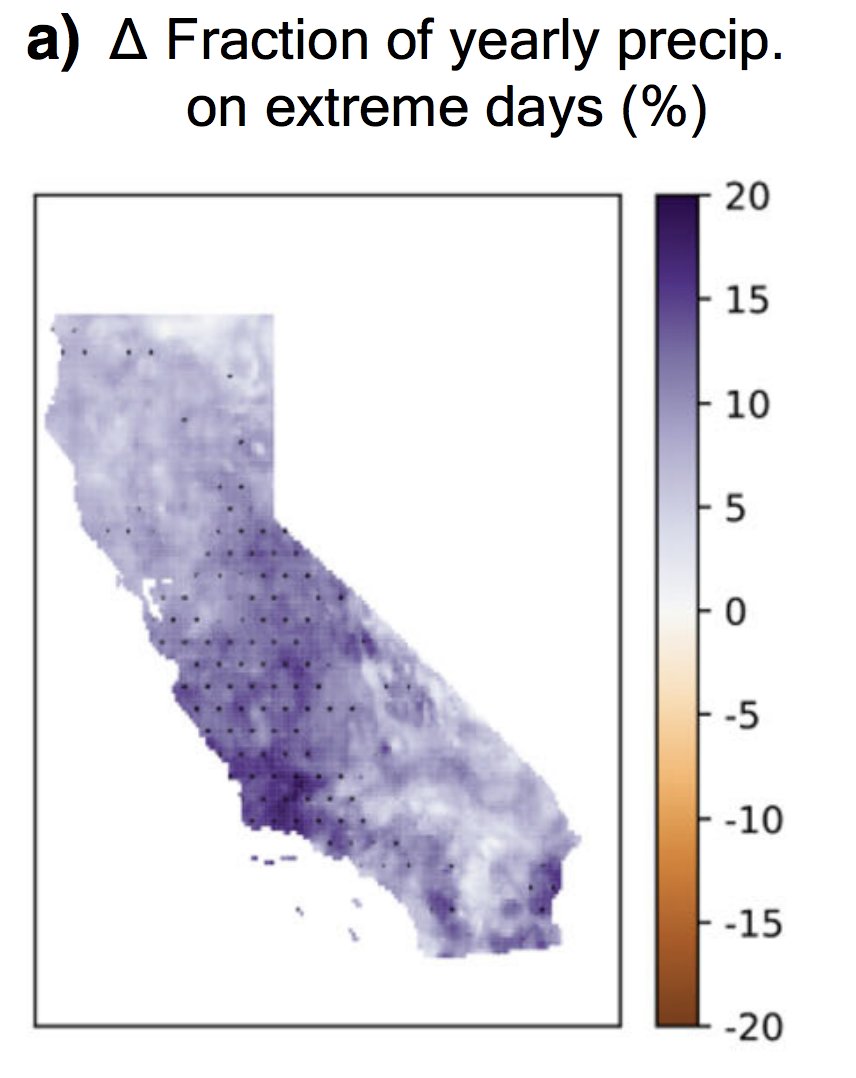
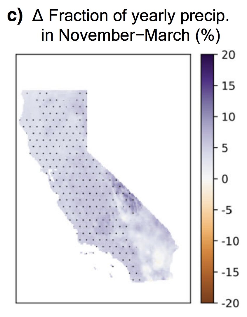
There is also agreement that CA's already pronounced precipitation seasonality will become even sharper--with more rain concentrated into winter months at expense of the autumn & spring. Consider the wildfire season implications... (3/n) link.springer.com/article/10.100… #CAwater #CAfire 
