Discover and read the best of Twitter Threads about #cawx
Most recents (24)
We accumulated 3.5" (9 cm) of #snow over the last 24 hours and it is expected to continue over the next couple days.
We've talked about snowfall totals and this year's move to second place, which is fantastic, but what about the water content of our snowpack? 🧵
#CAwx #CAwater
We've talked about snowfall totals and this year's move to second place, which is fantastic, but what about the water content of our snowpack? 🧵
#CAwx #CAwater

Above is a plot of Snow Water Equivalent (SWE; the amount of water that can come from melting the snowpack) from the @USDA_NRCS SNOTEL site at the Snow Lab. We can see that 2022/2023 currently has the highest SWE of any year back to 1984 for this date (69"; 175 cm). 🧵
However, 2010/2011 has the record for the greatest maximum SWE overall at 72.3" (184 cm). At the CSSL, our peak SWE generally occurs on March 24th and that is rapidly approaching. Given the short-term forecast, it's possible that we may fall behind 2010/2011 again. 🧵
Brief thoughts on likely return to active weather pattern in CA after a much-needed several day break right now. There is *high* confidence that wet and cool conditions will return next week, but right now there is *low* confidence in strength of storms. #CAwx #CAwater (1/4) 

I have never seen this type of #flood control measure before! Here is how some farmers deal with a breach in the Tulare Lake bottom. I assume they will pile some additional dirt on. #cawater #cawx #farm #agriculture
For all of those haters and doubters - here is what it looks like now - trees protected as well as community nearby. #cawater #flood #cawx #desperatemeasures #agriculture 

Brief thread about...snow. As of this weekend, the Southern Sierra now appears to have largest snowpack in recorded history (as measured by snow water equivalent, or SWE). Not just for the calendar date, but for *any* date! #CAwx #CAwater [1/n] 

#CAWX The U.S. Army Corps of Engineers Sacramento District is closely monitoring Isabella Dam and Lake in connection with the ongoing severe weather event.
Current projections of snowmelt volume as a result of these storms are well within the capacity of Isabella Lake.
Current projections of snowmelt volume as a result of these storms are well within the capacity of Isabella Lake.
We estimate that reservoir volume at the conclusion of this event will be between 230,000 and 270,000 acre-feet. The overall capacity of Isabella Lake is 568,000 acre-feet. We are coordinating with our state and local partners to update our projections multiple times a day.
If current projections hold, we will not need to use either the service or emergency spillways. We plan to use the outlet works located below the crest of the main dam for any increased outflows, which will be coordinated in advance with downstream water users.
A few storm updates following my session Wed PM:
Event still largely on track, but two modest shifts that could affect impacts:
1) Storm may not be quite as warm across central & northern Sierra; could see some very heavy snowfalls above 6,500 ft once again.
#CAwx #CAwater [1/5]
Event still largely on track, but two modest shifts that could affect impacts:
1) Storm may not be quite as warm across central & northern Sierra; could see some very heavy snowfalls above 6,500 ft once again.
#CAwx #CAwater [1/5]
2) Rainfall may be a bit heavier and more concentrated across the northern portion of central CA (but slightly less to north). This means flood risk in Monterey County (including Big Sur Coast), as well as southern Sierra & foothills, has increased somewhat. #CAwx [2/5]
3) Still not expecting widespread major river flooding. HOWEVER, localized significant flooding of creeks & streams is likely, and *possibly* on a few smaller rivers in the above-mentioned areas, due to combo of heavy rain & snowmelt below ~4,500ft elev. #CAwx [3/5]
The #snow over the weekend brought our total to 48.33 feet for the year, which is 0.56 feet above the 2016/2017 total of 47.77 feet. But, 2017 still has an advantage compared to this season: Snow Water Equivalent (SWE; water that comes from melting snow). 🧵
#CAwx #CAwater
#CAwx #CAwater

Due to our recent light snow, we have had less SWE accumulation than in the 2016/2017 winter, which means that we have less water available in the snowpack for use as it melts. In fact, we had 20% more SWE to this point in the season in 2017 (2017 - 65.3", 2023 - 54.4").
With more storms on the horizon, it's likely that we'll make up for this discrepancy and we may end up near or above the 2017 SWE max by the end of the season. Only time will tell though.
(1/4) Here is our preliminary thoughts on the timing and intensity of the precipitation for the rest of this week. Off-and-on rain showers will be possible from late tonight through Thursday with light accumulations. Heavier and more widespread precip develops Thursday afternoon. 

(2/4) For Thursday through Saturday, an atmospheric river takes aim at Southern California, leading to widespread moderate to heavy rain, with the heaviest expected to occur on Friday. Heavy mountain snow will also be possible Thu-Sat, generally above 5000 feet.
(1/4) ⚠️ HAZARDOUS TRAVEL IN THE MOUNTAINS THIS WEEK ⚠️ winds will rapidly increase this evening and peak overnight in the mountains. Snow levels will crash tomorrow morning, potentially as low as 2000 feet. READ THE WHOLE TWEET THREAD BELOW: 

(2/4) PLEASE NOTE: The snow accumulation graphic is only for snow accumulations through Thursday morning. ADDITIONAL HEAVY SNOW, ON THE ORDER OF SEVERAL FEET OF SNOW, WILL BE POSSIBLE THURSDAY NIGHT THROUGH SATURDAY.
(3/4) Winter Weather Advisories have been issued for LOCATIONS ABOVE 2500 FEET in the Inland Empire, and for LOCATIONS ABOVE 2000 FEET in the San Diego County Valleys through Thursday morning. Winter Storm Warnings are in effect for the mountains through Saturday.
Lot of hype right now regarding supposed potential for widespread "sea level snowfall" later next week NorCal.
That almost certainly isn't going to happen (for variety of reasons). But some unusually low elevation snowfall (to 1000-1,500 feet or so) is certainly possible. #CAwx
That almost certainly isn't going to happen (for variety of reasons). But some unusually low elevation snowfall (to 1000-1,500 feet or so) is certainly possible. #CAwx
Yes, I know that the coarse-resolution ensemble models are showing accumulating sea level snowfall for SF/Sacramento. They are very likely wrong--and the same models' *own thermal profiles* are not supportive of snow in these areas with this pattern! #CAwx
It is *extremely* difficult to generate widespread snowfall to sea level in central/northern CA. Very cold air aloft sometime happens, but getting the freezing level all the way to the surface takes an exceptional weather pattern. #CAwx
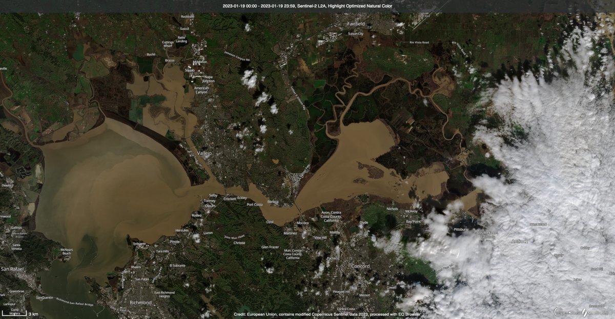
First cloud-free #Sentinel2 satellite images in a month dropped yesterday. Great to check out snow levels, reservoirs, and wet wet wet in the Butte Basin/Lower Sacramento River. First image compares Colusa area now vs 12/15/2022. #Geography #RemoteSensing #CaWx #CaStorm 1/x 


🧵 As much as I've talked about our impressive snowpack in Utah (and it is VERY impressive), the numbers in the Southern Sierra are truly mind-boggling! #cawx #nvwx #cawater
Additional widespread precipitation is likely over the next 8-9 days over the northern 2/3 of CA, and it will be heavy at times (especially northern third of CA). Strongest storm, with some more heavy rain, wind, and thunderstorms, is due in on Sat. #CAwx #CAwater [1/4] 
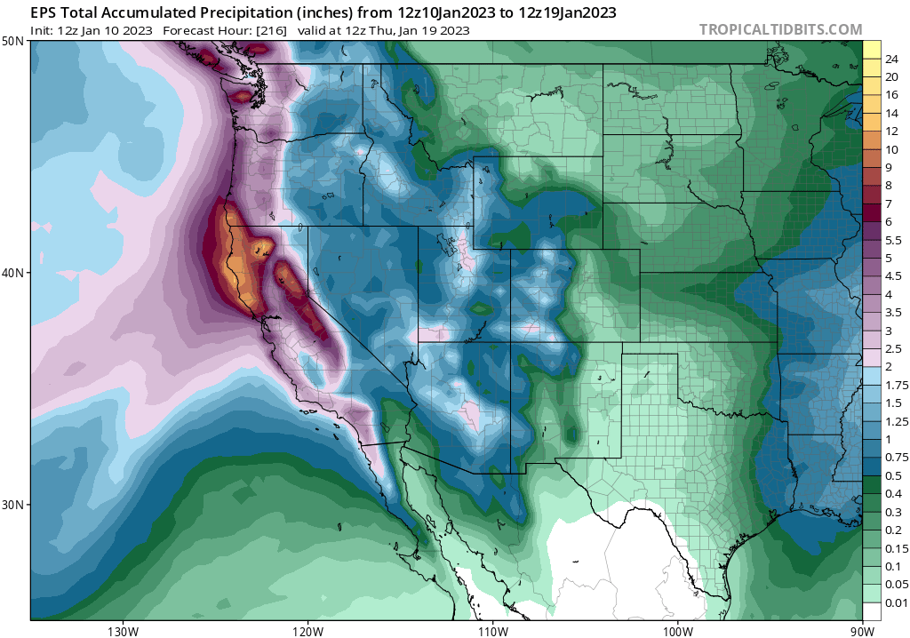
(1/8) We have quite the storm this week. We will lay out the impacts in this order:
1. Rain and Flooding
2. Wind
3. Snow
4. Hazardous Marine Conditions
Please read through the full thread & know that we are always looking at/updating the forecast as we get new information.
#CAwx
1. Rain and Flooding
2. Wind
3. Snow
4. Hazardous Marine Conditions
Please read through the full thread & know that we are always looking at/updating the forecast as we get new information.
#CAwx

(1/5) After a quiet weekend weather-wise, the next in a series of storm systems will begin to impact SoCal next week. Widespread moderate to heavy rain (with a slight chance of t-storms) and very strong winds can be anticipated. The heaviest precip is expected across SBCo Mtns. 

(2/5) Rain may develop as early as Mon morning across Orange/San Bernardino Counties, with light rain spreading southeastward through the day. However, an increase in activity is expected through Monday night, with with heaviest and most widespread rain occurring on Tuesday. 

(3/5) The @NWSWPC is outlooking a SLIGHT RISK for excessive rain leading to flash flooding across portions of Orange, San Bernardino and Riverside Counties. Rain rates could be very high in the strongest cells, so remain alert for flooding. 

Okay, folks. Starting to look like it's going to be a rough 10+ days from a flood risk perspective in Northern California, with a series of very wet & high-impact storms. Brief thread now; blog post late this PM; YouTube live Q&A Tue. [1/n] #CAwx #CAwater
The next inbound storm looks like it will be quite strong. A rapidly deepening surface low (i.e., meteorological "bomb cyclone") will remain well offshore, but the associated warm and cold fronts will bring widespread heavy rain and strong winds to NorCal later Wed. #CAwx [2/n] 

This storm would be fairly notable in its own right, as it will be associated with an unusually well-defined warm *and* cold frontal passages and an exceptionally moist and relatively warm #AtmosphericRiver. #CAwater #CAwx [3/n] 

(1/4) The first week of 2023 looks quite stormy! After rain diminishes tonight, the next chance for widespread rain looks to develop tomorrow night-Tue morning. The rain isn't expected to be as heavy as last night, but widespread accumulations are expected. 

(2/4) Rain will increase from northwest to southeast Monday night. Preliminary rain totals are as follows:
Coast: 0.50-0.75"
Valleys: 0.40-0.75"
Mountains: 0.50-1.00"
Deserts: 0.01-0.20"

Coast: 0.50-0.75"
Valleys: 0.40-0.75"
Mountains: 0.50-1.00"
Deserts: 0.01-0.20"

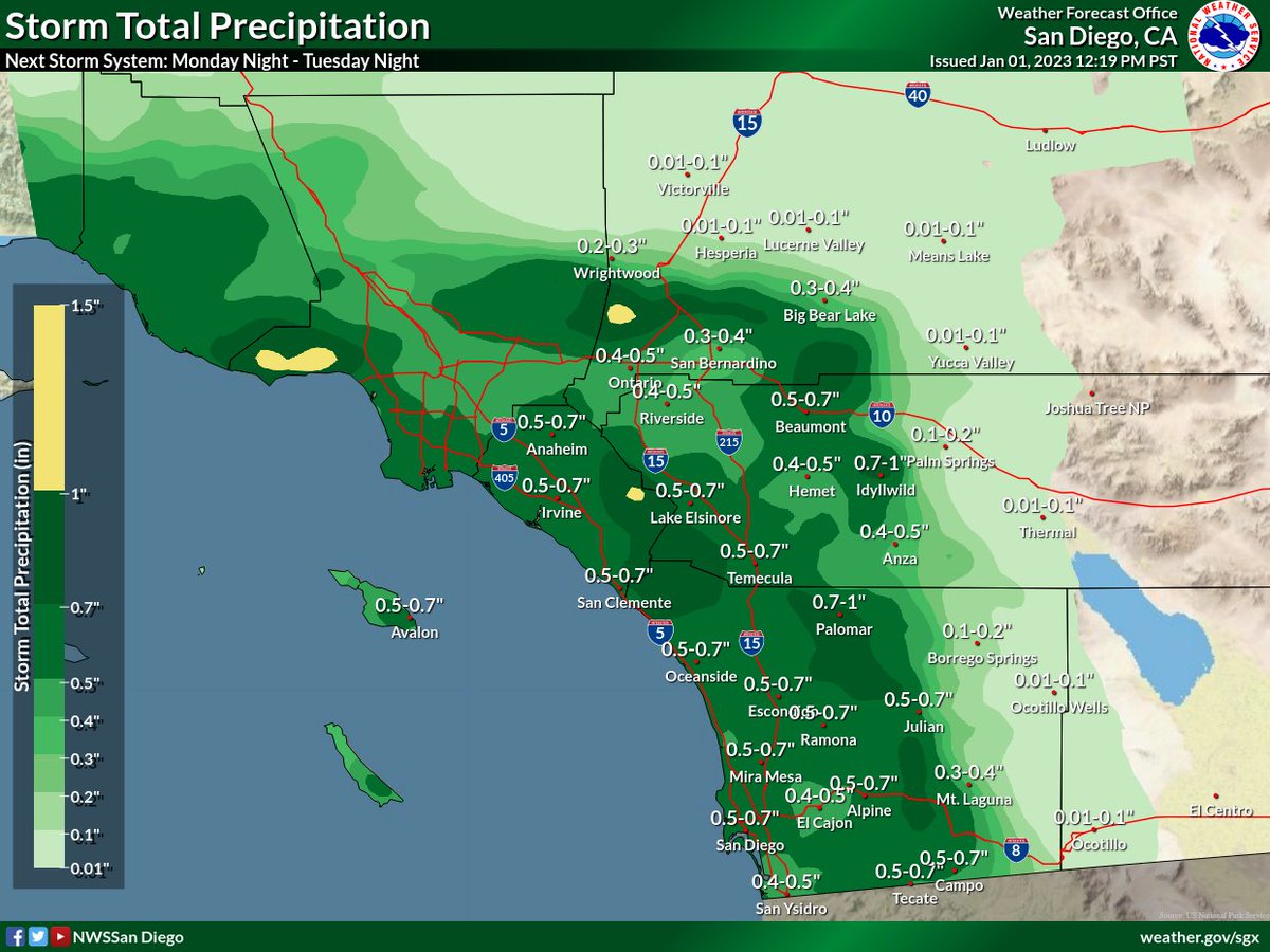
(3/4) Another, and potentially significant storm system, looks to move into Southern California late this week. Rain amounts are uncertain at this time, but could be significant. Tune in over the next few days as we refine the forecast!
#CAwx
#CAwx

2023 is bringing us an #AtmosphericRiver for its arrival! Because 280 characters is never enough to summarize these, here's another 🧵of our updates and what we're expecting! #CAwx (1/6)
We've hoisted a Flood Watch for tomorrow evening given the potential for widespread rainfall everywhere from the mountains westward. Use extra caution if you're out and about! Travel will be dangerous given rain, lots of folks on the road, and... other reasons🥴#IYKYK #CAwx (2/6) 


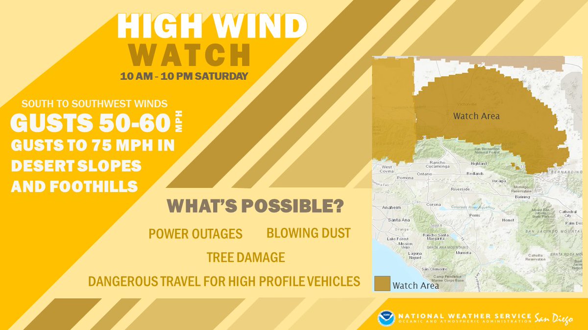
It'll also be windy during the daytime on Saturday, the kinda wind that likes to transport trash cans, unsecured holiday decor, and other loose objects. Use caution if traveling in a high-profile vehicle as well. #CAwx (3/6) 


Some thoughts on impacts from ongoing and likely prolonged very wet spell in NorCal. (Short thread). TL;DR: widespread heavy precipitation is likely, with mostly minor flood issues becoming more widespread this weekend & *possibly* more significant next week. [1/n] #CAwx #CAwater
The @NWSCPC Winter 22-23 Outlook is out!
🌡️Odds tilt toward above-normal temps across much of California
🌧️There are equal chances for precip to be above, below, or near normal across NorCal
*This outlook was heavily influenced by La Niña conditions remaining thru winter (1/4)
🌡️Odds tilt toward above-normal temps across much of California
🌧️There are equal chances for precip to be above, below, or near normal across NorCal
*This outlook was heavily influenced by La Niña conditions remaining thru winter (1/4)

Latest seasonal predictions from NMME/IMME ensembles out today. Overall North Pacific pattern still looks very #LaNina-like: unusually wet PacNW and BC; unusually dry in SoCal & Lower Colorado Basin due to persistent NE Pacific ridging. HOWEVER... #WAwx #CAwx #AZwx (1/4) 

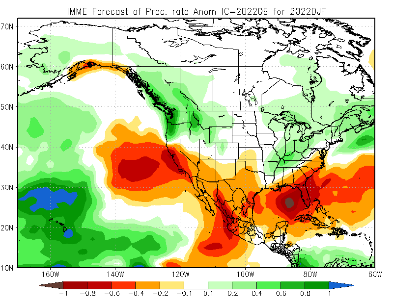

...However, exact position of N. Pac. ridge is key. Too far east, & CA stays dry, but far enough west & Sierra benefits from cold storms diving south. High confidence in winter ridge, but CA will be on razor's edge--exact position will dictate dry vs wet overall. (2/4)#CAwx
Lot of attention today focused on SW flank of #MosquitoFire near Foresthill, but eastern flank is also very active today. With upcoming period of SW winds--perhaps getting pretty strong over weekend--there is *possibility* it could run upslope toward Tahoe Basin. #CAwx #CAfire
.@wildland_zko & others have been thoughtfully considering this possibility for some days. With today's resurgence in activity, plus upcoming weather (SW winds, perhaps strong this wknd), & given now record dryness of heavy (100-1000hr) fuels, this is within realm of possibility.
Source for that "record dryness" claim: here's the 1000hr fuel moisture chart for the Northern Sierra PSA as of today. 100hr FM, 1000hr FM, and ERCs all at record levels for date and essentially tied with all-time, any date records. #CAfire 

The coming week is shaping up to be a pretty crazy weather week in California, TBH--even more so than previously thought. Ongoing heatwave expected to be longer & peak even higher, & now we have potential influence of a soon-to develop hurricane to consider. (1/n) #CAwx #CAfire 

First, exceptional daytime & nighttime heat (plus high humidity) continues across SoCal today. Some places may see all-time record warmest overnight temps today. In northern California, much drier heat is building,& temperatures will continue to rise further for days. (2/n) #CAwx
Any stats nerds out there?🤓🙋
a thread...🧵#CAwx #CAheat
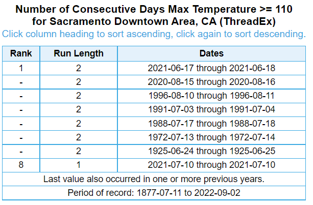
Let's dive deep into Downtown Sac's record book, which goes back to 1877.
Of all days' high temps in the record book (N=53015)
▪️4.0% (n=2114) were ≥100°F
▪️0.9% (n=479) were ≥105°F
▪️0.06% (n=34) were ≥110°F
...1/4
a thread...🧵#CAwx #CAheat
Let's dive deep into Downtown Sac's record book, which goes back to 1877.
Of all days' high temps in the record book (N=53015)
▪️4.0% (n=2114) were ≥100°F
▪️0.9% (n=479) were ≥105°F
▪️0.06% (n=34) were ≥110°F
...1/4


