Discover and read the best of Twitter Threads about #WAwx
Most recents (24)
ICE STORM ARRIVES LATE THURS: Getting a lot of questions about the pending ice storm for n.w. Oregon & s.w. Washington. This thread should answer some q’s, including:
1) When will it turn icy?
2) How much ice will accumulate?
3) Roughly when will it thaw out?
#PDX #ORwx #WAwx
1) When will it turn icy?
2) How much ice will accumulate?
3) Roughly when will it thaw out?
#PDX #ORwx #WAwx
Between this afternoon & eve, modified arctic air will surge through the Gorge & spread across the Portland metro area. Temps will drop into the 20s & teens / wind chills in the single digits & maybe below zero. Cold air spreads across western valleys & coastline tonight.
Ice will begin to accumulate late Thurs. By Friday A.M., most surfaces will be glazed over. Populated areas up & down I-5 corridor could pick up ~ 1/10-1/4” of ice. Lots of power outages expected. Pockets of Coast Range, metro area, Cascades & Gorge could see 1/4-1/2”+ of ice.
ICE STORM A FEW DAYS AWAY: The coldest air of the season will spread west of the Cascades between late Wednesday & early Thurs. Many cities in our western valleys will be locked in by freezing air through at least Fri. Temps will gradually warm up this weekend. #PDX #ORwx #WAwx
Initially, cold air will spread all the way down the Willamette Valley & out along the northern Oregon & southern Washington Coast. Eventually, a warmer weather system will erode the cold air away, first along coast, then southern valley, & last in metro area. #PDX #ORwx #WAwx
Precipitation will begin to spread inland Thurs. afternoon, w/ steadier precip. Thursday night. Anything that falls in Coast Range, interior valleys and points to the east will either be snow, a wintry mix or freezing rain. Roads will turn nasty overnight Thurs eve/night.
The Portland/Vancouver metro area is ~ 3 days out from COLD air arriving, and about 4-5 days out from snow transitioning to freezing rain. Ice storm possible Friday. Will know more by Tue/Wed regarding how much snow/ice is coming and who could get hit hardest. #PDX #ORwx #WAwx 

Let’s go over what we know: arctic air will pour across the interior Northwest Wednesday, and will spread west of the Cascades Wednesday night / Thursday A.M.
It won’t be quite as cold west of Cascades as it will be to the east, but still.. prepare for widespread teens & low 20s w/ lower wind chills. Most of Wed/Thurs. will be dry. Warmer moist air will overrun cold air starting Thursday night - Friday A.M. = turning messy in lowlands.
Happy Sunday, all! Wanted to give everyone as much of a heads up as possible about this week, since many will be traveling in the days leading up to Christmas. Some kind of snow/ice event is possible in the Portland metro area, Gorge & Cascade Foothills Thur-Sat. #PDX #ORwx #WAwx 

WEDNESDAY: Starting in afternoon / evening, a cold east wind will be cranking thru the Gorge and across the Portland / Vancouver metro area. This modified arctic air will prime the region with sub-freezing air, setting the stage for a winter weather event Thursday/Friday. #PDX 

THURSDAY: By Thursday morning, our temperatures will be well below freezing, somewhere between the mid teens and low 20s. Due to the strong east wind, temperatures will likely stay below freezing all day long. Colder in Gorge. Precip. will arrive from the west Thursday P.M.
Latest seasonal predictions from NMME/IMME ensembles out today. Overall North Pacific pattern still looks very #LaNina-like: unusually wet PacNW and BC; unusually dry in SoCal & Lower Colorado Basin due to persistent NE Pacific ridging. HOWEVER... #WAwx #CAwx #AZwx (1/4) 

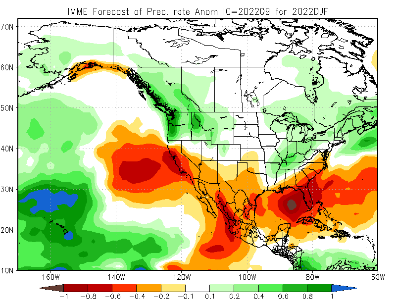

...However, exact position of N. Pac. ridge is key. Too far east, & CA stays dry, but far enough west & Sierra benefits from cold storms diving south. High confidence in winter ridge, but CA will be on razor's edge--exact position will dictate dry vs wet overall. (2/4)#CAwx
The @NHC_Atlantic has asked us to do 6 hour balloon launches for the next several days to help forecast/support Tropical Cyclone Ian. This is the closest we have ever been to hurricane forecasting! We are excited! Why have they asked us? Standby for an explanation. #wawx #idwx
Everything is connected. Stuff that happens across the Pacific Northwest has implications and impacts of what happens downstream i.e. how things evolve across the southeast US. #wawx #idwx
Here is another model. See the differences in the evolution & track of Ian? This is why extra balloon flights are helpful, bc the data gets ingested into every model run to help forecast Ian's track & help the models become consistent with better data #wawx #idwx @CoDWXData
Incessant heavy rain will pile into the Pacific Northwest, USA 🇺🇸 & British Columbia, Canada 🇨🇦 in the next 72 hours due to a significant atmospheric river event.
Flooding & landslides are highly likely. The atmospheric warmth & moisture can be traced all the way to the tropics.
Flooding & landslides are highly likely. The atmospheric warmth & moisture can be traced all the way to the tropics.
A strong meander in the jet stream allows Alaska to cool under Arctic air but also helps lift Tropical warmth & moisture into British Columbia & the Pacific Northwest.
Notice how the atmospheric moisture aligns and focuses on the same area. This is like nature's firehose. Extreme rain and locally very high freezing levels expected. Meteorologists call this an atmospheric river.
Some refer to this atmospheric river as 'the Pineapple Express'.
Some refer to this atmospheric river as 'the Pineapple Express'.
Current forecast highs & records for Thursday, August 12th:
Seattle: 94 (96 in 1977)
Olympia: 99 (96 in 1977)
Quillayute: 86 (90 in 2002)
Hoquiam: 81 (84 in 2016)
Bellingham: 90 (85 in 1977)
Continued...
Seattle: 94 (96 in 1977)
Olympia: 99 (96 in 1977)
Quillayute: 86 (90 in 2002)
Hoquiam: 81 (84 in 2016)
Bellingham: 90 (85 in 1977)
Continued...
Current forecast highs & records for Friday, August 13th:
Seattle: 95 (92 in 2002)
Olympia: 97 (94 in 1967)
Quillayute: 80 (92 in 2002)
Hoquiam: 75 (89 in 2002)
Bellingham: 87 (90 in 2010)
One more time...
Seattle: 95 (92 in 2002)
Olympia: 97 (94 in 1967)
Quillayute: 80 (92 in 2002)
Hoquiam: 75 (89 in 2002)
Bellingham: 87 (90 in 2010)
One more time...
...And finally, the current forecast highs & records for Saturday, August 14th:
Seattle: 91 (95 in 2010)
Olympia: 90 (95 in 2010)
Quillayute: 75 (96 in 2010)
Hoquiam: 71 (86 in 2018)
Bellingham: 83 (88 in 2010)
Temps "cool" into 70s to mid 80s starting Sunday. #wawx
Seattle: 91 (95 in 2010)
Olympia: 90 (95 in 2010)
Quillayute: 75 (96 in 2010)
Hoquiam: 71 (86 in 2018)
Bellingham: 83 (88 in 2010)
Temps "cool" into 70s to mid 80s starting Sunday. #wawx
As you can see on the map at weather.gov excessive heat watches are now up for later this week. Here in Western WA it will be hot Thursday through Saturday (but not as hot as it was at the end of June). Here in Seattle we should see three days in the lower to mid 90s. 

Here are some specifics on the temperature ranges for the bulk of the heat wave. The main caveat of course, would be the impact of upper level smoke and haze. In the next tweet, you'll see the chances of records being tied or exceeded. #wawx 


Here are the chances of records being tied or broken on Friday and Saturday at a few locations. The daily record at SeaTac on the 13th is 92 (2002) and 95 on the 14th (2010). #wawx 


STATE RECORD?! (1 of 3)
Multiple stations in Washington state yesterday recorded high temperatures that potentially tied or exceeded the all-time record high for the state of 118°F. #wawx
Multiple stations in Washington state yesterday recorded high temperatures that potentially tied or exceeded the all-time record high for the state of 118°F. #wawx
STATE RECORD?! (2 of 3)
In Western Washington this includes three stations: 118 at Sol Duc River near Forks, 118 at Mayfield Power Plant in Lewis County, and 120 near Renton. #wawx
In Western Washington this includes three stations: 118 at Sol Duc River near Forks, 118 at Mayfield Power Plant in Lewis County, and 120 near Renton. #wawx
STATE RECORD?! (3 of 3)
We will be participating in the State Climate Extremes Committee & conducting initial investigations of the sites & equipment locations. Representatives from @NWSPortland @NWSPendleton & @NWSSpokane will be doing similar investigations in their areas #wawx
We will be participating in the State Climate Extremes Committee & conducting initial investigations of the sites & equipment locations. Representatives from @NWSPortland @NWSPendleton & @NWSSpokane will be doing similar investigations in their areas #wawx
Alright everyone, let's discuss the active weather pattern for this week. Here are the main areas of focus:
🌨️Lowland Snow
🥶Cold Temperatures & Wind Chill
🌬️Locally Strong Winds
🌨️Lowland Snow
🥶Cold Temperatures & Wind Chill
🌬️Locally Strong Winds
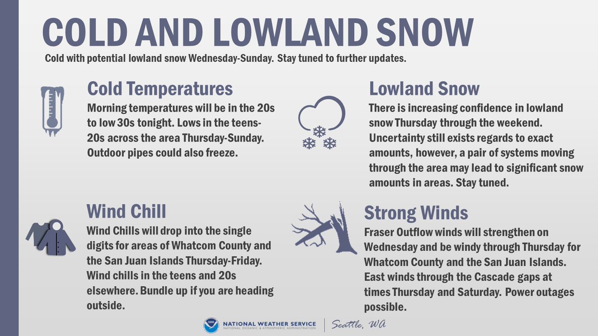
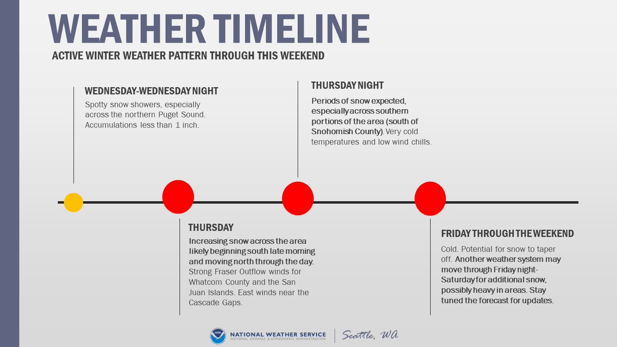
The active weather pattern is expected from Wednesday through the weekend. Spotty snow showers Wednesday, with increasing snow Thursday morning. The potential exists for another round of snow Friday night into the weekend. However, there is uncertainty in the forecast. #WAwx 
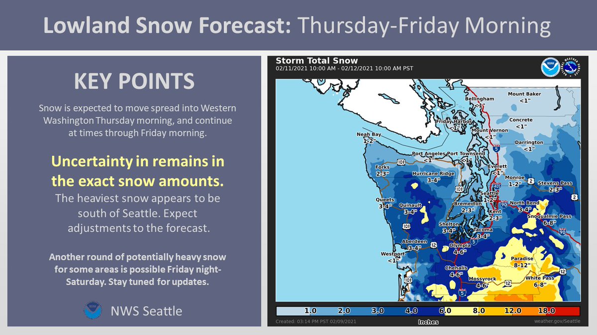
First call snow map for Thursday-Friday Morning:
Confidence is increasing in lowland snow for Thursday-Friday morning. Expect some adjustment to these snow amounts as we approach the event. Another round of snow potentially Friday night into the weekend. #WAwx
Confidence is increasing in lowland snow for Thursday-Friday morning. Expect some adjustment to these snow amounts as we approach the event. Another round of snow potentially Friday night into the weekend. #WAwx
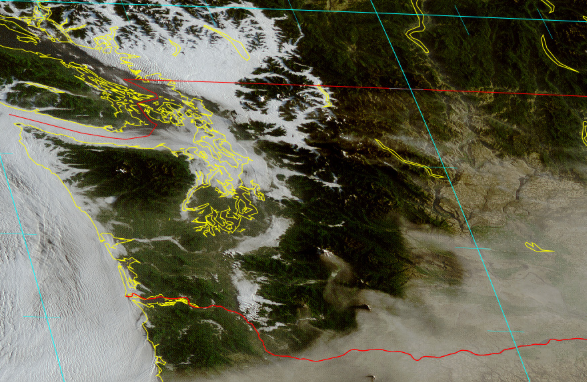
Sure, it's chilly out there, but it'll get colder. Here's a hand drawn map over a satellite image taken from the NOAA 20 polar orbiting satellite today. A weak system moving south through B.C. with a give a modified arctic front a shove southward tomorrow. 

That's the precursor to more interesting weather later Thursday into Saturday. Outflow finds through the Fraser River Valley will increase substantially by Thursday - which provides Western WA with additional (and colder) air.
Moisture arriving from our southwest on Thursday will "overrun" the cold air in place - and that's the final ingredient for snow. On a side note, the yellow arrows point to "cloud streets" formed by the chilly air escaping B.C.'s interior.
[🥶THREAD] We hit on snow in a thread earlier so now let's talk COLD! Much colder air is on the way for the rest of the weekend with the coldest temperatures mid to late week. Overnight lows will likely drop below freezing, into the teens and 20s for many locations. #wawx
While we're confident it'll be some of the coldest air we've seen this winter, this is still uncertainty in just how low temperatures may drop! Here's a look at the ranges we might see by Friday morning! #wawx 

In addition to the cold - gusty northeast winds from the Fraser River Valley near the Canadian border are expected to flow into western Whatcom, Skagit, and the San Juans. Need a refresher on Fraser Outflow? Check out this video: #wawx
[THREAD] First up for our afternoon forecast updates is the lowland snow potential! We'll post another thread with info on the cold later so it's easier to keep it all straight! 🥶 #wawx
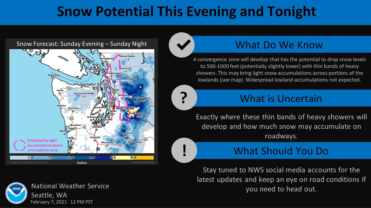
A convergence zone will develop this evening - tonight that has the potential to drop snow levels to 500-1000 feet (potentially slightly lower) with thin bands of heavy showers. This may bring light snow accumulations across portions of the lowlands - see graphic. #wawx 
So what's still uncertain?
❄️Exactly where these thin bands of heavy showers will develop
AND
❄️How much snow may accumulate on roadways given above freezing temperatures
We'll certainly have frequent updates here as things develop so stay tuned! #wawx
❄️Exactly where these thin bands of heavy showers will develop
AND
❄️How much snow may accumulate on roadways given above freezing temperatures
We'll certainly have frequent updates here as things develop so stay tuned! #wawx
We've got a lot weather-wise coming our way into Wednesday. So how about a quick thread with the details to kick off the work week? Rain, Flooding, Landslides, Snow, Wind, & Coastal Hazards - we've got it all! Keep it tuned here throughout the storm! #wawx 

Rain is moving onshore this morning & will continue at times thru Weds. Heaviest tonight - Tues AM & again Tues night - Weds AM. Snow levels will rise. This brings about the potential for urban, small stream, & river flooding. The threat for landslides returns as well. #wawx 

Speaking of snow levels - warmer air will invade, rising snow levels above the passes Tuesday. But not before the storm drops some snow at pass level! If you have travel plans over the Cascades, give @wsdot a follow and check road conditions at: wsdot.com/traffic/passes #wawx 

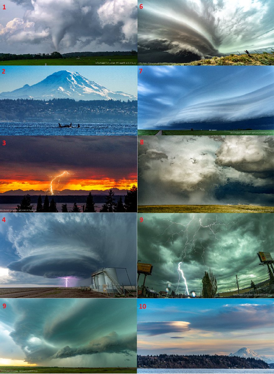
#wawx My top 10 shots of 2020. Comment on which is your favorite and if this post gets 300 likes I'll send a framed print of your favorite picture! 
Well it looks like fall is going to waste no time making its presence known! A weather system will bring widespread rain - heavy in spots - and wind to the area Wednesday with showers continuing through at least Friday! Here's a short thread with the details! #wawx 

Wondering how much rain we'll see on Wednesday through early Thursday? Take a look at our latest forecast! Additional rain (not depicted here) expected for the end of the week with isolated thunderstorms also a possibility Thursday & Friday. #wawx 

Along with the rain, Wednesday's system will also bring some gusty winds with it. Highest winds expected along the coast. Localized power outages & tree damage possible as trees still have most of their leaves on! #wawx 

Convective weather models and smoke: A Thread!
Situations involving the potential for thunderstorms and the backdrop of thick smoke are complicated for a few reasons! The first being that most convective models do not consider smoke in their initialization. #wawx
Situations involving the potential for thunderstorms and the backdrop of thick smoke are complicated for a few reasons! The first being that most convective models do not consider smoke in their initialization. #wawx
So you may be looking at the latest HRRR run thinking, it looks like there could be a chance for some t-storm activity to make its way into the area! There is still a chance, but with smoke, you have to interpret the model with a grain of salt so to speak. #wawx
If there was no smoke at all in the area, we would think differently about this set up and what it would mean for thunder in our area. Thick smoke doesn't help thunderstorms develop in most cases. #wawx
Air quality through Saturday will be at least "Unhealthy" across Western Washington. Smoke will increase aloft tonight into tomorrow as well, as the bulk of the smoke offshore moves through. #WAwx #seattlesmoke
This model posted essentially shows smoke through the entire column (Total Smoke), highlighting that the sky will be very obscured.
Here is the near-surface smoke forecast. Overall the theme is the same, significant impact to air quality through Saturday. #WAwx
Here is the near-surface smoke forecast. Overall the theme is the same, significant impact to air quality through Saturday. #WAwx
With the smoke around through much of the weekend, take precautions. Here are a few tips to protect yourself from the wildfire smoke: #WAwx 

Escalation of devastating #wildfires, smoke & surface #airpollution across entire western US with very high levels of surface PM2.5 for the coming days. @CopernicusECMWF Atmosphere Monitoring Service @ECMWF forecast initialized 9 Sept at 00 UTC visualized by @windyforecast
Link to forecast ➡️ windy.com/-PM2-5-pm2p5?c… #CAwx #CaliforniaFires #ORwx #OregonFires #WAwx #WashingtonFires #COwx #ColoradoFires #UTwx #UtahFires
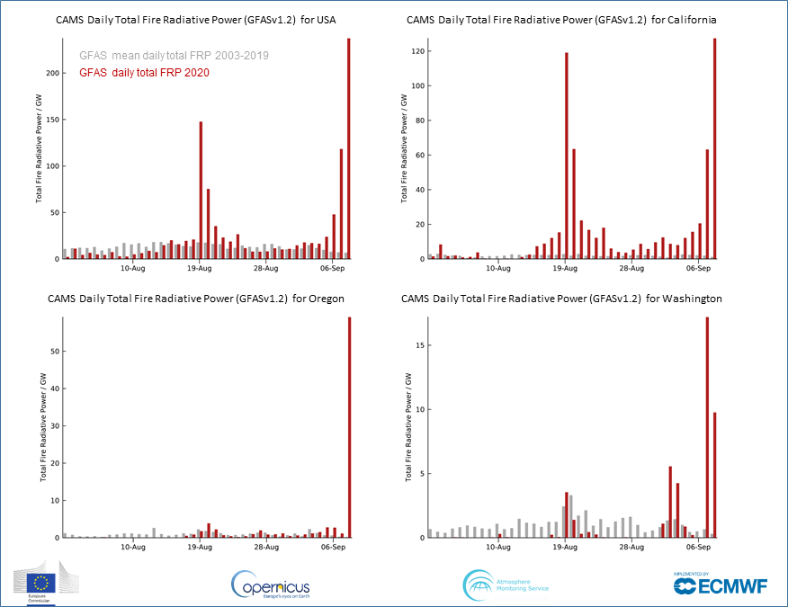
1 Aug - 8 Sept 2020 daily total #wildfire radiative power (cf 2003-2019 mean) for US, #CaliforniaFires, #OregonFires & #WashingtonFires from #CopernicusAtmosphere Monitoring Service GFAS data confluence.ecmwf.int/display/CKB/CA… based on NASA MODIS 🛰️ active fire observations #wildfireseason 
You could write an entire meteorology textbook just based on the phenomena visible from this afternoon's wild satellite imagery looking down at the American West. (Thread) #CAwx #WAwx #ORwx #COwx #UTwx #MTwx #IDwx
Most prominent is incredibly strong early-season cold front plunging southward from Canada and currently stretching along a roughly east-west axis from Eastern Washington to North Dakota. Clouds are rapidly developing behind the front as cold air replaces a very hot airmass.
Next, there are numerous large wildfire smoke plumes visible in nearly every state not covered by clouds--including Washington, Oregon, California, Utah, Idaho, and Colorado. The total smoke volume is massive, and extends across most of the continental U.S.
Breezy Frasier outflow is underway in Whatcom County, with much drier air and gusty winds beginning to filter into Lynden, Ferndale, and Bellingham. #wawx 

Meanwhile, breezy winds from the north are continuing to develop and spread across the Puget Sound region and will continue through the day.
Some gusts as of 11 AM:
Whidbey Island NAS: 30 mph
Bremerton: 32 mph
Sea-Tac: 25 mph
Olympia: 23 mph
Chehalis: 21 mph
#wawx
Some gusts as of 11 AM:
Whidbey Island NAS: 30 mph
Bremerton: 32 mph
Sea-Tac: 25 mph
Olympia: 23 mph
Chehalis: 21 mph
#wawx
Of course, we meant Fraser outflow. I guess this forecaster has 90s sitcoms on the brain. #wawx
This satellite image (brightened up nicely by the dept. of Atmospheric Sciences at the University of Washington) is from 721am this morning. It shows the areas of morning low clouds and fog--which will burn off pretty quickly today. 
...here's a wider shot of the West this morning showing the smoke from wildfires #wawx 

Interesting to compare the meteorological summers (and September) of 1989 and 2020 in Seattle. The summer average temperature and total precipitation numbers were similar followed by a long warm stretch in September. That, and I can still recite the lyrics to Dr. Feelgood. #wawx
Addendum to 1989 tweet. Though I can recite those lyrics - it's the Cure's Disintegration album that remains a favorite from that summer. OK, back to the weather. 😎
The winter of 1989-1990 was warmer than normal with a cold February. Two day snow event Feb. 16-17 gave Seattle 9.8" ( the only measurable snow in Seattle for the winter ). Rain was above normal because of a very wet January. It was a neutral year ( no La Nina or El Nino ). #wawx
