Discover and read the best of Twitter Threads about #Sentinel2
Most recents (24)
2/ US Navy's Supervisor of Salvage and Diving (SUPSALV) maintains the
Emergency Ship Salvage Material (ESSM) System, with prepositioned response kit around the world, including in Singapore.
@johnkonrad
navsea.navy.mil/Home/SUPSALV/E…
Emergency Ship Salvage Material (ESSM) System, with prepositioned response kit around the world, including in Singapore.
@johnkonrad
navsea.navy.mil/Home/SUPSALV/E…
3/ RTN seems prepared for the worst: Commander-in-Chief of the Royal Thai Navy ordered various units of the Navy to help.
First cloud-free #Sentinel2 satellite images in a month dropped yesterday. Great to check out snow levels, reservoirs, and wet wet wet in the Butte Basin/Lower Sacramento River. First image compares Colusa area now vs 12/15/2022. #Geography #RemoteSensing #CaWx #CaStorm 1/x 


Las Vegas 1972 - 2022 | #Landsat #Landsat50 🛰️
Extra 1 | Overview of Las Vegas, Lake Mead, Hoover Dam & Colorado River - #Landsat 🛰️ false color composite - July 2022 

Extra 2 | Las Vegas | Zooming-in on the NW zone.
Note that first images are a bit more blurry due to the lower spatial resolution of the first #Landsat satellites🛰️ More about it: usgs.gov/landsat-missio…
Note that first images are a bit more blurry due to the lower spatial resolution of the first #Landsat satellites🛰️ More about it: usgs.gov/landsat-missio…
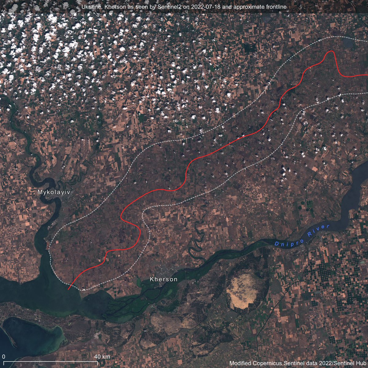
It's harvest season in Southern Ukraine🇺🇦 but agricultural activity has largely halted in areas most affected by the fighting.
The impact is so severe that it can be clearly seen from space🛰️ Can you spot it?
🧵 #OSINT #eochat
The impact is so severe that it can be clearly seen from space🛰️ Can you spot it?
🧵 #OSINT #eochat

Recently harvested fields are seen in light brown in this #Sentinel2 image from Kherson region;
a distinctly darker belt is seen around the line of contact, where harvesting has been impossible.
a distinctly darker belt is seen around the line of contact, where harvesting has been impossible.
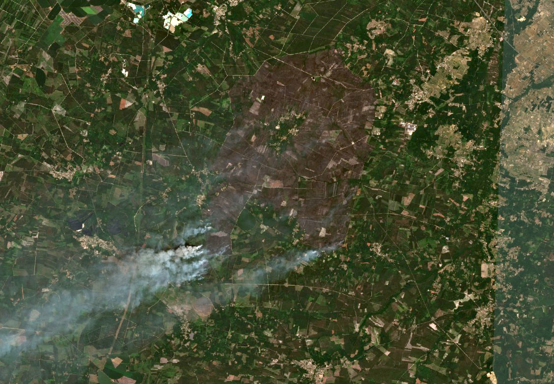
Hé les @decodeurs c'est super d'utiliser #Sentinel2 mais attention il n'y a pas d'image prise le 21 juillet... lemonde.fr/les-decodeurs/… 

L'image que vous avez utilisée date du 17 juillet alors que le feu n'avait pas atteint sa surface max. apps.sentinel-hub.com/sentinel-playg… 
It is visually confirmed that something is burning in #Kherson. It is currently rumored that #Ukraine Armed Forces lead an assault against the Airport. So I looked into it a little bit.
Taking a look at #Sentinel2 imagery, the latest flyover from the constellation was at 8:57 GMT. There is a concentration of what appear to be helicopters on the apron, along with pit marks from previous MLRS strikes. 

With fire evidently present, utilizing #FIRMS. The first indications of fire were detected at 10:51 GMT. With the fire of the greatest brightness correlating concentration of helis on the apron. 

🌋A wonderful illustration that will now need some updating
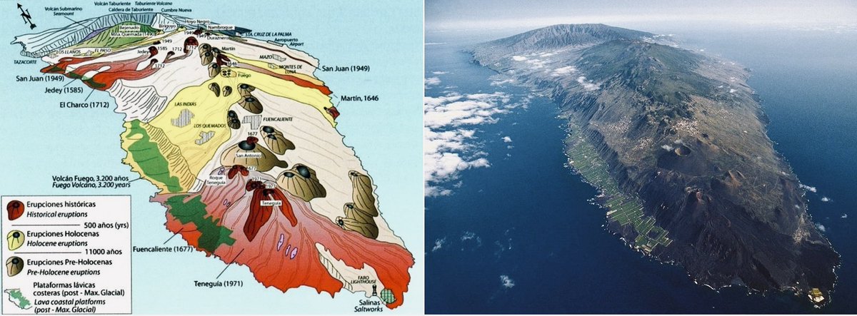
🌋Recent #volcanic eruptions on #LaPalma (until 19 September 2021)
🌋Photo: Sergio Socorro, image: J.C. Carracedo et al.
#CumbreVieja #LaPalmaEruption #lapalmavolcano #geohazards #LaPalmaIslaBonita
🌋Recent #volcanic eruptions on #LaPalma (until 19 September 2021)
🌋Photo: Sergio Socorro, image: J.C. Carracedo et al.
#CumbreVieja #LaPalmaEruption #lapalmavolcano #geohazards #LaPalmaIslaBonita
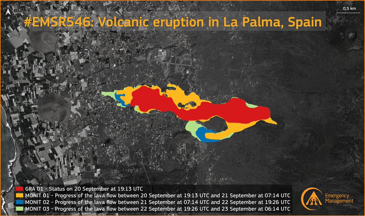
🌋 An updated lava flow map has just been published by the #RapidMappingTeam of @CopernicusEMS
#LaPalmaEruption #CumbreViejaVolcano #LaPalma

#LaPalmaEruption #CumbreViejaVolcano #LaPalma
🌌👨🚀 The #LaPalmaVolcano eruption as seen by @esa astronaut @Thom_astro from the International Space Station
#CumbreVieja #volcano #LaPalma #Canarias

#CumbreVieja #volcano #LaPalma #Canarias

Quand #Panama bloque #Suez : le porte-conteneurs #EVERGIVEN bloqué au sud du Canal de Suez, vu par le satellite #Sentinel2 le 24 mars. Première leçon : faire demi-tour dans un canal de 300m de large n'est pas l'idée du siècle quand on mesure 400m... #Copernicus #EarthObservation 

Mise en service en 2018, #EVERGIVEN est un gros navire, un des plus gros porte-conteneurs : 400 mètres de longueur et 220000 GT (drôle d'unité) de tonnage. Il appartient à la société taïwanaise Evergreen Marine et bat pavillon panaméen. Photo Kees Torn #Suez 

L'accident du porte-conteneurs #EVERGIVEN s'est produit le 23 mars au matin, bloquant la totalité du trafic du canal de #Suez. Les données #AIS montrent que ça se bouscule au portillon. Pour fixer les idées, une vue globale du canal de Suez. Image #Sentinel2 du 24/03 #Copernicus 


Massive new #QGIS plugin: #GEE Timeseries Explorer offers instant access to #EarthEngine image collections! Fetch #Landsat, #Sentinel2, or #MODIS #timeseries for any location and visualize images: geetimeseriesexplorer.readthedocs.io 🧵
Choose from our predefined collections, for instance merged & #cloud masked #Landsat TM, ETM+, OLI surface reflectance, cloud masked Sentinel2AB L2A, or just define your awesome custom collection in the built-in #Python editor. 

Extract time series profiles for #training / #validation by clicking on map, or by navigating through vector point file. Download raw time series data for #sample-based workflows efficiently with parallel download.
A friend of mine (@hazeldickens) recently asked @HayleyEversKing and I; “Can you see the #Jacaranda trees, which bloom every year in #Pretoria, from space?”…#thread (1/n)
For those that have never seen them; #Jacarandas grow all over #Pretoria & #Johannesburg & each year explode in an incredible purple display between September & November. We saw these when we visited @UPTuks in 2011, on an @Access_HP course & they are stunning! (2/n)
We’re not land remote sensing aficionados (ocean please!), but decided to have a look using @CopernicusEU @ESA_EO #Sentinel2 data. We started by comparing a time of year when we know the trees are in bloom (now), with one where we know that weren’t (July) (3/n)
#ImageOfTheDay
#Penguin colonies are located in areas affected by #ClimateChange
On 25 September @CopernicusEU #Sentinel2 🇪🇺🛰️ acquired its first image of the 2020 season of the Dawson-Lambton 🐧 colony in #Antarctica 🇦🇶
Check the reduction of the colony's size 2018-2020🐧⬇️
#Penguin colonies are located in areas affected by #ClimateChange
On 25 September @CopernicusEU #Sentinel2 🇪🇺🛰️ acquired its first image of the 2020 season of the Dawson-Lambton 🐧 colony in #Antarctica 🇦🇶
Check the reduction of the colony's size 2018-2020🐧⬇️

#FollowThePoo
After the death of thousands of penguins in 2016 due to the collapse of an ice sheet in 🇦🇶, survivor🐧 joined the Dawson-Lambton colony (DLc) increasing the population of the colony
In September 2020, as shown by #Sentinel2 🇪🇺🛰️, DLc population🐧has decreased
After the death of thousands of penguins in 2016 due to the collapse of an ice sheet in 🇦🇶, survivor🐧 joined the Dawson-Lambton colony (DLc) increasing the population of the colony
In September 2020, as shown by #Sentinel2 🇪🇺🛰️, DLc population🐧has decreased
#ImageOfTheDay
After the #heatwave♨️, snow☃️ is covering mountains in Europe
In 🇫🇷 🇪🇸 levels of snow that had not been seen since 2007 for September have been recorded
⬇️@CopernicusEU #Sentinel2 🇪🇺🛰️image of the #Pyrenees acquired yesterday
👉 Find 'Col du #Tourmalet' 🚴♂️
After the #heatwave♨️, snow☃️ is covering mountains in Europe
In 🇫🇷 🇪🇸 levels of snow that had not been seen since 2007 for September have been recorded
⬇️@CopernicusEU #Sentinel2 🇪🇺🛰️image of the #Pyrenees acquired yesterday
👉 Find 'Col du #Tourmalet' 🚴♂️

FYI @salguero_tv @MeteoAnd_OECC @MeteoGib
@windyforecast @CEAM_Meteo @Meteos_ @GaetanHeymes @KeraunosObs @VigiMeteoFrance
@ScottDuncanWX @TerliWetter @EKMeteo @severeweatherEU @Rub_dc @RAM_meteo @Tiempo_Mercedes @jantsalado @aeclim @Rafacereceda @ecazatormentas @AEMET_CValencia
@windyforecast @CEAM_Meteo @Meteos_ @GaetanHeymes @KeraunosObs @VigiMeteoFrance
@ScottDuncanWX @TerliWetter @EKMeteo @severeweatherEU @Rub_dc @RAM_meteo @Tiempo_Mercedes @jantsalado @aeclim @Rafacereceda @ecazatormentas @AEMET_CValencia
Another view
#ImageOfTheDay
#Villarrica is one of the most active volcanoes in #Chile
Yesterday ash emissions have been observed in situ
@CopernicusEU #Sentinel2 🇪🇺🛰️acquired this cloud-free view of the crater a few hours (14:53 UTC) before the start of this volcanic activity🌋
#Villarrica is one of the most active volcanoes in #Chile
Yesterday ash emissions have been observed in situ
@CopernicusEU #Sentinel2 🇪🇺🛰️acquired this cloud-free view of the crater a few hours (14:53 UTC) before the start of this volcanic activity🌋

source
#𝙄𝙢𝙖𝙜𝙚𝙊𝙛𝙏𝙝𝙚𝘿𝙖𝙮
One of the worst #ecodisaster in the #Arctic Circle happened in May in #Norilsk 🇷🇺
Studies have since found issues with other fuel tanks🛢️
This #Sentinel2🛰️🇪🇺 image shows that contaminated soil🖲️🚧stored around the Ambarnya river has been removed
One of the worst #ecodisaster in the #Arctic Circle happened in May in #Norilsk 🇷🇺
Studies have since found issues with other fuel tanks🛢️
This #Sentinel2🛰️🇪🇺 image shows that contaminated soil🖲️🚧stored around the Ambarnya river has been removed

Source:
#𝗜𝗺𝗮𝗴𝗲𝗢𝗳𝗧𝗵𝗲𝗗𝗮𝘆
2020 was the hottest summer on record in the Northern Hemisphere
The #Arctic #icecaps have melted 7⃣times more than in a “normal” summer, breaking all previous records
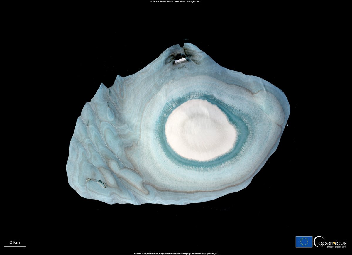
⬇️The ice cap of Schmidt Island 🇷🇺 as seen by @CopernicusEU #Sentinel2🇪🇺🛰️on 31/8
2020 was the hottest summer on record in the Northern Hemisphere
The #Arctic #icecaps have melted 7⃣times more than in a “normal” summer, breaking all previous records
⬇️The ice cap of Schmidt Island 🇷🇺 as seen by @CopernicusEU #Sentinel2🇪🇺🛰️on 31/8
#ImageOfTheDay
#Pantanal is on fire
As shown in this @CopernicusEU #Sentinel2 🇪🇺🛰️ image, the Encontro das Aguas Park, the area with the largest population of jaguars 🐆 in🇧🇷, is being reduced to ashes
The #biodiversity loss from the burning in these #wetlands is enormous
#Pantanal is on fire
As shown in this @CopernicusEU #Sentinel2 🇪🇺🛰️ image, the Encontro das Aguas Park, the area with the largest population of jaguars 🐆 in🇧🇷, is being reduced to ashes
The #biodiversity loss from the burning in these #wetlands is enormous

FYI @rrrocean @raullsantiago @luizacaires3 @claudia_gaigher @sergioajv1 @Diogotapuio @g1 @alice_pataxo
Source: apnews.com/949544b4f28905…
#EUSpace for global Emergency Management
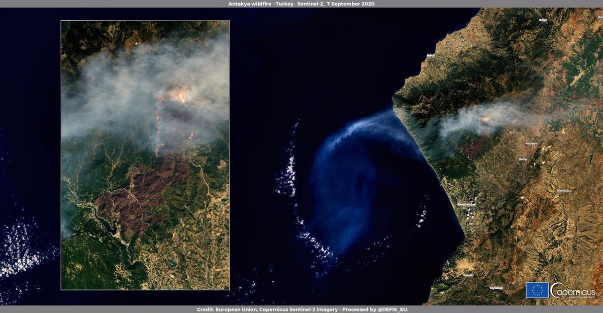
Since 5 September, a #wildfire is affecting the area near Antakya, in the province of #Hatay, #Turkey 🇹🇷
Here it is as seen by the @CopernicusEU #Sentinel2 🇪🇺🛰️ on 7 August
Since 5 September, a #wildfire is affecting the area near Antakya, in the province of #Hatay, #Turkey 🇹🇷
Here it is as seen by the @CopernicusEU #Sentinel2 🇪🇺🛰️ on 7 August
FYI
@OktayGokce1972
@ibbitfaiye
@fatiherturk62 @haskologlu
@TCTarim
@Hurriyet
@mert__firat
@AFADTurkey
@OktayGokce1972
@ibbitfaiye
@fatiherturk62 @haskologlu
@TCTarim
@Hurriyet
@mert__firat
@AFADTurkey
In situ images are impressive...
#ImageOfTheDay
The volume of glacial lakes worldwide has increased by ~50% in 30 years, as a result of #glaciers melting
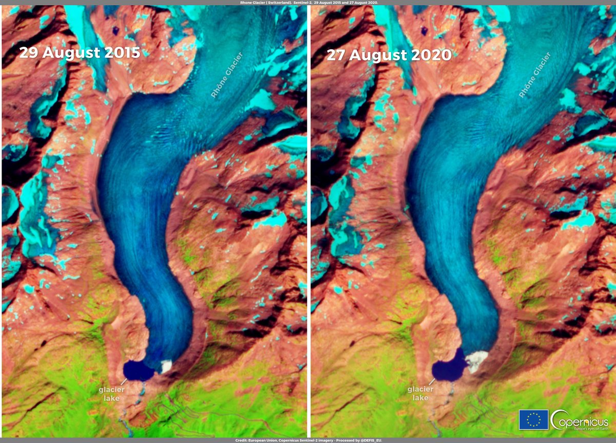
⬇️@CopernicusEU #Sentinel2 🇪🇺🛰️images of the Rhône Glacier glacial lake🇨🇭 in 2015 & 2020
Effects of #ClimateChange are evident
👉#ClimateAction is essential
The volume of glacial lakes worldwide has increased by ~50% in 30 years, as a result of #glaciers melting
⬇️@CopernicusEU #Sentinel2 🇪🇺🛰️images of the Rhône Glacier glacial lake🇨🇭 in 2015 & 2020
Effects of #ClimateChange are evident
👉#ClimateAction is essential
Source: nature.com/articles/s4155…
#EUSpace for global Emergency Management
California's #SQFComplex #wildifre has been burning since 19 August
So far it has consumed 15,000+ ha and remains 0% contained
Here it is as seen by the @CopernicusEU #Sentinel2 🇪🇺🛰️ on 5 August
#CaliforniaFires #CAwx
California's #SQFComplex #wildifre has been burning since 19 August
So far it has consumed 15,000+ ha and remains 0% contained
Here it is as seen by the @CopernicusEU #Sentinel2 🇪🇺🛰️ on 5 August
#CaliforniaFires #CAwx

FYI @ABC30 @KMPHFOX26 @ClimateReality @TRF_Climate @m_parrington @Weather_West @ECOWARRIORSS @ai6yrham @wildfiretoday
@caudronmartin @CityofFresno @CEDRdigital @NWSHanford @ai6yrham @sequoiaforest @forestservice
@caudronmartin @CityofFresno @CEDRdigital @NWSHanford @ai6yrham @sequoiaforest @forestservice
Source
#ImageOfTheDay - Thread 1/2
#HurricaneLaura sowed death & destruction on the Louisiana coast 🇺🇸
It is difficult to quantify damages, but the images of @CopernicusEU #Sentinel2 🇪🇺🛰️give an idea of the devastation around Cameron Parish
Check the before/after comparison below⬇️
#HurricaneLaura sowed death & destruction on the Louisiana coast 🇺🇸
It is difficult to quantify damages, but the images of @CopernicusEU #Sentinel2 🇪🇺🛰️give an idea of the devastation around Cameron Parish
Check the before/after comparison below⬇️

#HurricaneLaura2020 sowed death & destruction on the Louisiana coast 🇺🇸
The images of @CopernicusEU #Sentinel2 🇪🇺🛰️help to quantify damages around Creole, Cameron Parish
This is a comparison between 16 / 31 August 2020
Slider➡️edefis.eu/HurricaneLaura…
The images of @CopernicusEU #Sentinel2 🇪🇺🛰️help to quantify damages around Creole, Cameron Parish
This is a comparison between 16 / 31 August 2020
Slider➡️edefis.eu/HurricaneLaura…
#ImageOfTheDay - Thread 2/2
#Hurricane #Laura sowed death & destruction on the Louisiana coast 🇺🇸
The damages are widespread and the images of @CopernicusEU #Sentinel2 🇪🇺🛰️give an idea of the devastation around Cameron Parish
Check the before/after comparison below⬇️
#Hurricane #Laura sowed death & destruction on the Louisiana coast 🇺🇸
The damages are widespread and the images of @CopernicusEU #Sentinel2 🇪🇺🛰️give an idea of the devastation around Cameron Parish
Check the before/after comparison below⬇️

#EUSpace for #CulturalHeritage
4 water bombers and two helicopters helped dozens of firefighters contain a huge blaze on Sunday at the edge of one of Greece's most important archaeological sites: Mycenae #Μυκήνες
Here is the burn scar as seen by the @CopernicusEU
#Sentinel2🇪🇺🛰️
4 water bombers and two helicopters helped dozens of firefighters contain a huge blaze on Sunday at the edge of one of Greece's most important archaeological sites: Mycenae #Μυκήνες
Here is the burn scar as seen by the @CopernicusEU
#Sentinel2🇪🇺🛰️

FYI @amna_news
@aboubouka
@PlanetekHellas
@evy_papantoniou
@IoannisM8
@ipapouts
@iphigenia_k
@ekathimerini
@margochrysakis
@NatassaAntoniou
@nefeluke
@RegioGreece
@stellinaenv
@aboubouka
@PlanetekHellas
@evy_papantoniou
@IoannisM8
@ipapouts
@iphigenia_k
@ekathimerini
@margochrysakis
@NatassaAntoniou
@nefeluke
@RegioGreece
@stellinaenv
Media Report: greekcitytimes.com/2020/08/31/fir…
#ImageOfTheDay
Floods have caused 90 casualties while 380,000+ have been affected following heavy rains in #Sudan🇸🇩 since the start of the 2020 rainy season🌧️
This image acquired by @CopernicusEU #Sentinel2 🇪🇺🛰️ on 30 August shows the flooded zones near Khartoum
#فيضان_السودان
Floods have caused 90 casualties while 380,000+ have been affected following heavy rains in #Sudan🇸🇩 since the start of the 2020 rainy season🌧️
This image acquired by @CopernicusEU #Sentinel2 🇪🇺🛰️ on 30 August shows the flooded zones near Khartoum
#فيضان_السودان

#ImageOfTheDay #EUSpace for Emergency Management (1)
A severe #wildfire broke out in Almonaster La Real, #Spain and numerous water bombers & firefighters are battling to contain the blaze
@CopernicusEMS is activated
#Sentinel2 🇪🇺🛰️ image of #IFAlmonasterLaReal acquired yesterday
A severe #wildfire broke out in Almonaster La Real, #Spain and numerous water bombers & firefighters are battling to contain the blaze
@CopernicusEMS is activated
#Sentinel2 🇪🇺🛰️ image of #IFAlmonasterLaReal acquired yesterday

FYI @InteriorJunta @UMEgob @AT_Brif @Josefislop @eforestal @vostSPAIN @VOSTandalucia @IncendiosES @HuelvaJunta @ANEPPCE @J_Ramos_CIEM @El_Batefuegos @WildlandFirefig @Rafacereceda @Isabelbombal1 @rodrigo0silva @_JuanCsanchez_ @meganrowling @tiempobrasero @ricardo_dgb @ESA_EO
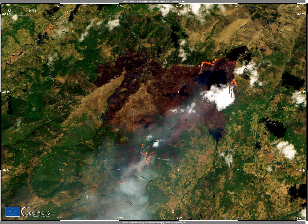
@CopernicusEMS #RapidMappingTeam estimates the area affected by #IFCabezuelaDelValle at 8,593.5 ha
An updated map should be produced today if cloud-free satellite imagery can be acquired
emergency.copernicus.eu/EMSR457
An updated map should be produced today if cloud-free satellite imagery can be acquired
emergency.copernicus.eu/EMSR457

#ImageOfTheDay #EUSpace for Emergency Management (2)
A severe #wildfire broke out Cabezuela Del Valle #Spain🇪🇸, a #Natura2000 site
@CopernicusEMS is activated and estimates the affected area at 2,566.5 ha
#Sentinel2 🇪🇺🛰️ imagery of #IFCabezuelaDelValle acquired yesterday
A severe #wildfire broke out Cabezuela Del Valle #Spain🇪🇸, a #Natura2000 site
@CopernicusEMS is activated and estimates the affected area at 2,566.5 ha
#Sentinel2 🇪🇺🛰️ imagery of #IFCabezuelaDelValle acquired yesterday
