Discover and read the best of Twitter Threads about #AtmosphericRiver
Most recents (17)
Okay, folks. Starting to look like it's going to be a rough 10+ days from a flood risk perspective in Northern California, with a series of very wet & high-impact storms. Brief thread now; blog post late this PM; YouTube live Q&A Tue. [1/n] #CAwx #CAwater
The next inbound storm looks like it will be quite strong. A rapidly deepening surface low (i.e., meteorological "bomb cyclone") will remain well offshore, but the associated warm and cold fronts will bring widespread heavy rain and strong winds to NorCal later Wed. #CAwx [2/n] 

This storm would be fairly notable in its own right, as it will be associated with an unusually well-defined warm *and* cold frontal passages and an exceptionally moist and relatively warm #AtmosphericRiver. #CAwater #CAwx [3/n] 

2023 is bringing us an #AtmosphericRiver for its arrival! Because 280 characters is never enough to summarize these, here's another 🧵of our updates and what we're expecting! #CAwx (1/6)
We've hoisted a Flood Watch for tomorrow evening given the potential for widespread rainfall everywhere from the mountains westward. Use extra caution if you're out and about! Travel will be dangerous given rain, lots of folks on the road, and... other reasons🥴#IYKYK #CAwx (2/6) 


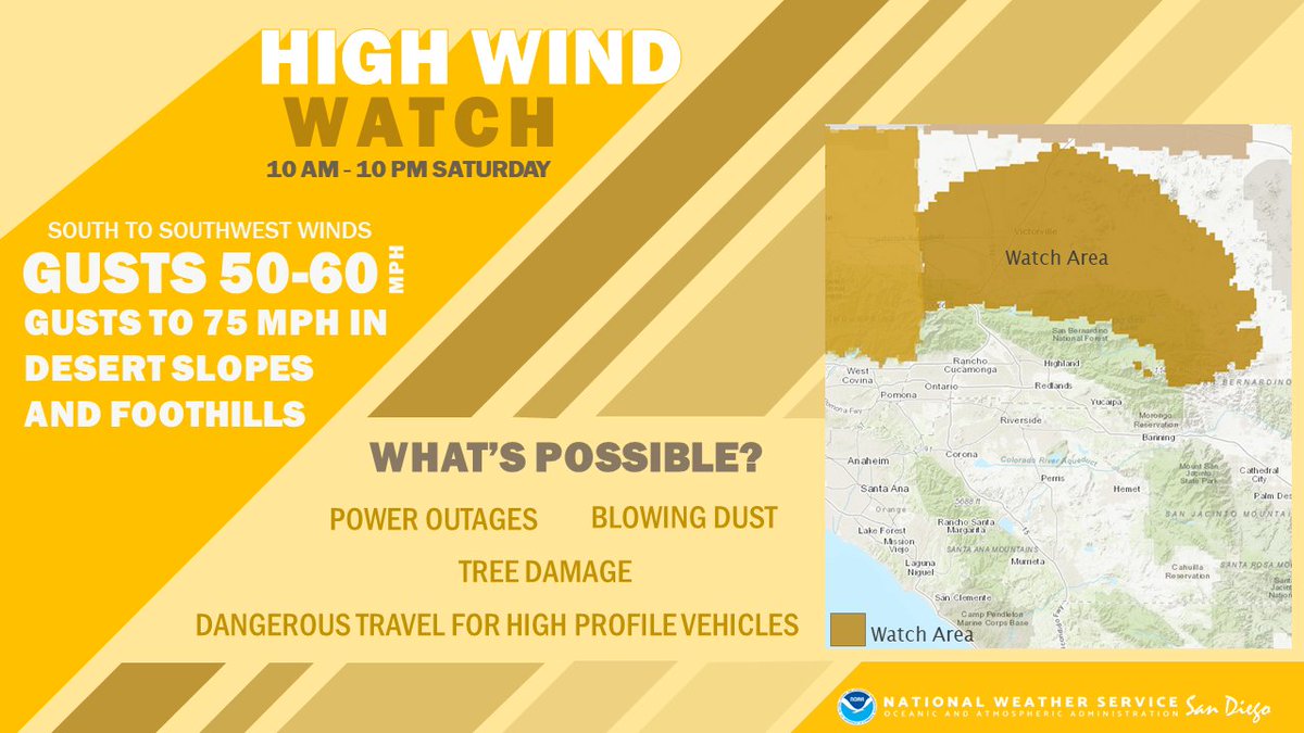
It'll also be windy during the daytime on Saturday, the kinda wind that likes to transport trash cans, unsecured holiday decor, and other loose objects. Use caution if traveling in a high-profile vehicle as well. #CAwx (3/6) 


#HurricaneKay weakening into a tropical storm will bring widespread showers with potential for inland flooding to the Southern California region, says @jaycordeira of @CW3E_Scripps. View the water vapor transport forecast showing the storm’s movement: cw3e.ucsd.edu/ivt_iwv_uswc/
“The storm's circulation will drag water vapor up the Mexican coastline & into SoCal, but will be drastically different than the hurricane making landfall here. The latest forecasts bring the storm's circulation (tropical storm) to SD.” - @jaycordeira of @CW3E_Scripps
It's been a while since a large tropical storm has come close to SoCal & #HurricaneKay is showing up in @CW3E_Scripps’ #AtmosphericRiver (AR) forecast tools. ARs move water vapor in long narrow corridors, producing rain when making landfall. More on ARs⬇️
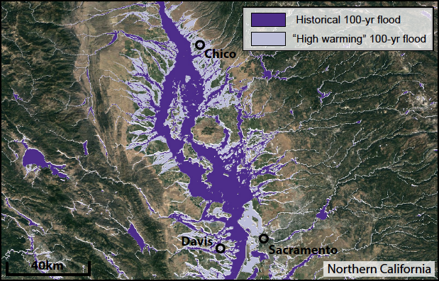
New work co-led by @xingyhuang and me on the rising risk of a California #megaflood due to #ClimateChange is out today in @ScienceAdvances! This paper also describes the new #ARkStorm2 scenarios in detail, & will be the basis for ongoing work. (Thread:1/n) science.org/doi/10.1126/sc…
For context: the work and findings presented here represent the first phase of the broader #ARkStorm2 project, a multi-year, cross-institutional effort involving multiple @UofCalifornia campuses, @DRIScience, @USGS, @CA_DWR, & @NCAR_Science. (2/n) science.org/doi/10.1126/sc…
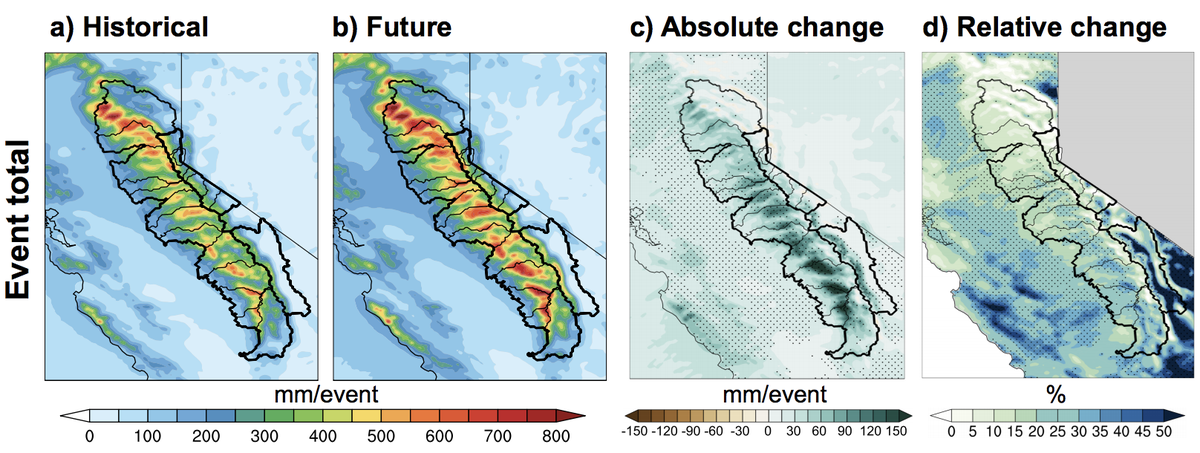
In this work, we develop a pair of plausible extreme, month-long winter storm sequences in California--one from the recent historical climate, and one from a much warmer future climate. These sequences involve a multi-week series of successive #AtmosphericRiver storms. (3/n) 

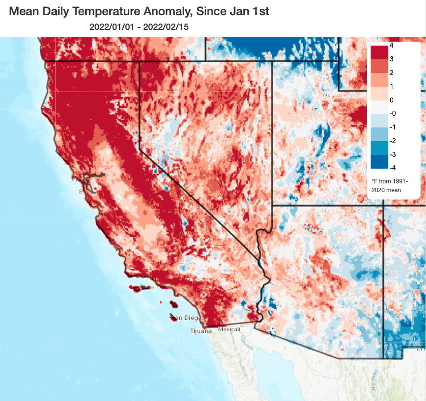
October and December were extremely wet in parts of California (record wet in some parts of NorCal). But the most recent ~45 day stretch (Jan 1-Feb 17) has been among driest mid-winter periods on record most of CA, NV, UT, and portions of adjacent states. #CAwx #CAwater (1/3) 

This has yielded in a seasonal "percent of average" precipitation map that is pretty misleading. Most of CA has slipped slightly below avg precip for the season to date--except for narrow swath along I-80 corridor that experienced the extreme Oct #AtmosphericRiver. #CAwx (2/3) 

On Nov 15, 2021 an #AtmosphericRiver hit the #Fraser Valley and Canyon. In support of a BC Salmon Restoration Innovation Fund #BCSRIF project and with support from @HakaiInstitute, we flew the Fraser Canyon to document the #floods and #landslides that occurred. 1/18 #BCStorm 

Our research examines how the size and frequency of landslides in Fraser Canyon affect river morphology, flow dynamics, #salmon migration, and their genetics. What follows are names, pictures, and coordinates of #landslide events we identified, both big and small. 2/18 #BCStorm
For the last three days significant tropical warm rains have been falling here in Glasgow in the lead up to #cop26.
Last night there were 164 floods reported around the city. #atmosphericriver
Last night there were 164 floods reported around the city. #atmosphericriver
Thread on very strong inbound CA storm. A cold & clear morning will quickly give way to increasing clouds, NorCal valley rain & snow down to 1,500-2,000 ft (locally lower) later this PM. Current satellite imagery shows this strengthening system off the coast. (1/10) #CAwx
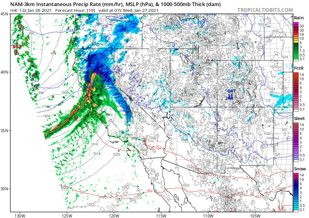
Tonight, a rapidly intensifying cold front will sweep across NorCal. This front will be unusually well defined, for a CA winter storm, and will replace an already cold airmass with...another cold airmass! (2/10) #CAwx 
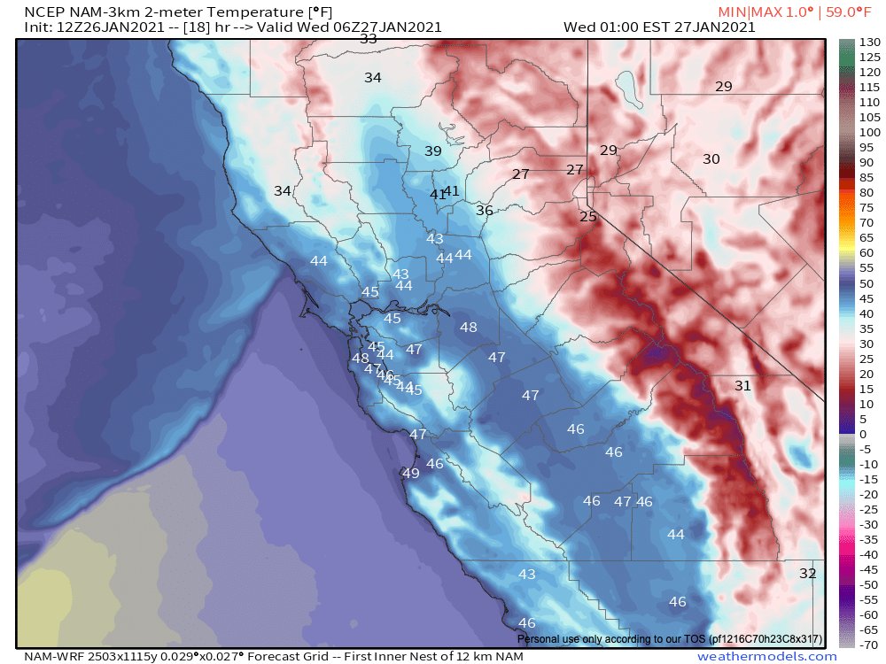
The cold frontal passage is expected to be quite dramatic across NorCal in the overnight hours. A convective "narrow cold frontal rainband" (NCFR) will likely develop, which could bring a period of torrential rain or snow to many areas, as well as possible lightning. (3/10) #CAwx 
In case you missed it: a "thread of threads" highlighting some of our collaborative research from 2020. How are wildfires, atmospheric rivers, floods, and other extreme events changing in a warming #climate (and in California specifically)? Read on for details: (1/8) #CAwater 

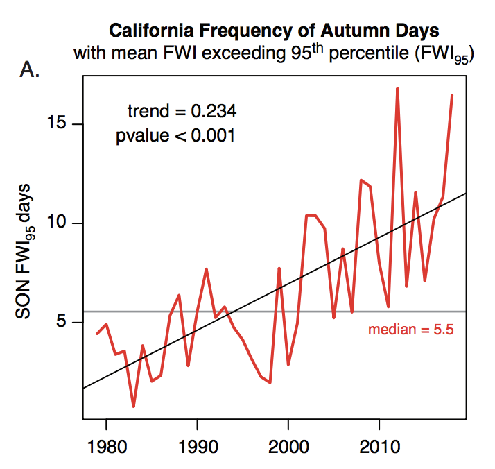
A general-audience primer on the rapidly advancing science of "extreme event attribution." How do scientists approach question of whether #ClimateChange is affecting likelihood and/or severity of extreme weather events? (2/8) @ClimateChirper @danielletouma
Our deep dive into extreme #AtmosphericRiver storms in California and how they are likely to warm & intensify considerably due to #ClimateChange. (3/8) @xingyhuang @ProfAlexHall
New work led by Xingying Huang on extreme #AtmosphericRiver storms in California in a warming climate is out today in @ScienceAdvances (open access)! A thread discussing our findings and their implications follows. #CAwx #CAwater #CAclimate (1/n) advances.sciencemag.org/content/6/29/e…
Top-level findings: we find that the most intense atmospheric river storms in California will be become considerably more intense as the climate warms, bringing substantially more precipitation overall as well as higher precipitation intensities. (2/n)
advances.sciencemag.org/content/6/29/e…
advances.sciencemag.org/content/6/29/e…

Weather/climate programming note: (1/3)
Our extreme #climate event attribution piece will be out this Friday in @OneEarth_CP (expect a Tweetstorm, and brief discussion in an upcoming Weather West blog post!). #CAwx #CAwater
Our extreme #climate event attribution piece will be out this Friday in @OneEarth_CP (expect a Tweetstorm, and brief discussion in an upcoming Weather West blog post!). #CAwx #CAwater
Then, in early July, our extreme California #AtmosphericRiver & #ClimateChange paper will be out in @ScienceAdvances (expect a dedicated Weather West blog post). #CAwx #CAwater (2/3)
In Aug/Sep, I'll have dedicated post discussing our recently published paper on #ClimateChange-caused increases in extreme CA wildfire conditions (& possibly also additional work, still in review, examining population exposure to public safety power shut-offs). #CAwx #CAfire(3/3)
A low pressure system off coast will move inland on Tuesday, bringing a widespread rain event to SoCal. This will be a warm/moist system with only modest dynamics, so almost everyone from Central Coast southward will see moderate rainfall of 0.5-2 inches. #CAwx 


However, this system does have plenty of moisture (associated w/an #AtmosphericRiver focused to the south and east of CA) and some respectable atmospheric instability. As a result, there's actually a decent chance of thunderstorms w/brief heavy downpours on Tues in SoCal. #CAwx 

NorCal, unfortunately, will only see scattered showers from this system. A slightly more promising chance of colder showers (& maybe some Sierra Nevada snow) comes about a week from now--but in general, ensembles continue to suggest below-average precipitation in long range.#CAwx 


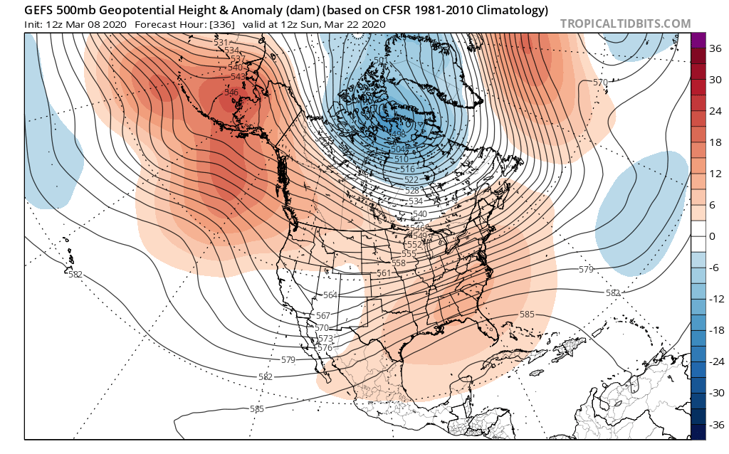
New work led by @SciGibson @NASAJPL! We take a deep dive into northeastern Pacific high pressure ridging, including trends, implications for California drought, #AtmosphericRiver activity, and possible underlying physical mechanisms. (1/6) #CAwx #CAwater journals.ametsoc.org/doi/full/10.11… 
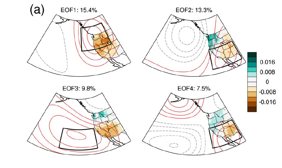
Light coastal rain showers (and mountain snow showers) are still expected to end prolonged dry spell in NorCal this weekend (finally!), although significant precip not expected. Then, early next week... 1/3 #CAwx #CAwater 

Early next week, a stronger & dramatically warmer system is expected to affect SoCal. Widespread, locally heavy rainfall is likely from this warm/wet #AtmosphericRiver--but only in far SoCal. Very high snow levels due to subtropical airmass. 2/3 #CAwx #CAwater 

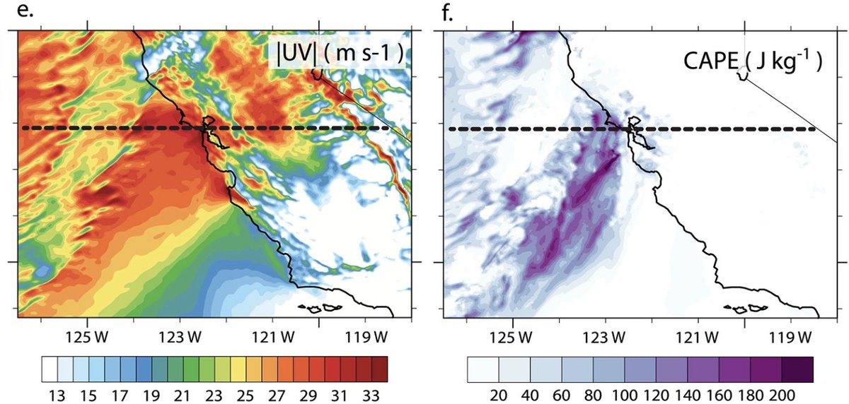
New research led by Xingying Huang on simulating extreme U.S. Pacific Coast #AtmosphericRiver storms. We found that our high resolution weather model configuration yielded substantial improvements in extreme precip representation. (1/3) agupubs.onlinelibrary.wiley.com/doi/full/10.10… #CAwx #CAwater 

We selected extreme AR events between 1980-2017, evaluating model performance specifically for the *most* intense precipitation in *wettest* regions. This modeling framework forms basis for forthcoming work on #AtmosphericRivers in warming climate. (2/3) #CAwater #CAwx 

One selected storm was Dec. 12 1995 event in N. California, which brought a violent windstorm to portions of SF Bay Area (100+ mph gusts!). This was actually a formative weather event of my childhood--it's one of the reasons why I'm an atmospheric scientist today! (3/3) #CAwx 
New work by Frances Davenport reveals "exponential response of streamflow to rain/snow fraction over western U.S. ... [implying] large potential for continued warming to increase flood risk, even without changes in precip frequency, magnitude, or timing." agupubs.onlinelibrary.wiley.com/doi/full/10.10… 


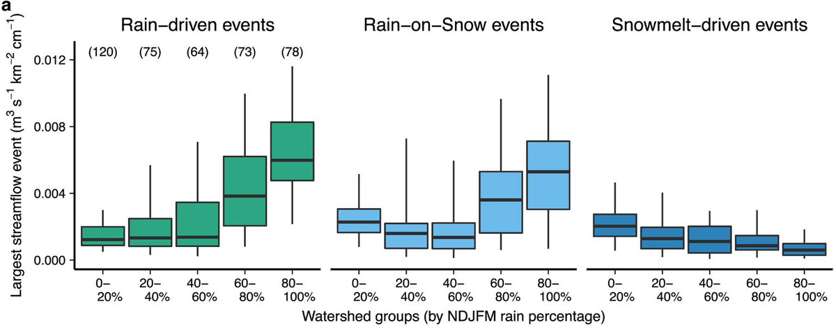
@StanfordEarth @MarshallBBurke @k_r_gonz @Stanford Considering that #AtmosphericRiver storms are already warming along the West Coast, this is a pretty big deal.
@StanfordEarth @MarshallBBurke @k_r_gonz @Stanford Also: the apparently quite large effect of increased rain vs. snow partitioning is emerging *in addition* to changes in the intensity, frequency, & seasonality of precipitation as the climate warms--likely further amplifying future increases in flood risk.
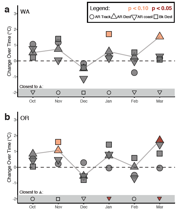
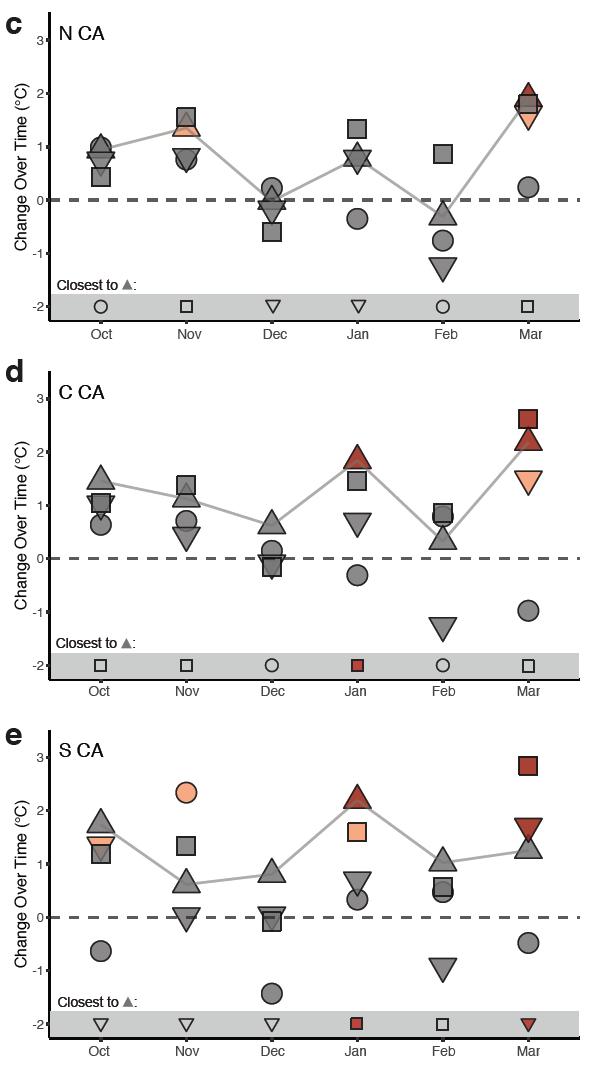
New research led by @k_r_gonz points to striking #AtmosphericRiver warming trend along U.S. West Coast in recent decades. We found that ARs have already warmed by > 2°C (3.6°F) in some months--faster than previous #climate projections had suggested. (1/8) agupubs.onlinelibrary.wiley.com/doi/10.1029/20… 
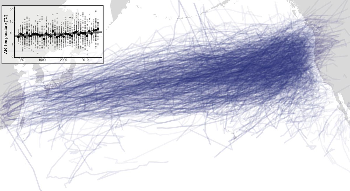
#AtmosphericRiver warming signal is robust in all regions during at least some months, including coastal Washington, Oregon, & California. But warming has been greatest in central & southern CA, especially during January & March. #CAwx #ORwx #WAwx (2/8) agupubs.onlinelibrary.wiley.com/doi/10.1029/20… 

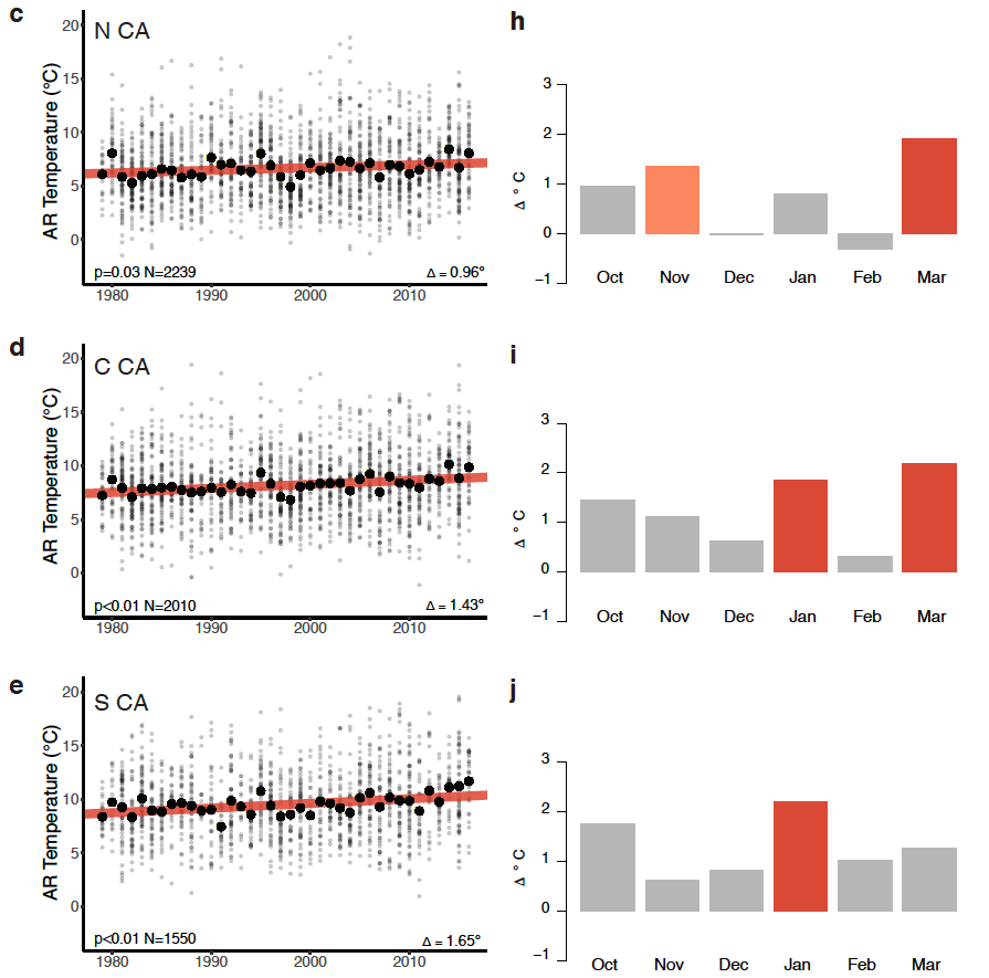
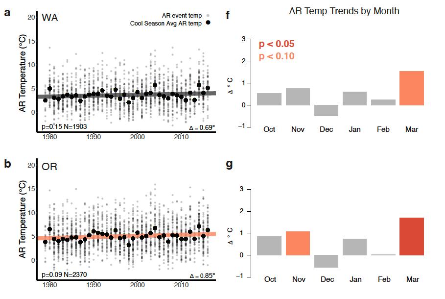
This #AtmosphericRiver warming appears to be driven by both local and geographically remote warming, but appears to scale most closely with near-shore ocean and local background (non-AR) temperature trends. (3/8) agupubs.onlinelibrary.wiley.com/doi/10.1029/20… 

