Discover and read the best of Twitter Threads about #utwx
Most recents (7)
Another day of monsoon season, and we're looking at a broader area of increased Flash Flood risk as moisture and dynamic support expand somewhat north and east today. The Flood Watch for flash flooding has been updated accordingly. Read on for a little more info... #utwx (1/4) 

Here's one model's representation of how convective activity could play out throughout the day and evening. Given the cloud cover and convective inhibition in place, the delayed start of more significant convection (likely not until 1-2PM) appears appropriate. (2/4)
1/9 To shed some light on the science, here's a schematic look at the structure of a downslope wind event along the Wasatch Front. For more detail on this graphic and the setup for this impactful event, keep reading... #utwx 

2/9 The September 2020 wind storm was a complex meteorological event combining elements of strong synoptic winds associated with deep low pressure system with components of a classic downslope wind event. It was this combination that led to a widespread, long-duration event #utwx
3/9 A pool of cold continental air moved southward from Canada through the Intermountain West with the progression of an upper-level trough. As the system deepened, upper level winds (our 'background' flow) increased, and significant transport of this dense cold air occurred.
1/7 It is the first anniversary of the 2020 Downslope Wind Storm that impacted much of northern Utah. This event goes down as one of the most widespread, impactful weather events the state has experienced in many years. This thread details some of the impacts. #utwx 

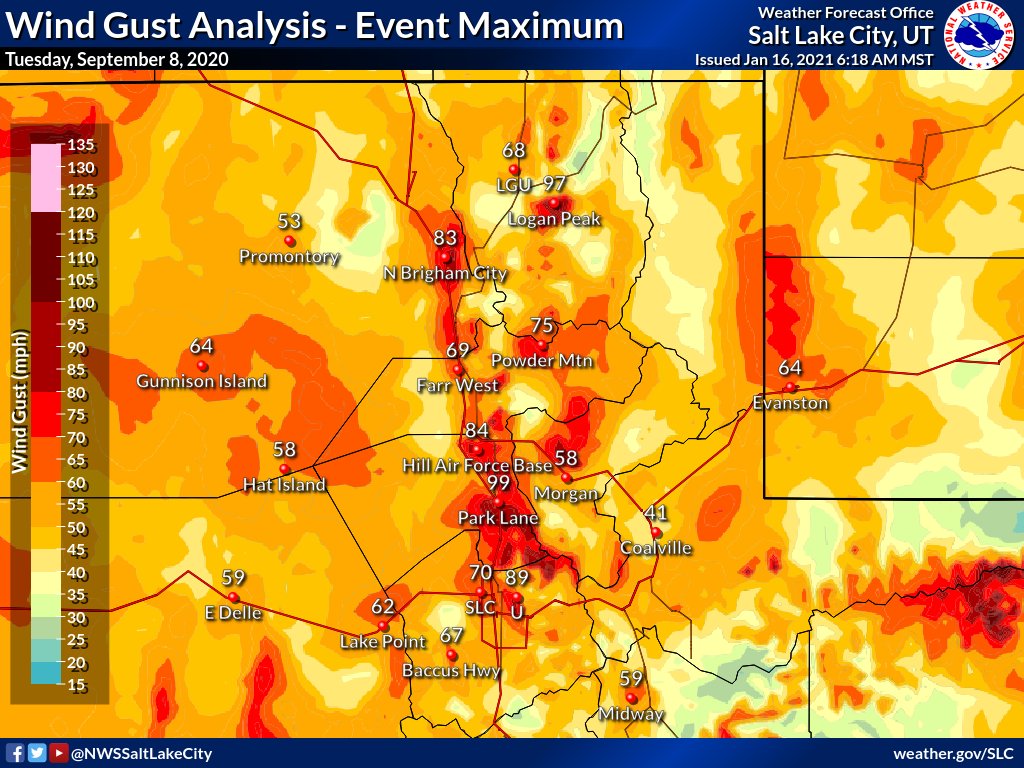
2/7 Here are the peak wind gusts for the event across northern Utah. Wind gusts as high as 99 mph were reported (with unofficial reports near the U over 100 mph). 

3/7 Initial reports estimated more than 4500 trees were damaged or downed during the event across mainly Salt Lake, Davis and Weber Counties. Liberty Park lost near 70 trees. Some of these tress were up to 100 years old. Tree damage was especially severe due full leaf canopies.
1/8 For those wondering why the mountains are no escape from the smoke these days... One key difference between our wintertime valley pollution and summertime smoke is the presence or lack of a stable layer in the form of a temperature inversion. #utwx 

2/8 This oversimplified graphic shows how the stable layer/temperature inversion creates a cap that traps a shallow layer of pollution near the surface in winter, while under warm and well mixed summer conditions, these pollutants (like smoke) are distributed throughout.
3/8 There are scenarios where the concentrations are high near the surface, and others where the surface remains relatively 'clean' while concentrations aloft are very high. But with enough smoke, over sufficient time and distance, distribution in the column becomes homogeneous.
Escalation of devastating #wildfires, smoke & surface #airpollution across entire western US with very high levels of surface PM2.5 for the coming days. @CopernicusECMWF Atmosphere Monitoring Service @ECMWF forecast initialized 9 Sept at 00 UTC visualized by @windyforecast
Link to forecast ➡️ windy.com/-PM2-5-pm2p5?c… #CAwx #CaliforniaFires #ORwx #OregonFires #WAwx #WashingtonFires #COwx #ColoradoFires #UTwx #UtahFires
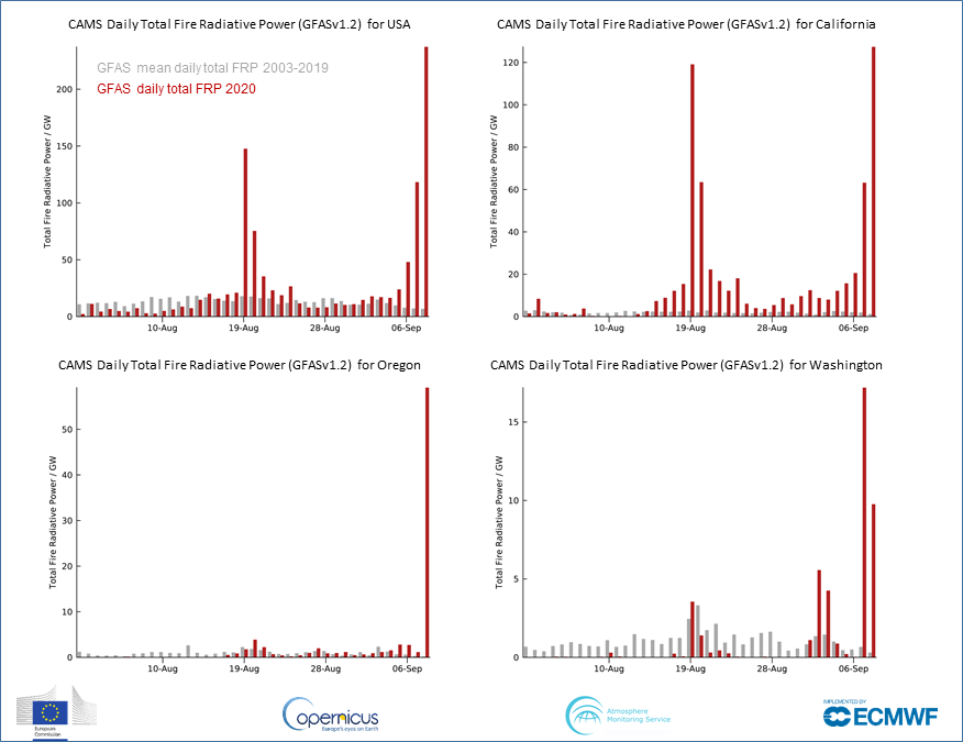
1 Aug - 8 Sept 2020 daily total #wildfire radiative power (cf 2003-2019 mean) for US, #CaliforniaFires, #OregonFires & #WashingtonFires from #CopernicusAtmosphere Monitoring Service GFAS data confluence.ecmwf.int/display/CKB/CA… based on NASA MODIS 🛰️ active fire observations #wildfireseason 

You could write an entire meteorology textbook just based on the phenomena visible from this afternoon's wild satellite imagery looking down at the American West. (Thread) #CAwx #WAwx #ORwx #COwx #UTwx #MTwx #IDwx
Most prominent is incredibly strong early-season cold front plunging southward from Canada and currently stretching along a roughly east-west axis from Eastern Washington to North Dakota. Clouds are rapidly developing behind the front as cold air replaces a very hot airmass.
Next, there are numerous large wildfire smoke plumes visible in nearly every state not covered by clouds--including Washington, Oregon, California, Utah, Idaho, and Colorado. The total smoke volume is massive, and extends across most of the continental U.S.
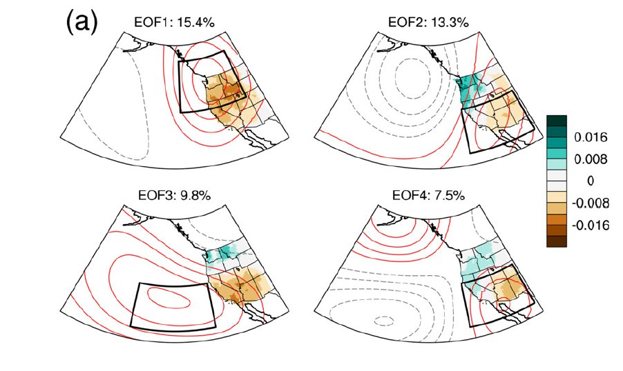
New work led by @SciGibson @NASAJPL! We take a deep dive into northeastern Pacific high pressure ridging, including trends, implications for California drought, #AtmosphericRiver activity, and possible underlying physical mechanisms. (1/6) #CAwx #CAwater journals.ametsoc.org/doi/full/10.11… 


