Discover and read the best of Twitter Threads about #Elsa
Most recents (22)
Did anyone just post a post - linking
#cookies and 🍪
#science? 👩🔬🧑🔬👨🔬
What a head start for a thread on the #psychology of the cookie monster and why utilitarianism is
2 things
at the same time! 🤯
#cookies and 🍪
#science? 👩🔬🧑🔬👨🔬
What a head start for a thread on the #psychology of the cookie monster and why utilitarianism is
2 things
at the same time! 🤯
awww - how I would LOVE to write about the 2 faces of #utilitarianism in the light of our digital future and how the #CookieMonster embodies
1) the worst dystopia and
2) the best utopia same time.
Problem is:
I am trapped in the space-time continuum. Just like ...
1) the worst dystopia and
2) the best utopia same time.
Problem is:
I am trapped in the space-time continuum. Just like ...
The cookie monster.
And my twitter life has too many cookies on the tray.
And there are just 44 minutes left before I will start my shopping trip with K1.
Oh - 43.
And my twitter life has too many cookies on the tray.
And there are just 44 minutes left before I will start my shopping trip with K1.
Oh - 43.
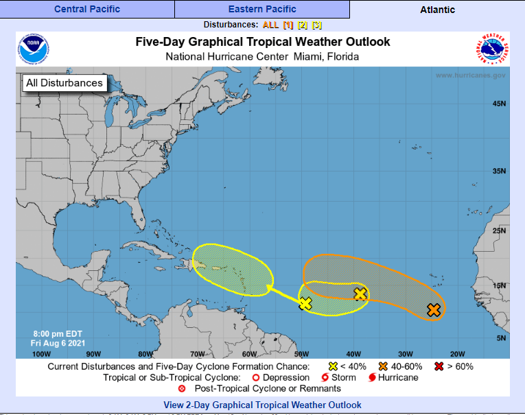
(1) We've had about a month since Hurricane #Elsa with quiet seas out in the Atlantic. That is about to change, as we approach peak season in late August/early Sept.
Some systems forming: nhc.noaa.gov/gtwo.php?basin…
Plus some E. Pacific storms.
#HWStormWatch🌀
Some systems forming: nhc.noaa.gov/gtwo.php?basin…
Plus some E. Pacific storms.
#HWStormWatch🌀
(2) Now is not the time for states like FL to be tormented by partisan political division & the rejection of life-saving steps like #GetVaccinated & #MaskUp.
It's never the time, but especially not in peak hurricane season.
#NoPoliticsOnTheBoat #ThisIsAmerica #RightMatters
It's never the time, but especially not in peak hurricane season.
#NoPoliticsOnTheBoat #ThisIsAmerica #RightMatters

(3) That Facebook post was written by a woman in Houston, TX affected by one of the worst US hurricanes on record, #Harvey in 2017.
How I wish the level of partisan division in 2021 was lower, like it was 4 years ago.
How I wish the level of partisan division in 2021 was lower, like it was 4 years ago.
A brief pictorial thread of parts of the northern hemisphere where extreme or unusual weather phenomena are underway.
Starting with #eastasia #infa & #3rdStorm which seems to have initiated formation. This is the storm which will crash #Olympics2021, shortly after the opening.
Starting with #eastasia #infa & #3rdStorm which seems to have initiated formation. This is the storm which will crash #Olympics2021, shortly after the opening.
The 1st animation is 120 hours. This version goes for 11 days longer. As on #infa’s path beyond 120 hours, what happens beyond July 26th is pretty uncertain. #infa is also continuously not behaving as expected, totes normal for a heat engine of this magnitude.
Heading west a few thousand miles the lingering impact of the #ArabianMomsoonBurst is set to continue for some time bringing thunderstorms to the Arabian peninsula on a daily basis. See @Arab_Storms for video reports.
The full monsoon has now arrived in the #HornOfAfrica. Very intense rain has begun in the Nile Basin and will continue for a week or more.
What will happen in the #MiddleEast is less clear, but it will involve a lot of rain and #ArabianStorms. Today's forecasts follow.
What will happen in the #MiddleEast is less clear, but it will involve a lot of rain and #ArabianStorms. Today's forecasts follow.
This animation shows the flow of rain bearing clouds heading south west across Pakistan which signals the first phase of an event which will intensify significantly over coming days.
This animation shows under wrapped in pulsating bands of storms headed both East and West. It is this intense period of Monsoon activity which is powering the phenomena that his bringing this rain to Yemen, Oman and Saudi Arabia.
The next two weeks promise to bring astonishing weather to both sides of the Red Sea & across the Sahara. In this weather bulletin I will explain what the models are forecasting.
Today's #NorthAfrica #HornOfAfrica and #MiddleEast rainfall forecasts follow.
Today's #NorthAfrica #HornOfAfrica and #MiddleEast rainfall forecasts follow.

In the image above we see part of Arabia and part of the #NileBasin storms - those which feed the Blue Nile/Abbay and the Tekeze basins the source of most of the Nile's flow.
Below we see:
1. All Nile Basin rainfall as of this evening
2. All of this evenings #ArabianStorms

Below we see:
1. All Nile Basin rainfall as of this evening
2. All of this evenings #ArabianStorms


Is it time for your yearly refresher on Richmond's Combined Sewer System?
If it is, maybe it's also time to make sure you get our email alerts when an overflow event occurs.
Insider tip: use all lowercase characters in your email address!
apps.richmondgov.com/applications/C…
Insider tip: use all lowercase characters in your email address!
apps.richmondgov.com/applications/C…
If you haven’t read through our whole combined sewer system (or CSS) thread 🧵 (you really should—we can’t top it!) or checked out our CSS webpage yet (at rvah2o.org/combined-sewer…), or our StoryMap (at cor.maps.arcgis.com/apps/Cascade/i…), our most basic TL;DR version is coming up for you. 3/
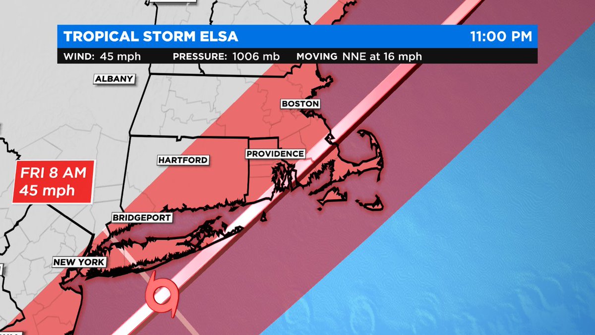
Tropical Storm Elsa thread for Boston area...
All signs point to a New England landfall for #Elsa mid/late Friday morning near Narragansett Bay, RI.
Two main threats: wind and rain. Storm surge not a widespread issue.
All signs point to a New England landfall for #Elsa mid/late Friday morning near Narragansett Bay, RI.
Two main threats: wind and rain. Storm surge not a widespread issue.

Your biggest direct impact really depends on where you compared to the track of the #Elsa.
On either side of the track to the S & E, wind is likely the biggest threat.
N & W of Boston, heavy rain + flooding is your concern.
On either side of the track to the S & E, wind is likely the biggest threat.
N & W of Boston, heavy rain + flooding is your concern.

Tropical Storm Elsa will likely bring some strong wind and heavy rain to parts of New England on Friday.
Much like a winter nor'easter, your exact impact will depend on the track of Elsa.

Much like a winter nor'easter, your exact impact will depend on the track of Elsa.

(1) Thread 3: Storm #Elsa
Forecast has swung back & forth between Tropical Storm (TS) & Cat 1 Hurricane this week.
Currently 65mph max sustained winds, with a chance of re-intensification. So, the H warnings remain.
#TurnAroundDontDrown
nhc.noaa.gov
🌀❄️👑

Forecast has swung back & forth between Tropical Storm (TS) & Cat 1 Hurricane this week.
Currently 65mph max sustained winds, with a chance of re-intensification. So, the H warnings remain.
#TurnAroundDontDrown
nhc.noaa.gov
🌀❄️👑


As #Elsa moves near or along the western Florida Peninsula through Wednesday, heavy rainfall may result in isolated flash, urban, and minor river flooding, with considerable flash and urban flooding possible in southwest and western portions of Florida. 

Mid to late week, heavy rainfall across coastal Georgia, South Carolina, North Carolina, and southeastern Virginia may result in isolated flash and urban flooding, with considerable flash and urban flooding possible across coastal Georgia and the Lowcountry of South Carolina 

Find and follow your local NWS forecast office at weather.gov/socialmedia.
Today we open the #NorthAfrica #MiddleEast #HornOfAfrica #GERD rainfall forecasts with some new plots, courtesy of @meteoblue. This first one is a 24 hour estimate of rainfall till 9pm today over Ethiopia.
Green = 1 inch of rain over the #Abo & #Abbay basins.
Green = 1 inch of rain over the #Abo & #Abbay basins.

This satellite data based plots shows estimated rainfall over the last three days of rainfall across North Africa. #DesertRain is falling across all the Sahel. In Sudan and Chad nearly an inch in the past three days. 

#Elsa is poised to landfall in #Cuba today, with TS force winds and heavy rain in tow. Flooding is a major concern. Next in line is the Florida coastline. If the core of this storm survives Cuba, re-intensification is possible before landfall in Florida. (1/4) #tropics #wxtwitter 


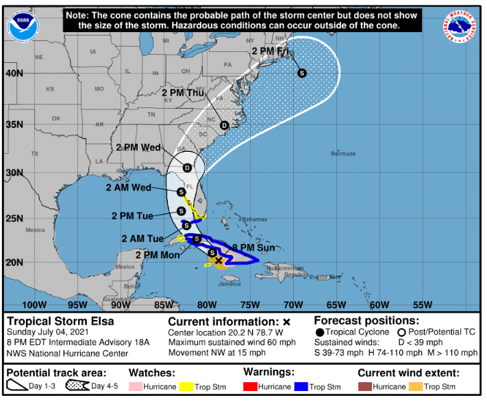
Attached to the first tweet are graphics that give some important information for those in the path of the storm and show the anticipated track and intensity. Do not underestimate a TS. Much damage to property can be expected associated with the wind and flooding. (2/4)
A snippet in regards to the storm *after* it moves through Cuba:
If Elsa can retain her core as it moves through Cuba, the storm faces a favorable trough interaction for ventilation and support of some deepening in pressure. Shear will likely play a factor, however (3/4) this
If Elsa can retain her core as it moves through Cuba, the storm faces a favorable trough interaction for ventilation and support of some deepening in pressure. Shear will likely play a factor, however (3/4) this
2 recent #pictures on day 5 of the 2021 Grand Ethiopian Renaissance Dam #GERD filling.
1. Satellite image this morning.
2 Date unknown, posted on Twitter today.
Meanwhile it looks as if the #HOA rain is about to get heavier. Today's forecasts follow.

1. Satellite image this morning.
2 Date unknown, posted on Twitter today.
Meanwhile it looks as if the #HOA rain is about to get heavier. Today's forecasts follow.


Today's big picture hasn't changed much.
TS #Elsa can still be seen bottom left, she will be crossing Cuba later today.
Bottom right we see storms over #Ethiopia and #Yemen.
In Europe the #EuropeBigWet continues with North Atlantic weather moving in from West.
TS #Elsa can still be seen bottom left, she will be crossing Cuba later today.
Bottom right we see storms over #Ethiopia and #Yemen.
In Europe the #EuropeBigWet continues with North Atlantic weather moving in from West.

#Elsa has pretty much done nothing but confuse meteorologists over the last 48 hours. The storm has acted in ways that were rather unexpected, and this is why forecast models are having a hard time handling the storm and therefore why intensify and forecast cones… (1/5)#tropics
have been so inconsistent. From rapidly intensifying in the MDR to moving 29 mph and still having a (somewhat) stacked core, to falling apart structurally and then exploding convection so much that it misleads most meteorologists into believing the storm… (2/5) #wxtwitter
was starting to intensify again when in reality it was only a CCC and the primary LLC was collapsing as a new one formed to the east and started moving southwest instead of northwest as it should have been given the steering flow in the area. Then it clears it’s CCC and… (3/5)
(1) Thread 2: Tropical Storm #Elsa
It would be a mistake to treat #TSElsa as if she's a sweet little princess and you can safely #LetItGo.
Even a tropical storm can be deadly like a hurricane. And this one looks like it will hug the coast from Florida to New Jersey, at least.
It would be a mistake to treat #TSElsa as if she's a sweet little princess and you can safely #LetItGo.
Even a tropical storm can be deadly like a hurricane. And this one looks like it will hug the coast from Florida to New Jersey, at least.

(2) Here is my first #Elsa thread, complete with shameless repetition of Frozen references, because it's not every day you get a fun storm name to use for a few weeks. Next up are #Fred and #Grace.
(3) TS #Elsa update - Sunday evening
Cautiously optimistic about some nuanced changes to the latest forecast. Looks like Elsa will be a TD (Tropical Depression) while moving NNE after Florida & will veer back out to sea once reaching the mid-Atlantic US coast.
Cautiously optimistic about some nuanced changes to the latest forecast. Looks like Elsa will be a TD (Tropical Depression) while moving NNE after Florida & will veer back out to sea once reaching the mid-Atlantic US coast.
(1) Thread #6: #SurfsideBuildingCollapse
I called it early on. This event has a ripple effect across the US for emergency management, public safety policy, and infrastructure. The "built environment."
My Surfside thread directory:
I called it early on. This event has a ripple effect across the US for emergency management, public safety policy, and infrastructure. The "built environment."
My Surfside thread directory:
(2) I'm not "tooting my own horn." I'm doing what anyone else would do when they have information that others might not have, that could save one life, let alone hundreds of lives.
This building collapse is not new or unusual to folk outside the US who witnessed similar events.
This building collapse is not new or unusual to folk outside the US who witnessed similar events.
(3) It's true that most people would believe "buildings don't just fall down in America," and in most cases, they are right. There are stringent standards and liability laws in the US.
But statistically, someone always lets the side down. It's human nature.
But statistically, someone always lets the side down. It's human nature.
The convective storms over Ethiopia and Sudanese Nile Basins tonight is remarkably intense. Bringing massive amounts of rain across a huge area, including the #Abbay /#BlueNile basin, on the 4th day of #GERD filling.
Today's #HOA #ME and #NorthAfrica rainfall forecasts follow.
Today's #HOA #ME and #NorthAfrica rainfall forecasts follow.
In this wider view you can see the full size of today's rain areas which extended deep into Sudan later in the afternoon.
These two images are at sunset the sizes of the two large convective areas, the eastern one extends well north into Eritrea and covers Tigray and the entire #Abbay Basin. The first image provides an idea of size. Each storm area is larger than the UK and Ireland. 


Hurricane #Elsa this morning shortly before daybreak. The track of this increasingly dangerous looking cyclone has moved east and north with a projected path over Cuba now.
Here is the latest official warnings and advice. Elsa is moving very fast and is currently forecast to exit the U.S. after making landfall in 5 days time. However these events are inherently unpredictable. See .... nhc.noaa.gov 

This animation shows water vapour over the Caribbean over the next five days. The center of Elsa can be seen in purple.
(1) Thread #1: #HurricaneElsa
Last night I almost started this thread as TS #Elsa and I'm glad I didn't.
Now a Cat 1 hurricane, and it's too early to predict much else for FL and surrounding states.
Last night I almost started this thread as TS #Elsa and I'm glad I didn't.
Now a Cat 1 hurricane, and it's too early to predict much else for FL and surrounding states.
(2) It would be a mistake to treat Hurricane Elsa as if she's a sweet little princess and you can safely #LetItGo.
Even a tropical storm can be deadly like a hurricane.
Even a tropical storm can be deadly like a hurricane.

And then around midday. In Levi (@TropicalTidbits) commentary he mentions several times how fast the storm is moving. And this becomes apparent in these animations.
And this is also pertinent in relation to the hazard's #Elsa #TSElsa potentially poses as she strengthens.
And this is also pertinent in relation to the hazard's #Elsa #TSElsa potentially poses as she strengthens.
Levi also talks about the GFS (U.S. @NOAA) and European (@ECMWF) models disagreeing on track/guidance. Here's the latest GFS model forecast for the Caribbean. In it the storm does not strengthen a great deal. But it does reach the Gulf of Mexico by Tuesday. I.E. Elsa is moving.
This animation shows a PWAT (Precipitable water) simulation for the same period, through to a potential landfall on Wednesday/Thursday. I was curious to see how much #Elsa would gather together and influence the PWAT distribution. And it appears she will do so.
(1) And so it begins. #HWStormWatch🇺🇸🌀
Hurricane #Bill got a name but he's of no concern to me.
It's the future Hurricane #Claudette⚜️, (lovely Cajun name) that means y'all in her path must get #prepping today.
#Danny #Elsa #Fred #Grace next nhc.noaa.gov/gtwo.php?basin…
Hurricane #Bill got a name but he's of no concern to me.
It's the future Hurricane #Claudette⚜️, (lovely Cajun name) that means y'all in her path must get #prepping today.
#Danny #Elsa #Fred #Grace next nhc.noaa.gov/gtwo.php?basin…

(2) Why on earth would a Kiwi fan of Margaret Thatcher be interested in US Gulf and Atlantic coast hurricanes?
Several reasons, but we'll start with being an earthquake survivor. (2011, NZ, 185 deaths in my city.)
It changed my life.
Several reasons, but we'll start with being an earthquake survivor. (2011, NZ, 185 deaths in my city.)
It changed my life.
(3) Earthquakes can't be predicted. Anyone who claims they can is trying to scam you.
Hurricanes CAN be predicted.
So instead of despairing at the death toll each time, I promote #readiness and I fight #disinformation too.
Hurricanes CAN be predicted.
So instead of despairing at the death toll each time, I promote #readiness and I fight #disinformation too.
Am having the most amazing Edinburgh and have genuinely found something to love in every show I’ve seen. Top picks below
#SkinACatPlay by the amazingly talented and frank @IsleyLynn
#UlsterAmerican which made me laugh and #Class which made me weep and weep @theplayisCLASS both @traversetheatre


