Discover and read the best of Twitter Threads about #alwx
Most recents (10)
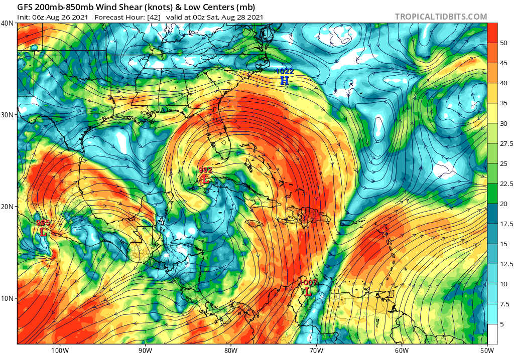
In the Gulf of Mexico, #99L's track will be set in part by its intensity.
An area-averaged sounding around the storm reveals subtle differences in low vs mid/upper-level steering.
A stronger storm wld feel SSE winds ~300mb and move more to the N resulting in landfall farther E.
An area-averaged sounding around the storm reveals subtle differences in low vs mid/upper-level steering.
A stronger storm wld feel SSE winds ~300mb and move more to the N resulting in landfall farther E.

With ocean temperatures approaching 30C, no dry air in sight and near total command of the upper-level wind field, it's honestly hard to see a scenario where #99L doesn't rapidly intensify in the Gulf.
So watch out for potential further shifts east in the forecast track.

So watch out for potential further shifts east in the forecast track.


Ways to help those affected by severe weather yesterday across the South: a THREAD
#alwx #gawx #wxtwitter
⬇️⬇️⬇️
#alwx #gawx #wxtwitter
⬇️⬇️⬇️
Supply drive at Hale County High School / Middle School #alwx 

Donating money or needed items to Calhoun County (info below) #alwx
Starting a thread of PUBLIC STORM SHELTER info for those who are at risk of tornadoes and damaging straight-line winds today.
#ALwx #MSwx #TNwx #tornadoshelter #publicshelter #stormshelter
#ALwx #MSwx #TNwx #tornadoshelter #publicshelter #stormshelter
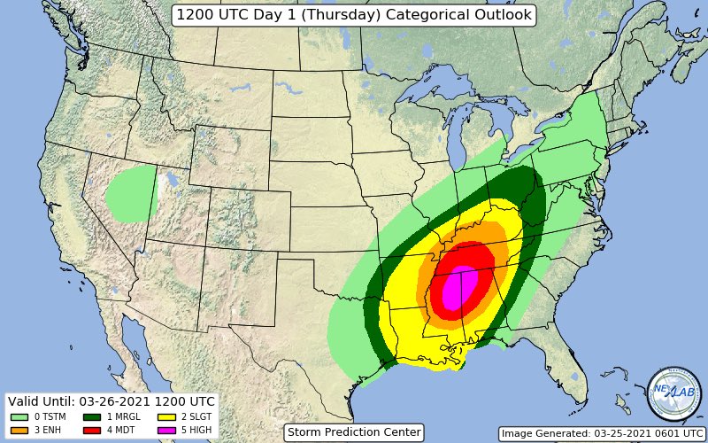
BREAKING: @NWSSPC IS FORECASTING A #TORNADO OUTBREAK IN #MISSISSIPPI #ALABAMA & #TENNESSEE THURSDAY!
SPC Issued "HIGH RISK" Of Severe Weather-"SEVERAL LONG-TRACK STRONG TORNADOES, DESTRUCTIVE WINDS & VERY LARGE HAIL"...This Is A Particulary Dangerous Situation! #mswx #alwx #tnwx

SPC Issued "HIGH RISK" Of Severe Weather-"SEVERAL LONG-TRACK STRONG TORNADOES, DESTRUCTIVE WINDS & VERY LARGE HAIL"...This Is A Particulary Dangerous Situation! #mswx #alwx #tnwx


CONT: Compare The Newly Issued "High Risk" Area From The @NWSSPC To Earlier Issued Forecast From @nadocast.
Nadocast Has The Bulls-eye Centered More Over N. #Alabama.
This Is Similar To My Early Forecast For A Number Of Reasons.
Either Way Long-Track Tornadoes Region-Wide!

Nadocast Has The Bulls-eye Centered More Over N. #Alabama.
This Is Similar To My Early Forecast For A Number Of Reasons.
Either Way Long-Track Tornadoes Region-Wide!


CONT: The 00Z 3km NAM Model Based "Significant Tornado Parameter"-(STP) Has One Of The Largest "Maxed Out" Areas In Memory.
The Threat Of This Severe Weather Scenario Including The Long-Tracked Strong #Tornado Risk ➡Cannot Be Over-Sold!⬅
The Threat Of This Severe Weather Scenario Including The Long-Tracked Strong #Tornado Risk ➡Cannot Be Over-Sold!⬅

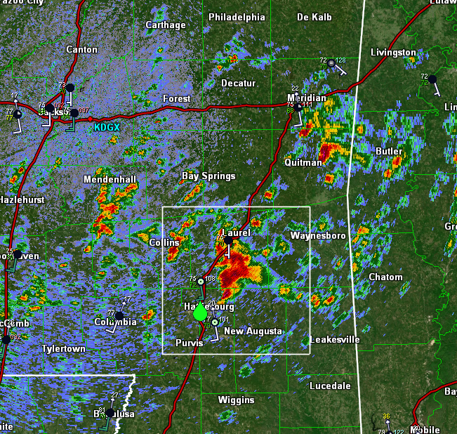
Cell near Hattiesburg #MSwx has rapidly punched up to about 50,000 feet which means it has broken through the capping inversion.
It is already exhibiting rotation on radar and is likely not far off from producing severe weather given the very favorable environment.

It is already exhibiting rotation on radar and is likely not far off from producing severe weather given the very favorable environment.


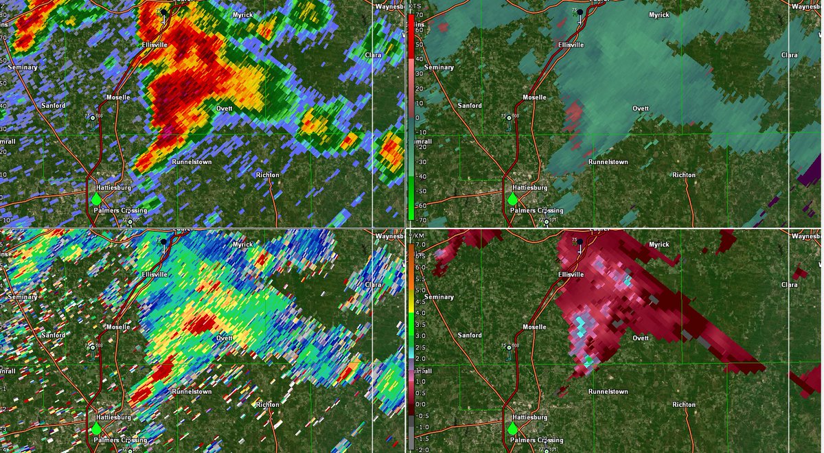
Looking at dual-pol data (ZDR bottom left), it appears this cell is already size-sorting raindrops with highest ZDR values along the forward flank gust front and lower ZDR values farther west/NW of the mesocyclone.
This helps infer the presence of rotation within the storm.
This helps infer the presence of rotation within the storm.

[11:49 AM EST 3/17/21] - looks like we have two strong mesocyclones in SE #MSwx, one near Sandersville and the other south of Myrick.
No warnings on these cells yet as rotation isn't strong enough to support a tornado as of now, but these cells are two to keep a close eye on.
No warnings on these cells yet as rotation isn't strong enough to support a tornado as of now, but these cells are two to keep a close eye on.

(1/x) National media, my name is Josh. I am here to help you cover this story accurately.
1. January tornadoes are not rare in Alabama. Here are the number of tornadoes we've had in the past 5 Januarys:
1/2020: 5
1/2019: 5
1/2018: 0
1/2017: 21
1/2016: 0
31 in 5 years. #alwx
1. January tornadoes are not rare in Alabama. Here are the number of tornadoes we've had in the past 5 Januarys:
1/2020: 5
1/2019: 5
1/2018: 0
1/2017: 21
1/2016: 0
31 in 5 years. #alwx
2. This tornado did NOT hit without warning. A Tornado WARNING was issued 8-10 minutes before it hit. A Tornado Watch was issued hours prior
If you want to say it hit with little warning, OK.
If you want to say that some people in the path didn't get the warning, OK.
If you want to say it hit with little warning, OK.
If you want to say that some people in the path didn't get the warning, OK.
3. If you air sound from people who say it hit without warning, that's still bad journalism.
If you interview me & I tell you that Papa Smurf sent the storms to take over our mayonnaise supply, you won't air it. Because it's not true.
This matters because its harmful. #alwx
If you interview me & I tell you that Papa Smurf sent the storms to take over our mayonnaise supply, you won't air it. Because it's not true.
This matters because its harmful. #alwx
(THREAD) If you missed the FB Live, there were 3 very important clues that a tornado was imminent north of Birmingham last night. And @NWSBirmingham saw those clues, reacted quickly, and provided a world-class, lifesaving service to the people in the tornado's path...#alwx
First, there was a pocket of enhanced helicity over northeast Alabama...likely a remnant of the "wedge" front that had brought cooler air into north Georgia and NE Alabama. See that bullseye over Rome, GA? It extends back towards Birmingham. #alwx 

Secondly, the reflectivity data showed this storm "tilt" - the overall line was clearly oriented from SW to NE, but just before the tornado formed, it assumed a more S to N orientation. This is often a clue that a QLCS/embedded supercell is about to produce a tornado. #alwx
To the people of AL, know that we’re using every available asset & resource at the state level to support you in recovery. I assure you that we’ll be there for you as we start rebuilding our homes, businesses & communities over the coming days, weeks & months. #alwx #alpolitics
For those who’ve been directly touched by this storm, your fellow Alabamians are praying for you, & we stand ready to support you in every way humanly possible. I will visit some of our hardest hit areas & assess the damage firsthand when it is safe to do so. #alwx #alpolitics
I’ve been in frequent communication with our friends from @alabamapower & @powersouth. They hope to get their crews out today. Yesterday’s weather made it almost impossible to do anything more than provide power to hospitals, water systems & the like. #alwx #alpolitics
We're here to provide a briefing on #HurricaneSally, to share what’s been done so far & to discuss what we’re currently doing to hopefully keep our citizens safe as this slow-moving storm makes landfall later tonight. #alwx #alpolitics @AlabamaEMA @NWS
@AlabamaEMA @NWS Yesterday, I talked w/ @RepByrne as well as the various mayors & county commission chairmen, & offered every assistance humanly possible. Luckily, our local partners are also experienced leaders in emergency management. We’ll be there standing shoulder-to-shoulder with them.
The @WhiteHouse & the Trump Administration have been great to our state. They’ve been in constant communication with my office, & we greatly appreciate their offer to assist where possible & for them keeping an eye on Alabama. @POTUS #alwx #alpolitics
Please download these apps now if you are in the path of #HurricaneMichael. Later, when there is no electricity, may be too late. Remember, there are no street signs in flooded areas.
(h/t @CEDRdigital)
#HurricaneMichael2018 #HurricaneResources
(h/t @CEDRdigital)
#HurricaneMichael2018 #HurricaneResources
Please follow these instructions NOW so you can find the geo-coordinates to your location in the event you ever need rescue. Lets do this BEFORE there's an emergency.
(h/t @CEDRdigital)
#HurricaneMichael #HurricaneMichael2018 #HurricaneResources
(h/t @CEDRdigital)
#HurricaneMichael #HurricaneMichael2018 #HurricaneResources

