Discover and read the best of Twitter Threads about #MSwx
Most recents (18)
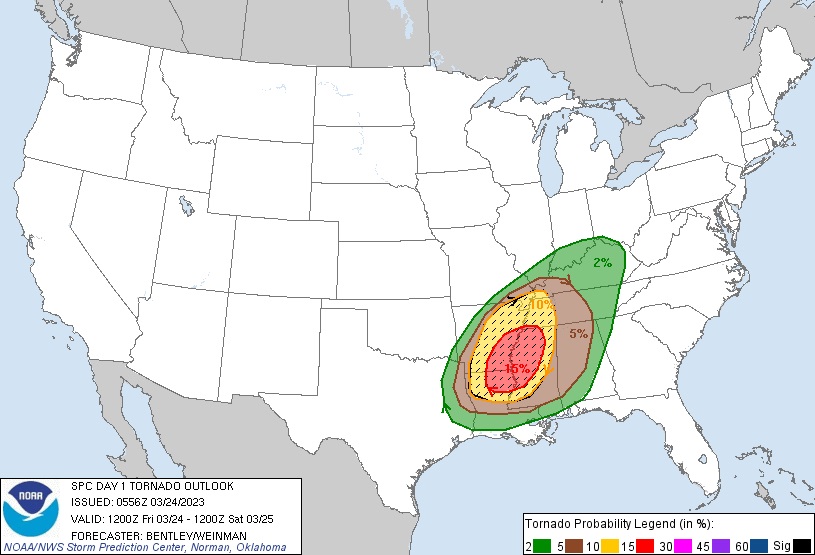
Les USA seront aujourd'hui concernés par un épisode orageux majeur : un Moderate risk (risque 4/5) a été émis par le SPC.
Le risque de tornade de forte intensité (EF2+) est élevé, avec un possible outbreak dans la soirée.
J'essaierai de suivre au maximum cet épisode ⬇️


Le risque de tornade de forte intensité (EF2+) est élevé, avec un possible outbreak dans la soirée.
J'essaierai de suivre au maximum cet épisode ⬇️


John Humphress on @MyRadarWX giving us live coverage of #ida in Grand Isle — #HurricaneIda #lawx #mswx
2/ John Humphress on @MyRadarWX live in Grand Isle — floating debris now— looks like part of a stairway. #ida #HurricaneIda #lawx #mswx
3/ Listen to the winds—John Humphress on @MyRadarWX live coverage of #Ida intensifying in Grand Isle #lawx #mswx #hurricaneida
There is some confusion surrounding the impacts that will occur across our area. Here is a breakdown of all the impacts we are expecting from Hurricane #Ida below by area/region. #Ida is a dangerous hurricane and it WILL produce LIFE-THREATENING impacts. #mswx #lawx
For the Baton Rouge metro area: Expect winds >110mph sustained. Rainfall 10-15” with 20”+ possible. Brief tornadoes possible. #lawx 


For the River Parishes: Expect winds >110mph sustained. Rainfall 10-15” with 20”+ possible. Brief tornadoes possible. 5-8 ft of inundation in Lake Pontchartrain. #lawx 


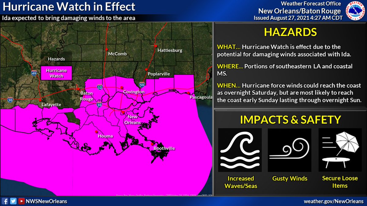
We continue to monitor Ida as it approaches, expected to make landfall Sunday afternoon/evening. A hurricane Warning is in effect for areas of southern/central LA. A Tropical Storm Warning is in effect for parts of coastal/southern MS and western LA. #LAwx #MSwx 

🌀 4AM CT Tropical Storm Ida Thread: Ida continues northwest south of Cuba, expected to enter into the SE Gulf tonight/early Saturday. Ida remains on track to become a major hurricane, delivering significant impacts to portions of southern LA and southern MS. #lawx #mswx (1/5) 

🌀 As we gear up for the potential impacts from TD9 which could be #Ida later today or tonight there are a few thing we would like everyone to understand and be prepared for. #LAwx #MSwx 

💆 DO NOT PANIC! Be prepared, stay up to date, and try to remain calm. You have time IF you begin today. If the track continues as forecast, conditions will likely begin to go downhill late Saturday. This gives you today, Friday, & even early Saturday. #LAwx #MSwx 

Make sure you get your information from reliable sources. Federal sources are @NWS @NWSLakeCharles @NWSJacksonMS @NWSShreveport @NWSMobile @NWSHouston @NHC_Atlantic @NWSWPC @NWSSPC @fema @femaregion4 @FEMARegion6 #LAwx #MSwx 


Starting a thread of PUBLIC STORM SHELTER info for those who are at risk of tornadoes and damaging straight-line winds today.
#ALwx #MSwx #TNwx #tornadoshelter #publicshelter #stormshelter
#ALwx #MSwx #TNwx #tornadoshelter #publicshelter #stormshelter
BREAKING: @NWSSPC IS FORECASTING A #TORNADO OUTBREAK IN #MISSISSIPPI #ALABAMA & #TENNESSEE THURSDAY!
SPC Issued "HIGH RISK" Of Severe Weather-"SEVERAL LONG-TRACK STRONG TORNADOES, DESTRUCTIVE WINDS & VERY LARGE HAIL"...This Is A Particulary Dangerous Situation! #mswx #alwx #tnwx

SPC Issued "HIGH RISK" Of Severe Weather-"SEVERAL LONG-TRACK STRONG TORNADOES, DESTRUCTIVE WINDS & VERY LARGE HAIL"...This Is A Particulary Dangerous Situation! #mswx #alwx #tnwx
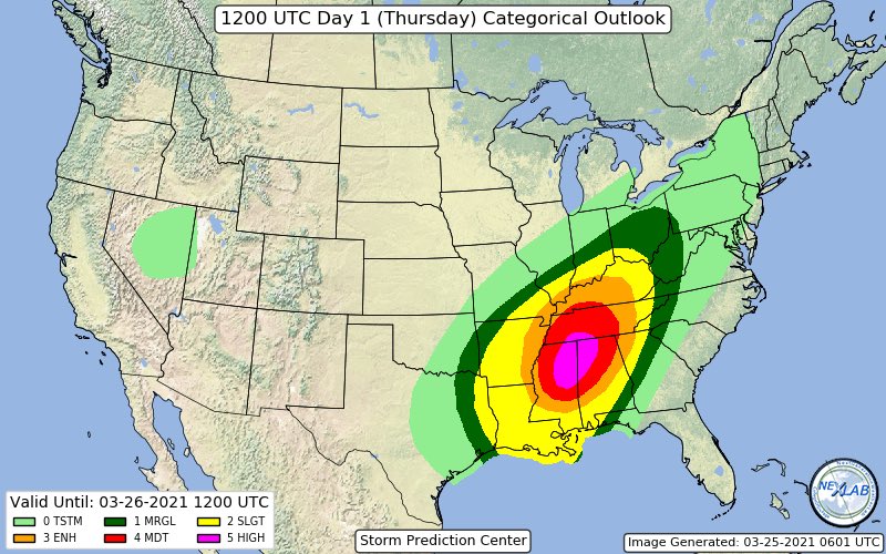

CONT: Compare The Newly Issued "High Risk" Area From The @NWSSPC To Earlier Issued Forecast From @nadocast.
Nadocast Has The Bulls-eye Centered More Over N. #Alabama.
This Is Similar To My Early Forecast For A Number Of Reasons.
Either Way Long-Track Tornadoes Region-Wide!

Nadocast Has The Bulls-eye Centered More Over N. #Alabama.
This Is Similar To My Early Forecast For A Number Of Reasons.
Either Way Long-Track Tornadoes Region-Wide!


CONT: The 00Z 3km NAM Model Based "Significant Tornado Parameter"-(STP) Has One Of The Largest "Maxed Out" Areas In Memory.
The Threat Of This Severe Weather Scenario Including The Long-Tracked Strong #Tornado Risk ➡Cannot Be Over-Sold!⬅
The Threat Of This Severe Weather Scenario Including The Long-Tracked Strong #Tornado Risk ➡Cannot Be Over-Sold!⬅

Cell near Hattiesburg #MSwx has rapidly punched up to about 50,000 feet which means it has broken through the capping inversion.
It is already exhibiting rotation on radar and is likely not far off from producing severe weather given the very favorable environment.

It is already exhibiting rotation on radar and is likely not far off from producing severe weather given the very favorable environment.
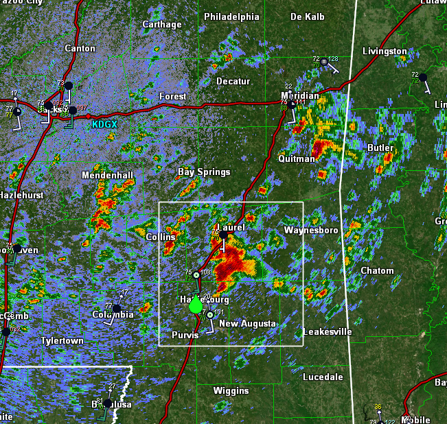

Looking at dual-pol data (ZDR bottom left), it appears this cell is already size-sorting raindrops with highest ZDR values along the forward flank gust front and lower ZDR values farther west/NW of the mesocyclone.
This helps infer the presence of rotation within the storm.
This helps infer the presence of rotation within the storm.
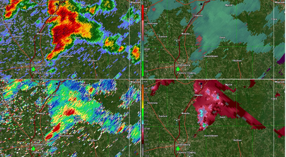
[11:49 AM EST 3/17/21] - looks like we have two strong mesocyclones in SE #MSwx, one near Sandersville and the other south of Myrick.
No warnings on these cells yet as rotation isn't strong enough to support a tornado as of now, but these cells are two to keep a close eye on.
No warnings on these cells yet as rotation isn't strong enough to support a tornado as of now, but these cells are two to keep a close eye on.

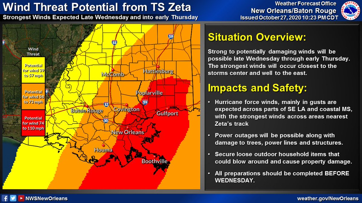
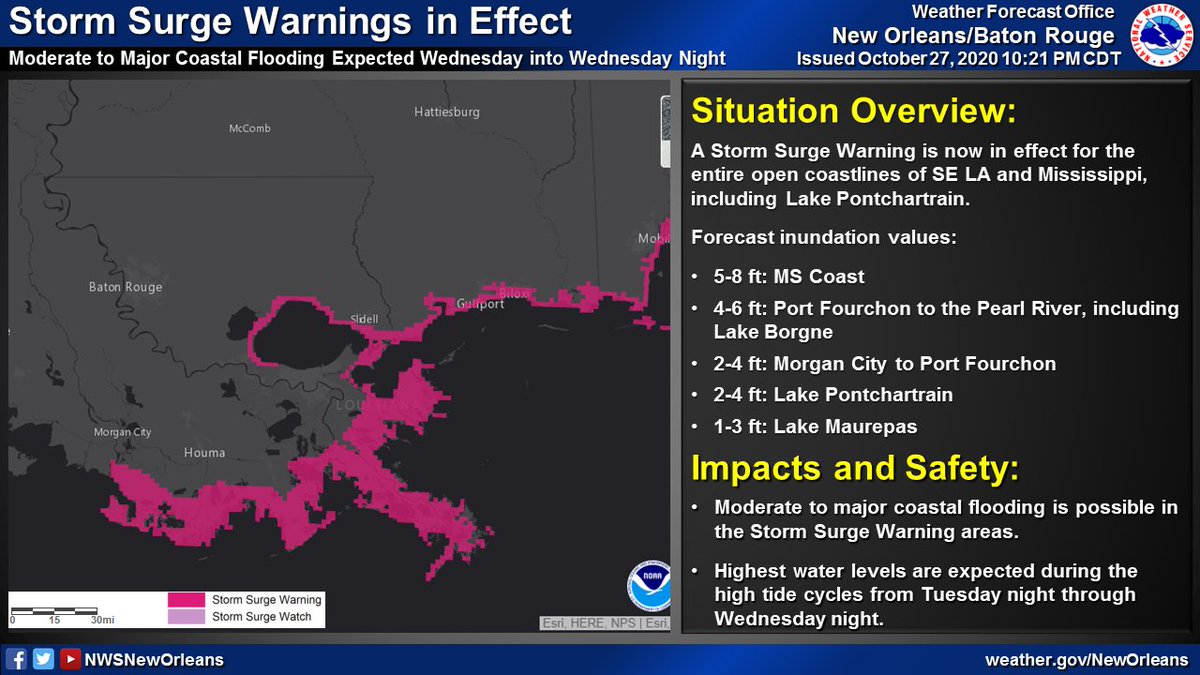
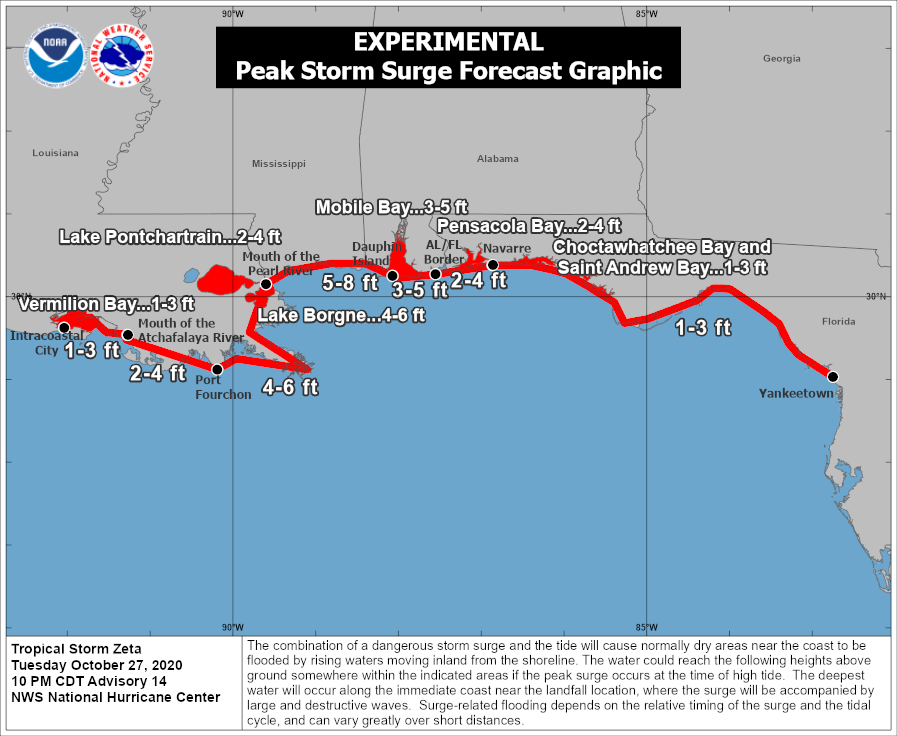
🌀10PM CDT Update on Tropical Storm #Zeta. Starting to see some steady strengthening trend now with max winds at 70mph. Impacts across parts of SE LA and southern MS remain likely on Wednesday.
Lets break down each specific threat one at a time...(1/6)
Lets break down each specific threat one at a time...(1/6)

(1/6) 🌀 7PM CDT Update on Hurricane #Zeta. No major changes this evening as #Zeta continues towards the NW with an eventual, brief landfall expected across the Yucatan later tonight. We are still anticipating impacts, some major across the area Wed & Thu. Stay tuned! #lawx #mswx 

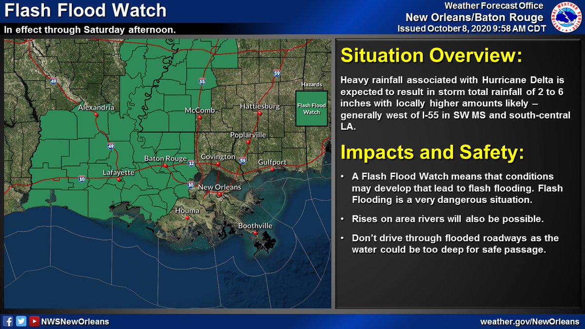
🌀 (1/5): Here's the latest with Hurricane #Delta as of 10AM CDT. Some slight strengthening was noted by recent aircraft recon observations with a steady strengthening trend now expected through the day today. Impacts still remain likely across our area Friday. #lawx #mswx 


Here is the 4AM update on Hurricane #Delta along with a thread on the latest local hazards expected from Hurricane #Delta.
Delta will bring potential for:
🌊Life-threatening storm surge flooding
🌬️Damaging winds
⛈️Heavy rain and flash flooding
#lawx #mswx
(1/5)
Delta will bring potential for:
🌊Life-threatening storm surge flooding
🌬️Damaging winds
⛈️Heavy rain and flash flooding
#lawx #mswx
(1/5)

Here's a thread on the latest local hazards expected from Hurricane #Delta.
Delta will bring potential for:
🌊 Life-threatening storm surge flooding
🌬️ Damaging winds
🌧️ Heavy rain and flash flooding
#lawx #mswx
(1/5)
Delta will bring potential for:
🌊 Life-threatening storm surge flooding
🌬️ Damaging winds
🌧️ Heavy rain and flash flooding
#lawx #mswx
(1/5)

🌀 (1/6): Tweet thread with the latest on Hurricane #Delta. The 10AM position has #Delta continuing to cross the Yucatan & will emerge into the Gulf later today. No major changes to the forecast track as impacts, some significant, may be likely later this week/weekend #lawx #mswx 

🌀 (1/3) 10AM CDT Update on TS #Delta: Delta is now a major hurricane in the west-central Caribbean. No major changes to the forecast track as impacts remain likely along the northern Gulf coast late this week and this weekend. #lawx #mswx 

🌀 (2/3) As a reminder, NOW is the time to have a plan! Don't let the recent cool temperatures fool you - it is still Hurricane Season! Impacts remain likely with this system across portions of the northern Gulf coast and you should take it seriously! #lawx #mswx 


🌀 (3/3) Do you know which NWS office serves your area? Our neighbors include @NWSLakeCharles to our west including SW LA, @NWSJacksonMS to the north across most of MS, & @NWSMobile to our E including the AL/FL beaches. Follow your local office for the latest updates! #lawx #mswx 

Here's a thread with the latest on Hurricane #Laura. It continues to strengthen as it moves toward the NW Gulf Coast. Minor to moderate impacts are expected across portions of SE LA and S MS. #lawx #mswx (1/5) 

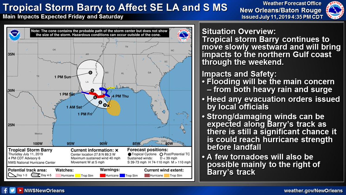
(1/6) 5:15p Thu TS #Barry Update
🌧️🌊Flooding continues to be the greatest threat - both from heavy rain and storm surge
🌬️Strong/Damaging winds possible along Barry's track as it could still become a hurricane
🌪️A few tornadoes possible, especially near the coast
#lawx #mswx
🌧️🌊Flooding continues to be the greatest threat - both from heavy rain and storm surge
🌬️Strong/Damaging winds possible along Barry's track as it could still become a hurricane
🌪️A few tornadoes possible, especially near the coast
#lawx #mswx
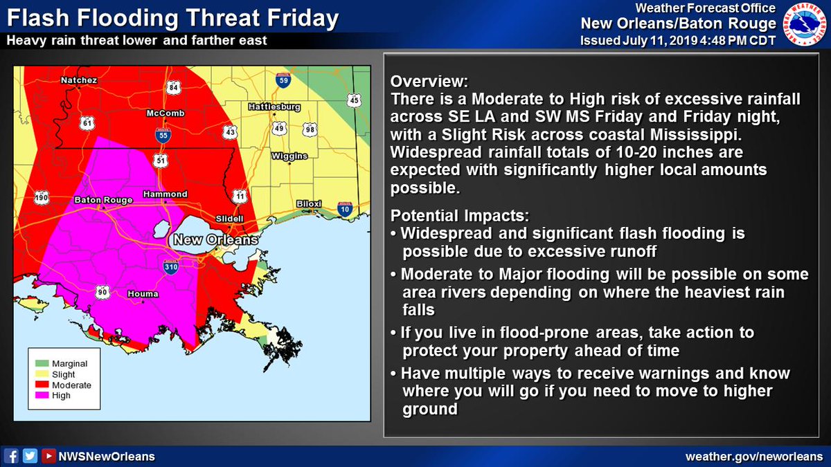
(2/6) Significant flood threat associated w/ #Barry
📏10-20" of rain with significantly higher local amounts possible
⏰Heaviest rain expected Friday through Saturday night
🌧️Heavy rain could lead to widespread/life-threatening flash flooding and moderate to major river flooding
📏10-20" of rain with significantly higher local amounts possible
⏰Heaviest rain expected Friday through Saturday night
🌧️Heavy rain could lead to widespread/life-threatening flash flooding and moderate to major river flooding
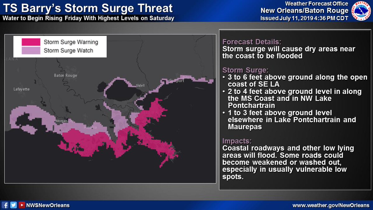
(3/6) TS #Barry will result in a storm surge threat across SE LA and coastal MS
📏3-6 ft of inundation possible along open coast of SE LA
⏰Water levels begin rising Friday with highest levels on Saturday
🌊Storm surge will flood coastal roadways and other low lying areas
📏3-6 ft of inundation possible along open coast of SE LA
⏰Water levels begin rising Friday with highest levels on Saturday
🌊Storm surge will flood coastal roadways and other low lying areas
