Discover and read the best of Twitter Threads about #LAwx
Most recents (24)
The before & after pictures of Grand Isle, #Louisiana after #Ida. Looks really grimacing. #LAwx #HurricaneIda #Tropics 

And please note, we did not take this. The owner of this is unknown as well. We will update you who this was & give credit to the person responsible.
UPDATE: Credits go to @nytimes for the image above.
Well this day is going great. My car battery died TODAY.
Nevertheless, now I'm at @LouisianaGov's press conference about Hurricane Ida.
Nevertheless, now I'm at @LouisianaGov's press conference about Hurricane Ida.
.@LouisianaGov says there are significant storm surge impacts around Port Fourchon and in Plaquemines Parish. #lalege #lagov
.@LouisianaGov repeatedly says that no one should be out on the roads or out of their house during the storm and in the immediate aftermath of the storm. #lalege #lagov
Here's a group of local Louisiana journalists who stayed in the state for Hurricane Ida to provide coverage on the ground during and after the storm. (I am also here in Baton Rouge for the storm.)
Give us a follow for reliable info. #lawx #lalege #ida #hurricaneida
Give us a follow for reliable info. #lawx #lalege #ida #hurricaneida
These journalists aren't in any particularly order:
@remroc15, @JC_Canicosa, @WesleySMuller, @yawn_meister, @NewsieDave, @DCMonteverde, @harrisongolden, @ArielSalk, @johnstonvon, @ShannonHeckt, @Charles_Lussier, @emily_woodruff_, @AubriRuth, @rc_nelsen ....
@remroc15, @JC_Canicosa, @WesleySMuller, @yawn_meister, @NewsieDave, @DCMonteverde, @harrisongolden, @ArielSalk, @johnstonvon, @ShannonHeckt, @Charles_Lussier, @emily_woodruff_, @AubriRuth, @rc_nelsen ....
John Humphress on @MyRadarWX giving us live coverage of #ida in Grand Isle — #HurricaneIda #lawx #mswx
2/ John Humphress on @MyRadarWX live in Grand Isle — floating debris now— looks like part of a stairway. #ida #HurricaneIda #lawx #mswx
3/ Listen to the winds—John Humphress on @MyRadarWX live coverage of #Ida intensifying in Grand Isle #lawx #mswx #hurricaneida
11PM update on #Ida is in from NHC.
Winds still steady at 105mph as the pressure falls to 964mb.
Satellite presentation continues to improve, but we'll have to wait until the next recon plane arrives in a few hours to see whether that's translating to stronger winds.
Winds still steady at 105mph as the pressure falls to 964mb.
Satellite presentation continues to improve, but we'll have to wait until the next recon plane arrives in a few hours to see whether that's translating to stronger winds.
Winds haven't come up as much as anticipated today, due largely to some lingering chaos in the inner core after Cuba.
But the storm has picked up tons of energy, dropping its central pressure by >20mb and pushing hurricane force winds dozens of miles from the center.
But the storm has picked up tons of energy, dropping its central pressure by >20mb and pushing hurricane force winds dozens of miles from the center.
All environmental and satellite indicators continue to point towards rapid intensification tonight.
That's what folks should expect and plan on.
Regardless of what max winds a few spots see in the eyewall, surge and rain will be catastrophic.
That's what folks should expect and plan on.
Regardless of what max winds a few spots see in the eyewall, surge and rain will be catastrophic.
There is some confusion surrounding the impacts that will occur across our area. Here is a breakdown of all the impacts we are expecting from Hurricane #Ida below by area/region. #Ida is a dangerous hurricane and it WILL produce LIFE-THREATENING impacts. #mswx #lawx
For the Baton Rouge metro area: Expect winds >110mph sustained. Rainfall 10-15” with 20”+ possible. Brief tornadoes possible. #lawx 


For the River Parishes: Expect winds >110mph sustained. Rainfall 10-15” with 20”+ possible. Brief tornadoes possible. 5-8 ft of inundation in Lake Pontchartrain. #lawx 


.@LouisianaGov has started his afternoon update on Hurricane Ida. You can watch it live here: #lalege #lagov
"This is a very strong storm." - @LouisianaGov.
He says winds will be at 140 mph when Hurricane Ida makes landfall.
Almost the entire state is under some type of warning or watch. #lalege #lagov
He says winds will be at 140 mph when Hurricane Ida makes landfall.
Almost the entire state is under some type of warning or watch. #lalege #lagov
Once again, @LouisianaGov is saying we could be seeing 110 mph winds in Baton Rouge, Lafayette, New Orleans and River parishes. #lalege #lagov
When Ida meets delta....I've put together a list of the ways Louisiana's delta surge complicates the current hurricane prep and response.
lailluminator.com/2021/08/28/whe… #COVID19 #lawx #lalege #lagov
lailluminator.com/2021/08/28/whe… #COVID19 #lawx #lalege #lagov
How hurricane response is different because of the #COVID19 delta surge:
➡️Evacuating hospitals is "impossible"
➡️State shelters have fewer beds
➡️Nursing homes can't send fragile patients to hospitals
lailluminator.com/2021/08/28/whe… #lalege #lagov
➡️Evacuating hospitals is "impossible"
➡️State shelters have fewer beds
➡️Nursing homes can't send fragile patients to hospitals
lailluminator.com/2021/08/28/whe… #lalege #lagov
Hospitals are full in and around Louisiana so there's nowhere to transfer patients if a hospital was damaged/lost water because of Hurricane Ida.
“We don’t have any place to bring those patients — not in state, not out of state.” - @LouisianaGov
lailluminator.com/2021/08/28/whe… #lalege
“We don’t have any place to bring those patients — not in state, not out of state.” - @LouisianaGov
lailluminator.com/2021/08/28/whe… #lalege
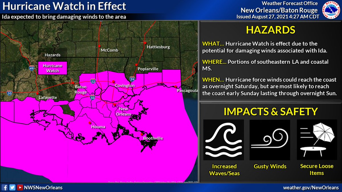
We continue to monitor Ida as it approaches, expected to make landfall Sunday afternoon/evening. A hurricane Warning is in effect for areas of southern/central LA. A Tropical Storm Warning is in effect for parts of coastal/southern MS and western LA. #LAwx #MSwx 

.@LouisianaGov is starting his press conference on Hurricane Ida (and COVID...and whatever other disaster we are currently having.) #lalege #lagov
Today is the one year anniversary of Hurricane Laura and Louisiana is facing another CATEGORY 4 hurricane. #lalege #lagov
Hurricane Ida is supposed to make landfall between St. Mary's and Terrebonne parishes. @LouisianaGov says people need to be where they are going to be for the storm by nightfall tomorrow night. #lalege #lagov
Unfortunately, #Ida has continued to rapidly intensify this afternoon and is now an 80mph hurricane.
Cloud tops have warmed somewhat in the last hour or so as we approach DMIN and the center passes over the Isle of Youth.
This is expected, and doesn't preclude more RI tomorrow.
Cloud tops have warmed somewhat in the last hour or so as we approach DMIN and the center passes over the Isle of Youth.
This is expected, and doesn't preclude more RI tomorrow.
The official NHC forecast for #Ida now calls for landfall in SE #LAwx as a 140mph Cat 4.
The storm is overperforming intensity predictions, a trend that may well continue over the weekend.
Plan as if this could be a Category Five. Even if it's not, it may well feel like it.
The storm is overperforming intensity predictions, a trend that may well continue over the weekend.
Plan as if this could be a Category Five. Even if it's not, it may well feel like it.

Also remember that a storm's category only reflects the winds experienced by a few spots on the immediate coast.
The greater threat for most of #LAwx is water.
15-20" of rain and 10-15 feet of storm surge will strain even the best flood control systems.

The greater threat for most of #LAwx is water.
15-20" of rain and 10-15 feet of storm surge will strain even the best flood control systems.
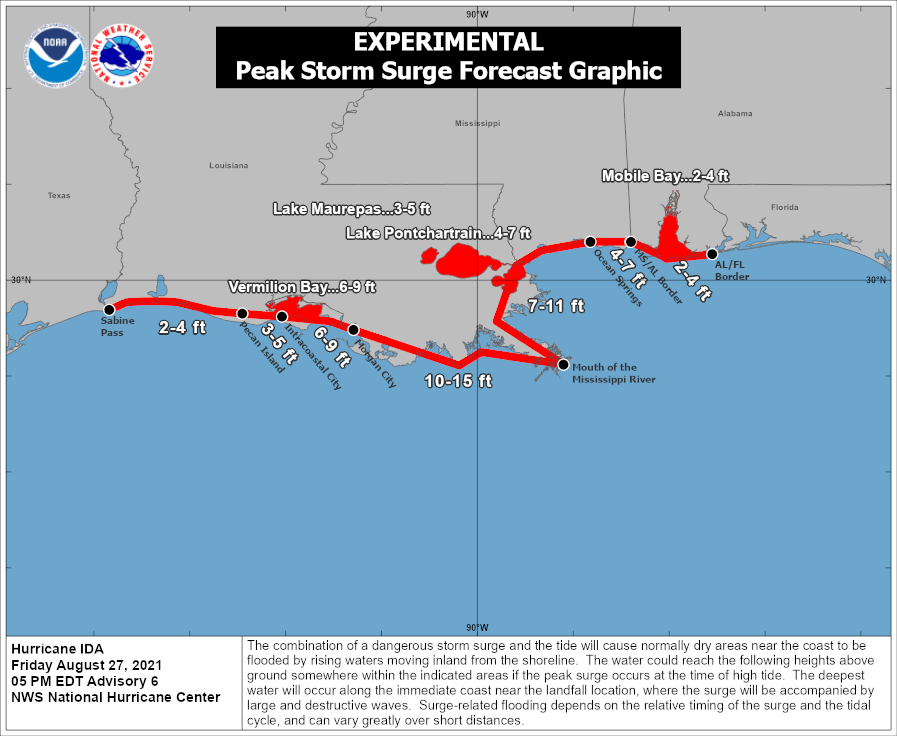

🌀 4AM CT Tropical Storm Ida Thread: Ida continues northwest south of Cuba, expected to enter into the SE Gulf tonight/early Saturday. Ida remains on track to become a major hurricane, delivering significant impacts to portions of southern LA and southern MS. #lawx #mswx (1/5) 

🌀 As we gear up for the potential impacts from TD9 which could be #Ida later today or tonight there are a few thing we would like everyone to understand and be prepared for. #LAwx #MSwx 

💆 DO NOT PANIC! Be prepared, stay up to date, and try to remain calm. You have time IF you begin today. If the track continues as forecast, conditions will likely begin to go downhill late Saturday. This gives you today, Friday, & even early Saturday. #LAwx #MSwx 

Make sure you get your information from reliable sources. Federal sources are @NWS @NWSLakeCharles @NWSJacksonMS @NWSShreveport @NWSMobile @NWSHouston @NHC_Atlantic @NWSWPC @NWSSPC @fema @femaregion4 @FEMARegion6 #LAwx #MSwx 


BREAKING: SPP back to Level 3.
This means we can expect rolling blackouts at any time.
Oklahoma leaders and @OGandE @OklahomaNatural said this change back to LEVEL 3 would force rolling blackouts.
Prepare now & let me know if your power goes out/location
#okwx #poweroutages
This means we can expect rolling blackouts at any time.
Oklahoma leaders and @OGandE @OklahomaNatural said this change back to LEVEL 3 would force rolling blackouts.
Prepare now & let me know if your power goes out/location
#okwx #poweroutages
Already hearing from some who have lost power in OKC.
@SPPorg just issued LEVEL 3 emergency meaning any of us could lose power now for rolling blackouts. Don’t wait to make your preparations.
#okwx #Oklahoma #WinterStorm #poweroutages
@SPPorg just issued LEVEL 3 emergency meaning any of us could lose power now for rolling blackouts. Don’t wait to make your preparations.
#okwx #Oklahoma #WinterStorm #poweroutages
BREAKING: @OGandE confirms WIDESPREAD controlled power outages for portions of the state. OG&E says the outages will last “approximately 2 hours.”
Again, prepare now if you still have power.
#okwx #Oklahoma #WinterStorm #poweroutage
Again, prepare now if you still have power.
#okwx #Oklahoma #WinterStorm #poweroutage
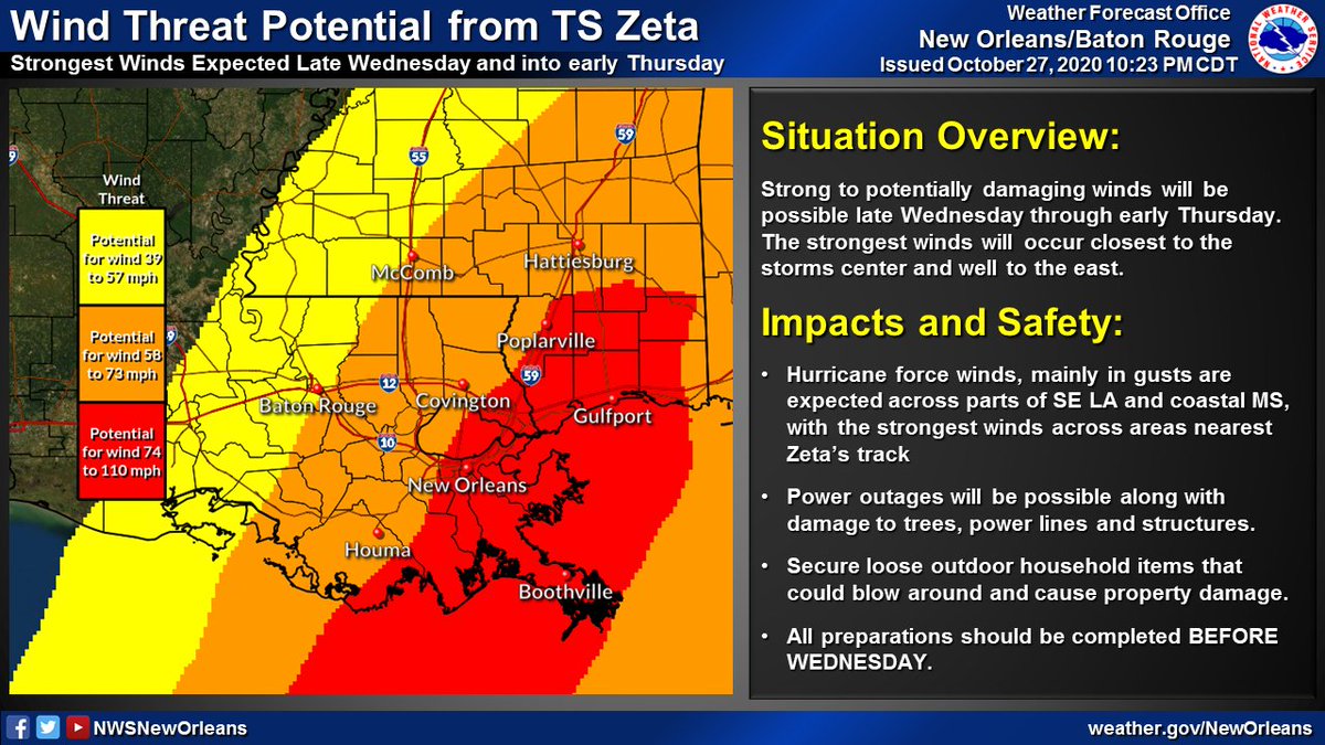
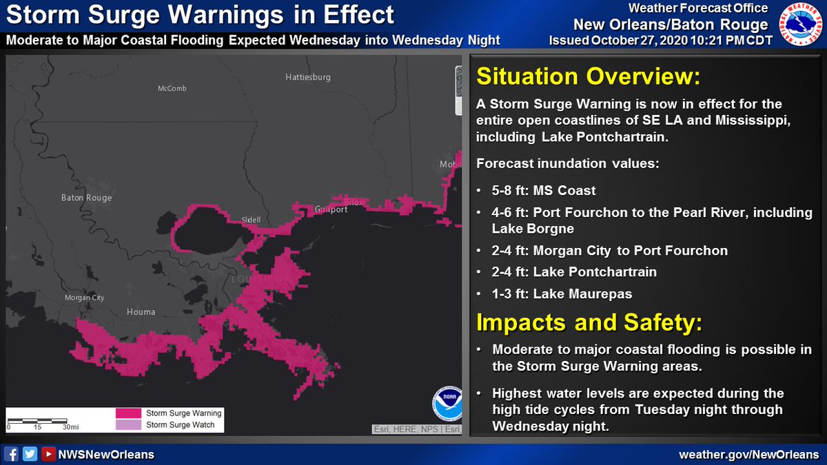
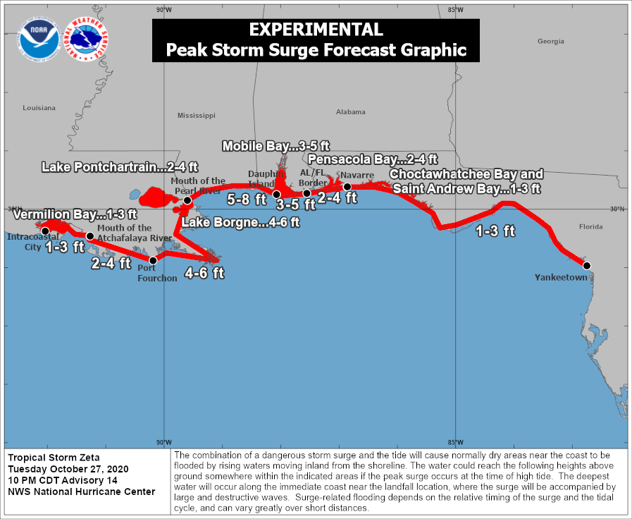
🌀10PM CDT Update on Tropical Storm #Zeta. Starting to see some steady strengthening trend now with max winds at 70mph. Impacts across parts of SE LA and southern MS remain likely on Wednesday.
Lets break down each specific threat one at a time...(1/6)
Lets break down each specific threat one at a time...(1/6)

(1/6) 🌀 7PM CDT Update on Hurricane #Zeta. No major changes this evening as #Zeta continues towards the NW with an eventual, brief landfall expected across the Yucatan later tonight. We are still anticipating impacts, some major across the area Wed & Thu. Stay tuned! #lawx #mswx 

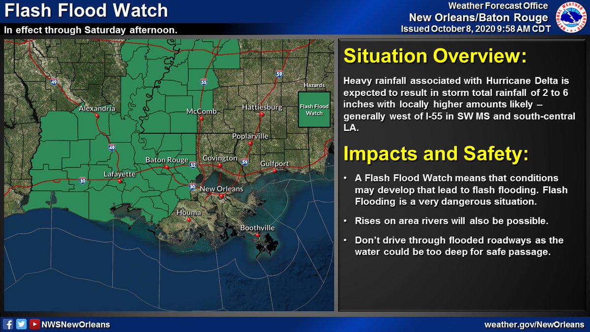
🌀 (1/5): Here's the latest with Hurricane #Delta as of 10AM CDT. Some slight strengthening was noted by recent aircraft recon observations with a steady strengthening trend now expected through the day today. Impacts still remain likely across our area Friday. #lawx #mswx 


Here is the 4AM update on Hurricane #Delta along with a thread on the latest local hazards expected from Hurricane #Delta.
Delta will bring potential for:
🌊Life-threatening storm surge flooding
🌬️Damaging winds
⛈️Heavy rain and flash flooding
#lawx #mswx
(1/5)
Delta will bring potential for:
🌊Life-threatening storm surge flooding
🌬️Damaging winds
⛈️Heavy rain and flash flooding
#lawx #mswx
(1/5)

Here's a thread on the latest local hazards expected from Hurricane #Delta.
Delta will bring potential for:
🌊 Life-threatening storm surge flooding
🌬️ Damaging winds
🌧️ Heavy rain and flash flooding
#lawx #mswx
(1/5)
Delta will bring potential for:
🌊 Life-threatening storm surge flooding
🌬️ Damaging winds
🌧️ Heavy rain and flash flooding
#lawx #mswx
(1/5)

🌀 (1/6): Tweet thread with the latest on Hurricane #Delta. The 10AM position has #Delta continuing to cross the Yucatan & will emerge into the Gulf later today. No major changes to the forecast track as impacts, some significant, may be likely later this week/weekend #lawx #mswx 

🌀 (1/3) 10AM CDT Update on TS #Delta: Delta is now a major hurricane in the west-central Caribbean. No major changes to the forecast track as impacts remain likely along the northern Gulf coast late this week and this weekend. #lawx #mswx 

🌀 (2/3) As a reminder, NOW is the time to have a plan! Don't let the recent cool temperatures fool you - it is still Hurricane Season! Impacts remain likely with this system across portions of the northern Gulf coast and you should take it seriously! #lawx #mswx 


🌀 (3/3) Do you know which NWS office serves your area? Our neighbors include @NWSLakeCharles to our west including SW LA, @NWSJacksonMS to the north across most of MS, & @NWSMobile to our E including the AL/FL beaches. Follow your local office for the latest updates! #lawx #mswx 

Things are picking up in Lake Charles, as evidenced by a huge gust hitting Stephanie Abrams during her live shot on The Weather Channel #HurricaneLaura #LAwx
And here was another huge gust that almost knocked Stephanie Abrams down #HurricaneLaura #LAwx
You can tell the eyewall is coming into Lake Charles as both Stephanie Abrams and Jim Cantore are having quite the time staying upright #HurricaneLaura #LAwx
Here's a thread with the latest on Hurricane #Laura. It continues to strengthen as it moves toward the NW Gulf Coast. Minor to moderate impacts are expected across portions of SE LA and S MS. #lawx #mswx (1/5) 

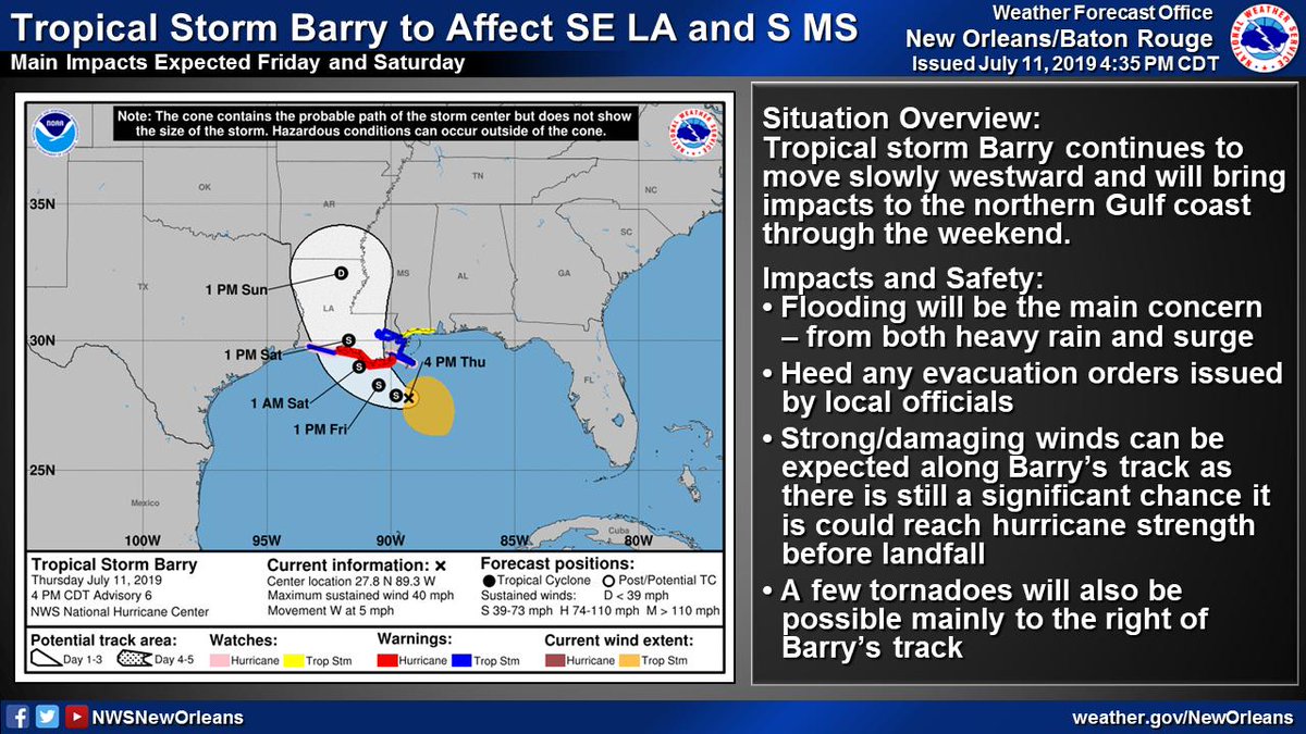
(1/6) 5:15p Thu TS #Barry Update
🌧️🌊Flooding continues to be the greatest threat - both from heavy rain and storm surge
🌬️Strong/Damaging winds possible along Barry's track as it could still become a hurricane
🌪️A few tornadoes possible, especially near the coast
#lawx #mswx
🌧️🌊Flooding continues to be the greatest threat - both from heavy rain and storm surge
🌬️Strong/Damaging winds possible along Barry's track as it could still become a hurricane
🌪️A few tornadoes possible, especially near the coast
#lawx #mswx
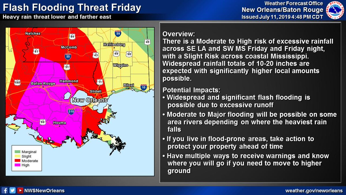
(2/6) Significant flood threat associated w/ #Barry
📏10-20" of rain with significantly higher local amounts possible
⏰Heaviest rain expected Friday through Saturday night
🌧️Heavy rain could lead to widespread/life-threatening flash flooding and moderate to major river flooding
📏10-20" of rain with significantly higher local amounts possible
⏰Heaviest rain expected Friday through Saturday night
🌧️Heavy rain could lead to widespread/life-threatening flash flooding and moderate to major river flooding
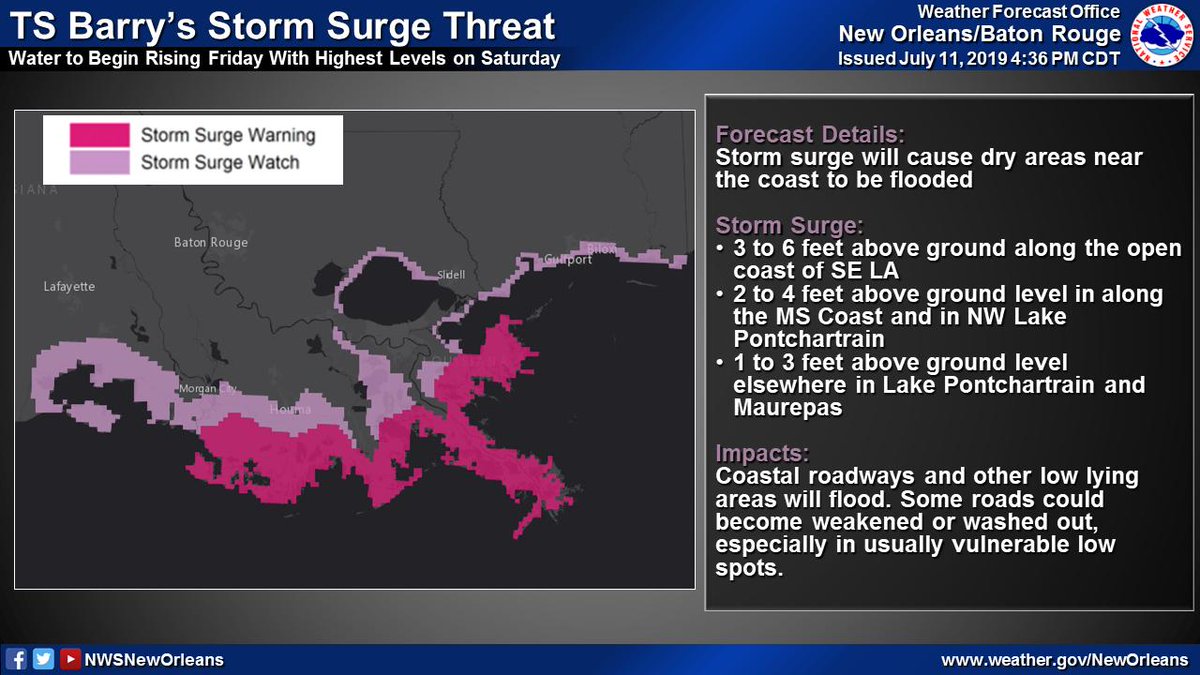
(3/6) TS #Barry will result in a storm surge threat across SE LA and coastal MS
📏3-6 ft of inundation possible along open coast of SE LA
⏰Water levels begin rising Friday with highest levels on Saturday
🌊Storm surge will flood coastal roadways and other low lying areas
📏3-6 ft of inundation possible along open coast of SE LA
⏰Water levels begin rising Friday with highest levels on Saturday
🌊Storm surge will flood coastal roadways and other low lying areas
