Discover and read the best of Twitter Threads about #HungaTongaHungaHaapai
Most recents (8)
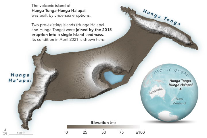
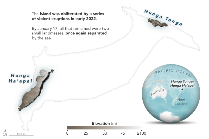
A mapping effort led by @NASAGoddard's chief scientist shows how the explosive volcanic eruption at #Tonga's #HungaTongaHungaHaapai obliterated the island. go.nasa.gov/3rE8jo4 


“This is a preliminary estimate, but we think the amount of energy released by the eruption was equivalent to somewhere between 4 to 18 megatons of TNT,” said Jim Garvin. 🌋
For comparison, scientists estimate Mount St. Helens exploded in 1980 with 24 megatons and Krakatoa burst in 1883 with 200 megatons of energy. go.nasa.gov/3tRKk7t 

🌋 #HungaTonga 💥 Desde el sábado se esta hablando mucho de este volcán, pero...¿os gustaría conocer más sobre esta erupción? Arrancamos hilo desde el #IGNSpain sobre la erupción del #HungaTongaHungaHaapai
(👇 sigue para verlo 😉)
(👇 sigue para verlo 😉)
#HungaTongaHungaHaapai es una erupción ocurrida el 15 de enero en Tonga (pacífico sur) que ha afectado a 3 islas muy jóvenes: Hunga Tonga, Hunga Ha’Apai y una isla nueva que se había formado en medio de ambas. Las tres formaban el borde norte de una caldera de un volcán submarino 

La última erupción comenzó el 21 de diciembre de 2021 y el 4 de enero ya había descendido mucho su actividad. Las columnas eruptivas habían llegado a más de 16 km de altura, cayendo ceniza en las dos islas y otras adyacentes.
📹 Créditos de Taaniela Kula en Youtube
📹 Créditos de Taaniela Kula en Youtube
#Nomuka #Tonga via Sentinel-1 #satellite, before and after the #HungaTongaHungaHaapai volcano eruption.
This island south of Nomuka looks to have been inundated, based on Sentinel-1 radar image (darker areas = water).
Using a new feature of @sentinel_hub here's a sequence of SAR radar before/Sentinel-2 true color before/and then SAR radar after where you can see where the reflectivity of the land has changed to water.
#Tonga 🇹🇴🌋
Resumen de actividad 🧵👇
El volcán #HungaTongaHungaHaapai se encuentra a 67km al noroeste de la capital #Nukualofa, es parte de una caldera submarina dentro del arco volcánico de Tonga-Kermadec que se extiende desde desde #NuevaZelanda hasta a #Fiji.


Resumen de actividad 🧵👇
El volcán #HungaTongaHungaHaapai se encuentra a 67km al noroeste de la capital #Nukualofa, es parte de una caldera submarina dentro del arco volcánico de Tonga-Kermadec que se extiende desde desde #NuevaZelanda hasta a #Fiji.


Hasta finales del 2014, inicios del 2015 en esta zona del Océano Pacífico existían dos islas (#HungaTonga y #HungaHaapai), las cuales se unieron después de una serie de erupciones masivas. 


Incredible satellite footage of the volcanic eruption in #Tonga ..
#Tsunami alert going on currently as well and footage showing it’s already started hitting some islands.. crazy🤯
Mother Nature is undefeated 🌊💨
#Tsunami alert going on currently as well and footage showing it’s already started hitting some islands.. crazy🤯
Mother Nature is undefeated 🌊💨
Praying for everyone being affected by this..
Cannot imagine seeing this with my own eyes.
*not my footage*
#Volcano #Tonga #HungaTonga #HungaTongaHungaHaapai #underwater #Tsunami #Tonga #Oceania #MotherNature
Cannot imagine seeing this with my own eyes.
*not my footage*
#Volcano #Tonga #HungaTonga #HungaTongaHungaHaapai #underwater #Tsunami #Tonga #Oceania #MotherNature
The first #stratospheric #volcanic #eruption of 2022, at #HungaTongaHungaHaapai (#Tonga) on Jan 13-14. #Sentinel5P #TROPOMI & @NASA's Aura/OMI both measure ~0.05 Tg SO₂ in the #volcanic cloud - not enough for #climate impacts. @CopernicusEU @NASAEarth @volcanessa @MetService 


Another spectacular #eruption of Hunga #Tonga-Hunga Ha'apai at ~04:00 UTC on Jan 15. #Himawari8 data via @CIRA_CSU.
First look at SO₂ in the Jan 15 #eruption cloud measured by @eumetsat MetOp/GOME-2. So far, the SO₂ columns do not appear to be extreme; generally <20 Dobson Units (DU). For a Pinatubo-scale event we'd expect SO₂ columns >100 DU. More data soon.
Source: sacs.aeronomie.be/nrt
Source: sacs.aeronomie.be/nrt

#Tonga 🌋🇹🇴
Nube de hongo sobre el volcán #HungaTongaHungaHaapai durante la erupcion de ayer.
Analicemos cómo se forman estas curiosas nubes. 🧵👇
Nube de hongo sobre el volcán #HungaTongaHungaHaapai durante la erupcion de ayer.
Analicemos cómo se forman estas curiosas nubes. 🧵👇

Big eruption from Hunga Tonga-Hunga Ha'apai. Lots of ice. Some SO2. Ash difficult to detect with the usual methods. Cloud-top temperatures reaching 182 K (-91°C), likely stratospheric (>16.5 km asl). #HungaTongaHungaHaapai #HungaTonga


