Discover and read the best of Twitter Threads about #HungaTonga
Most recents (12)
The eruption is over but the ground is still shaking - there have been dozens of #earthquakes around the #HungaTonga #volcano (magnitude 4.5-5), continuing today. 1/3
#GoogleEarth #Tonga #earthquake
#GoogleEarth #Tonga #earthquake

Many are likely due to slip on existing faults or fracturing of new ones due to changes in crustal stress caused by the eruption. Others may be linked to magma movement, although that usually produces a more persistent signal called #volcanictremor. 2/3
volcano.oregonstate.edu/volcano-sounds…
volcano.oregonstate.edu/volcano-sounds…
I haven't seen any focal mechanisms for these events, which would tell us more about the type of #earthquake - it may be difficult to extract that information as these events are M5 or less, and seismic networks are sparse in this region. 3/3
Explosiva erupción de Volcán🌋#HungaTonga en Enero15 generó onda en Atmósfera, cuyo frente fue capturado por GOES-16🛰viajando de Oeste a Este sobre Sudamerica (hay q mirar con atención)👇
⚠️¿A qué rapidez viajaba ese frente de onda? ~1100 km/h, más rápido q un jet✈️comercial!
⚠️¿A qué rapidez viajaba ese frente de onda? ~1100 km/h, más rápido q un jet✈️comercial!
Hay varias maneras de estimar la rapidez, pero nosotros lo hicimos analizando la huella que el frente de onda dejó en las lecturas de presión de las estaciones meteorológicas alrededor del mundo👇 

Más allá de la rapidez de la onda, estamos pendientes de potenciales efectos en la temperatura global. Las estimaciones actuales indican q, a pesar de espectacularidad, las emisiones de #SO2 originadas en esta erupción particular no son suficientes para afectar el clima global👇
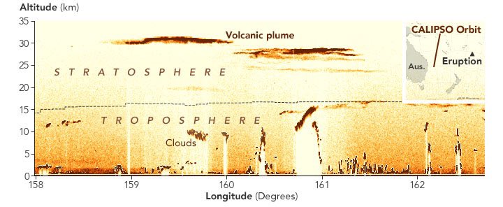
Pluma resultante de explosiva erupción de Volcán🌋#HungaTonga en Enero15 logró alcanzar >39km de altitud convirtiéndose en la más alta registrada por CALIPSO🛰
⚠️#SO2 inyectado en estratósfera no sería suficiente para afectar considerablemente ClimaGlobal.earthobservatory.nasa.gov/images/149347/…

⚠️#SO2 inyectado en estratósfera no sería suficiente para afectar considerablemente ClimaGlobal.earthobservatory.nasa.gov/images/149347/…


El efecto en el clima global de las erupciones volcánicas en general depende de la cantidad #SO2 inyectado en la atmósfera
Cuando #SO2 alcanza la estratósfera (parte alta de atmósfera) puede mantenerse en suspensión durante meses y alcanzar los polos. Está por lo tanto por verse cual será el efecto de esta erupción en la temporada del #AgujeroDeOzono (q comienza en Agosto)👇
🌋 #HungaTonga 💥 Desde el sábado se esta hablando mucho de este volcán, pero...¿os gustaría conocer más sobre esta erupción? Arrancamos hilo desde el #IGNSpain sobre la erupción del #HungaTongaHungaHaapai
(👇 sigue para verlo 😉)
(👇 sigue para verlo 😉)
#HungaTongaHungaHaapai es una erupción ocurrida el 15 de enero en Tonga (pacífico sur) que ha afectado a 3 islas muy jóvenes: Hunga Tonga, Hunga Ha’Apai y una isla nueva que se había formado en medio de ambas. Las tres formaban el borde norte de una caldera de un volcán submarino 

La última erupción comenzó el 21 de diciembre de 2021 y el 4 de enero ya había descendido mucho su actividad. Las columnas eruptivas habían llegado a más de 16 km de altura, cayendo ceniza en las dos islas y otras adyacentes.
📹 Créditos de Taaniela Kula en Youtube
📹 Créditos de Taaniela Kula en Youtube
Thick black clouds of ash, lightning, and toxic gases choked the skies as the underwater #HungaTonga volcano violently erupted over the weekend… the largest recorded eruption in over 30 years.
(1/8)
(1/8)
The blast triggered a tsunami and sent a visible shock wave around the world.
The plume of toxic gas and ash shot 12 miles into the air with a 161+ mile radius, according to @NOAA.
(2/8)
The plume of toxic gas and ash shot 12 miles into the air with a 161+ mile radius, according to @NOAA.
(2/8)
Here you can see the ash and large amounts of sulfur dioxide (SO2) injected into the atmosphere.
(3/8)
(3/8)
Height of #HungaTonga eruption looks to have been around 30 km, from space-based lidar. CREDIT: Ozone Mapping and Profiler Suite (OMPS) data on NASA site via Dr Ghassan Taha. ozoneaq.gsfc.nasa.gov/data/aerosols/… science.gsfc.nasa.gov/sed/bio/ghassa… 

Note: The 2014 Kelud eruption observed on lidar showed comprehensively that if you get the lidar over the right spot, you can see very high tops! 30 km is prob not the actual top. Nor did we see how high the much larger Pinabuto eruption really went. volcano.si.edu/volcano.cfm?vn…
Important to NOT rush to height comparisons of eruptions from different eras of observation or to derive VEIs. In particular ground and space-based observations often don't correlate (see sciencedirect.com/science/articl…), and space-based obs are getting better as time marches on
1/ Early indications point to #HungaTonga eruption being comparable in size to the largest eruption in the last century: Mt. Pinatubo in Philippines.
If this is in fact the case, it is likely to have major implications for climate, weather, and markets in coming years.
A 🧵...
If this is in fact the case, it is likely to have major implications for climate, weather, and markets in coming years.
A 🧵...
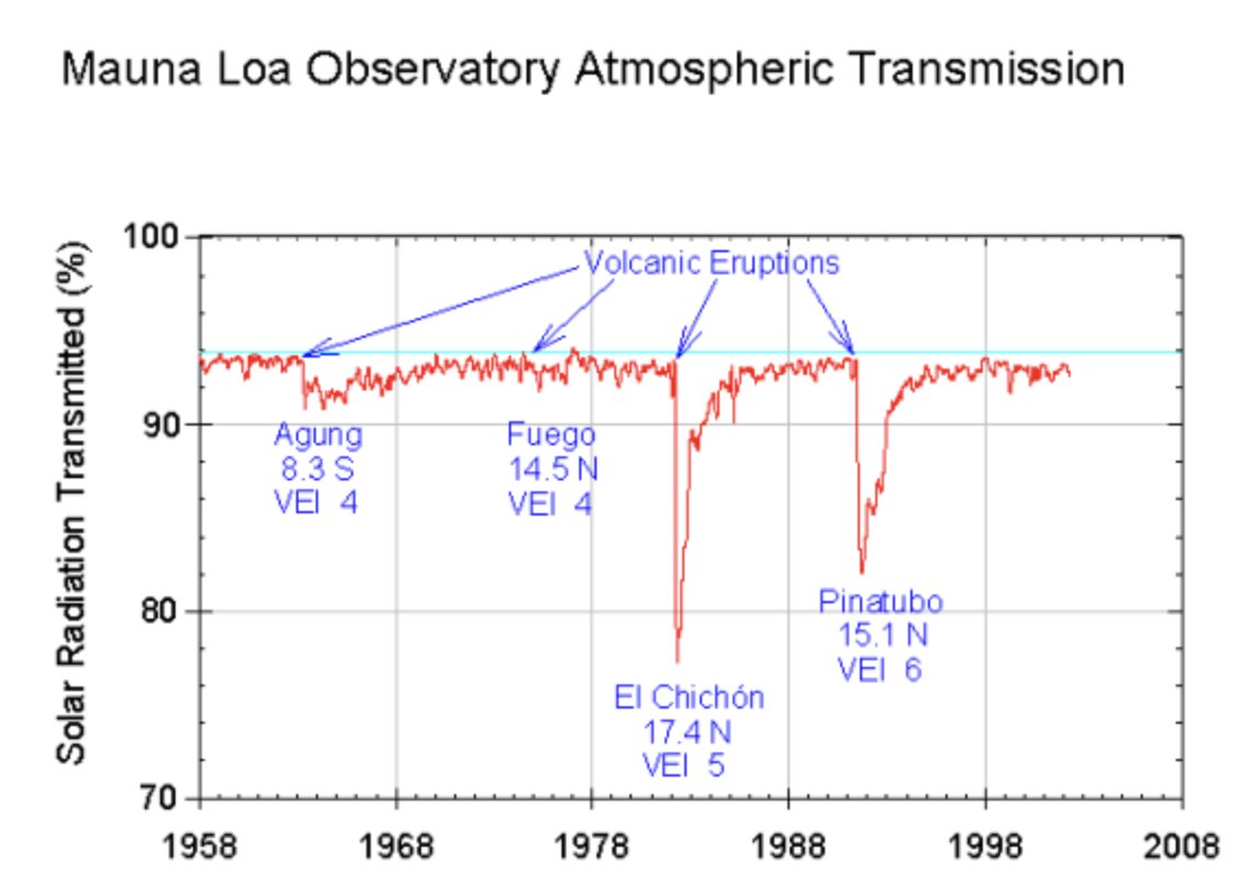
2/ Leaning on data collected after the Pinatubo eruption in 1991 as the closest modern proxy, we can make some make some reasonable predictions on what impact #HungaTonga may have:
The huge amount of reflective ash released from Pinatubo caused significant global cooling:
The huge amount of reflective ash released from Pinatubo caused significant global cooling:

A quick 🧵 about the *size* of the #HungaTonga eruption:
Volcanic eruptions are generally assigned a VEI—Volcanic Explosivity Index—value.
This scale is a general indicator of the explosive character of an eruptive event.
1/
Volcanic eruptions are generally assigned a VEI—Volcanic Explosivity Index—value.
This scale is a general indicator of the explosive character of an eruptive event.
1/
This scale, described by Christopher Newhall and Stephen Self in a 1982 paper, is a general indicator of the explosive character of an eruptive event, and reflects the interplay of an eruption's magnitude, intensity, and energy release rate.
2/
2/
The VEI rating scale employs a set of criteria including ejecta volume, style of eruption, plume height, and injection of gases into the troposphere and stratosphere.
There's no question that the #Tongaeruption was huge—it absolutely was.
3/
There's no question that the #Tongaeruption was huge—it absolutely was.
3/
#Tonga 🇹🇴🌋
Resumen de actividad 🧵👇
El volcán #HungaTongaHungaHaapai se encuentra a 67km al noroeste de la capital #Nukualofa, es parte de una caldera submarina dentro del arco volcánico de Tonga-Kermadec que se extiende desde desde #NuevaZelanda hasta a #Fiji.


Resumen de actividad 🧵👇
El volcán #HungaTongaHungaHaapai se encuentra a 67km al noroeste de la capital #Nukualofa, es parte de una caldera submarina dentro del arco volcánico de Tonga-Kermadec que se extiende desde desde #NuevaZelanda hasta a #Fiji.


Hasta finales del 2014, inicios del 2015 en esta zona del Océano Pacífico existían dos islas (#HungaTonga y #HungaHaapai), las cuales se unieron después de una serie de erupciones masivas. 


Incredible satellite footage of the volcanic eruption in #Tonga ..
#Tsunami alert going on currently as well and footage showing it’s already started hitting some islands.. crazy🤯
Mother Nature is undefeated 🌊💨
#Tsunami alert going on currently as well and footage showing it’s already started hitting some islands.. crazy🤯
Mother Nature is undefeated 🌊💨
Praying for everyone being affected by this..
Cannot imagine seeing this with my own eyes.
*not my footage*
#Volcano #Tonga #HungaTonga #HungaTongaHungaHaapai #underwater #Tsunami #Tonga #Oceania #MotherNature
Cannot imagine seeing this with my own eyes.
*not my footage*
#Volcano #Tonga #HungaTonga #HungaTongaHungaHaapai #underwater #Tsunami #Tonga #Oceania #MotherNature
Big eruption from Hunga Tonga-Hunga Ha'apai. Lots of ice. Some SO2. Ash difficult to detect with the usual methods. Cloud-top temperatures reaching 182 K (-91°C), likely stratospheric (>16.5 km asl). #HungaTongaHungaHaapai #HungaTonga


