Discover and read the best of Twitter Threads about #GISsurfer
Most recents (14)
1/ If you are looking at any of the interactive #GISsurfer wildland fire maps I have posted, here is a thread that will help you use the map. #DixieFire #FrenchFire #CaldorFire #McFarlandFire #MonumentFire #SchneiderSpringsFire
2/ To search on an address click Menu > Search.
To change the basemap, click the button next to the “Menu” button. Basemaps I usually use are:
USA basemap
ESRI scanned topo USA
Open street map
To change the basemap, click the button next to the “Menu” button. Basemaps I usually use are:
USA basemap
ESRI scanned topo USA
Open street map
3/ To turn on geolocation tap Menu > My location.
A symbol will appear and follow you as you move.
Tap that symbol to see your coordinates and accuracy value.
A symbol will appear and follow you as you move.
Tap that symbol to see your coordinates and accuracy value.
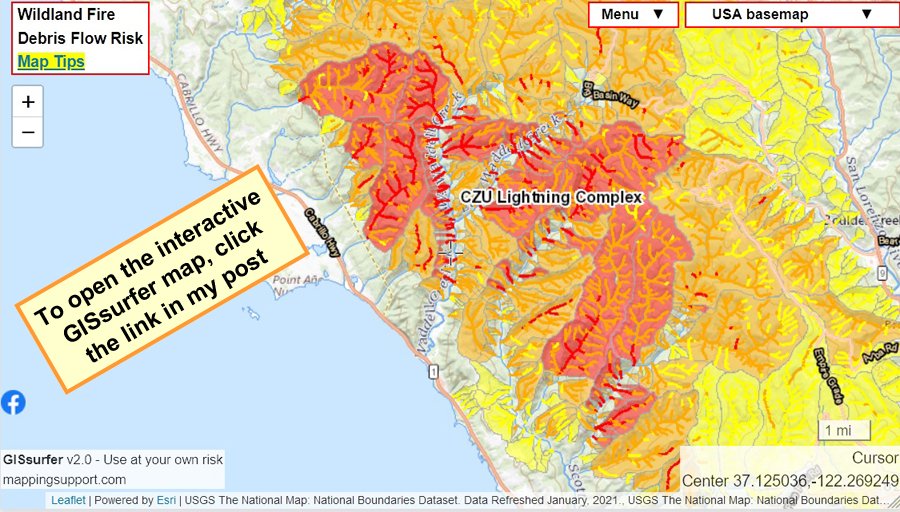
1/_ Interactive #GIS map showing risk of #DebisFlow for wildland fires. For the legend and to get the most benefit from the map, please click “Map tips” in upper left corner. To search on address click Menu > Search. #CAwx
Open #GISsurfer map: bit.ly/39Y5BRA
Open #GISsurfer map: bit.ly/39Y5BRA

2/_ The map opens at the #CZULightningComplex. You can pan the map to other 2020 fires and see the same type of data. Be patient! The map might be slow to refresh. It depends in part on how much other work the GIS server is doing.
3/_ The map can display the risk of debris flow for fires back to 2017. Here is one way to make a map to see the risk of debris flow for a fire prior to 2020:
A. Click the basemap button and look under the “Overlays” heading
B. Click “Turn off all overlays”
A. Click the basemap button and look under the “Overlays” heading
B. Click “Turn off all overlays”
1/6 I’ve been volunteering to produce online wildland fire maps for about the last 10 years. The #1 thing to know is that any fire data you see on maps is **not real time**. There are 2 MODIS satellites and 2 VIIRS satellites. #GlassFire #GlassIncident #ZoggFire
2/6 The MODIS/VIIRS satellites make a total of 8 passes per 24 hours. For the West Coast very rough timing is midnight to 3am (4 passes) and noon to 3pm (4 passes). It takes NASA ~3 hours to process the raw data before it can be displayed on any map.
3/6 Usually by 7am pacific time the maps are showing all the MODIS/VIIRS data that is available until sometime after 3pm. Hotspot locations are approximate and sometimes the data is ‘false positive’.
1/3 Sunday 9/6 #CreekFire 45,532 acres per infrared flight 10pm yesterday + analysis by fire staff. VIIRS satellite hotspot data (orange squares) *might* be ‘false positives’. Hope everyone got out. See 2 links upper left corner.
Open #GISsurfer map: bit.ly/330xqoF
Open #GISsurfer map: bit.ly/330xqoF

2/3 False positive satellite hotspot data can happen when (1) there is a large fire throwing hot embers up in the smoke plume and (2) the satellite sees the fire at a sharp angle instead of more straight down.
3/3 The fire perimeter on the map is a goofy blue line instead of red/black. I will fix that. It would sure be nice if the teams that collect/analyze the infrared data would use a standard file layout for their results.
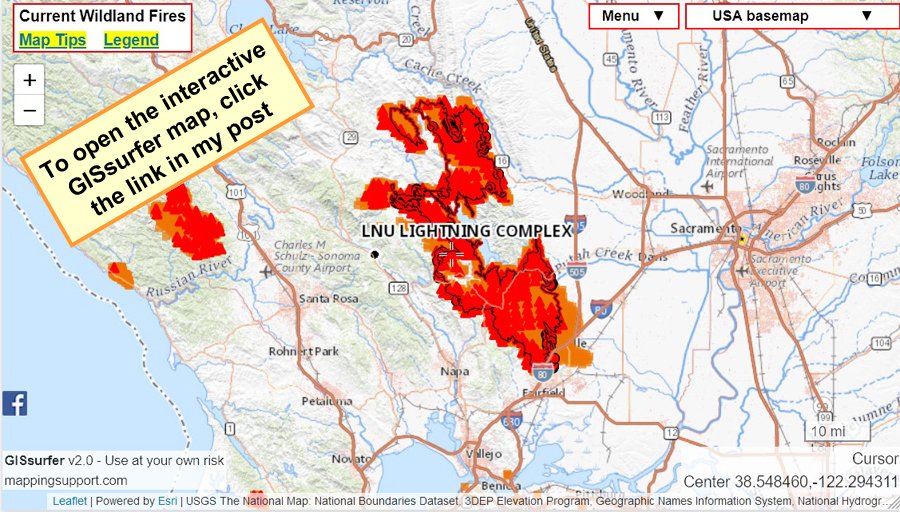
1/3 Thursday 8/20 #HennesseyFire 190,078 acres per infrared flight yesterday + analysis by fire staff. The other #LNULightningComplex fires (#GambleFire, #GreenFire & #MarkleyFire) have merged into Hennessey.
Open #GISsurfer map: bit.ly/32aMzTT
Open #GISsurfer map: bit.ly/32aMzTT

2/3 Map has lots of #GIS overlays you can turn on/off/restack. Need help? Click "Map tips" upper left corner. There is also a ‘Legend’ link in the upper left corner.
3/3 Note! The map is still showing some ‘false positive’ satellite hotspots. That problem should fix itself mid-morning. For more information, click “Map tips” and read about the data.
1/3 Wednesday Aug 19 8:30am. The satellite hotspot data for #HennesseyFire and other area fires is showing many ‘false positive’ hotspots. Lake Berryessa is not on fire. Likewise, the #HennesseyFire has not crossed I-80.
2/3 False positive satellite hotspots can happen when (1) the satellite ‘sees’ the fire near the edge of the strip of land the satellite examines and (2) the fire is throwing a huge amount of smoke loaded with hot/burning embers.
3/3 But with all that said, keep the #1 rule firmly in mind. If you are told to evacuate then get your butt in gear and GO! (Map is wrong! Be sure to read my 2 earlier posts in this thread)
Open #GISsurfer map: bit.ly/2CGlz6d
Open #GISsurfer map: bit.ly/2CGlz6d

1/4 If you zoom out any of the fire maps I post then you will always see all the current satellite hotspot data. That data is automatically updated several times per day. MODIS = red triangle. VIIRS = orange square.
Open #GISsurfer map: bit.ly/3h8oKCF
Open #GISsurfer map: bit.ly/3h8oKCF

2/4 Caution! Satellite hotspot data is *always* several hours old when you see it on a map and locations are approximate. Never rely on any map to ignore an order to evacuate!
3/4 To make your own custom map link, zoom in on an area or click Menu ==> Search. Turn on the overlay layers you want. Then click Menu ==> Link to this map. The link you see will replicate the map on your screen.
1/4 Are COVID-19 cases/deaths increasing or decreasing over the last 14 or last 7 days in your county or state? This interactive map uses authoritative data from Johns Hopkins to give you the answer. Need help? Click “Map tips”.
Open #GISsurfer map: bit.ly/2Vr25Jk
Open #GISsurfer map: bit.ly/2Vr25Jk

2/4 Each location on the map has two symbols. Circle = prior 14 days. Triangle = prior 7 days. Red = count is trending up. Green = count is trending down.
3/4 The map has several COVID-19 overlays you can turn on/off. When the map opens the overlay “County bad trend in deaths” is ‘on’. Each symbol is a county where the number of deaths over the prior 7 days is trending up.
1/4 Are you a #bored #student or #teacher? Do you like #maps #geography #GIS? Consider taking a look at #GISsurfer which is a general purpose web map I developed. This project is a public service and part of my way to “pay it forward”.
Homepage: gissurfer.com
Homepage: gissurfer.com

1/7 Curated list of 3,500+ government #ArcGIS server addresses. All links tested once per week and bad links fixed or flagged. These are ArcGIS servers, not 'portals'.
#URISA #fedGIS #GIS #GISP #GeoSpatial #ESRI #MAPPS @GISLounge @directionsmag
Open PDF:
mappingsupport.com/p/surf_gis/lis…
#URISA #fedGIS #GIS #GISP #GeoSpatial #ESRI #MAPPS @GISLounge @directionsmag
Open PDF:
mappingsupport.com/p/surf_gis/lis…

2/7 @server Admins: If my list says “not https” or “SSL problem” then you can fix that with a free SSL certificate from letsencrypt.org. My domains use these. The “SSL problem” tag in the curated server list means Firefox found something wrong with your SSL certificate.
3/7 To find data quickly on an ArcGIS try a Google advanced search. For example, to find trail layers search on:
trails site:____
Replace the underline with an ArcGIS server address.
trails site:____
Replace the underline with an ArcGIS server address.
1/4
Anyone can make their own custom #GISsurfer map to see near real time wind data.
1. Open GISsurfer with no layers bit.ly/2pfeMtq.
2. Drag and zoom to your area of interest. Or do Menu ==> Search
#DiabloWind #DiabloWinds #KincadeFire #TickFire
Anyone can make their own custom #GISsurfer map to see near real time wind data.
1. Open GISsurfer with no layers bit.ly/2pfeMtq.
2. Drag and zoom to your area of interest. Or do Menu ==> Search
#DiabloWind #DiabloWinds #KincadeFire #TickFire
2/4
3. Turn on one of the wind gust or wind speed layers. Click the basemap button (next to “Menu” button), look under “Overlay” heading (mobile users scroll down), click layer to turn it on/off.
4. To stay oriented, turn on: ESRI roads and labels, County, State boundary.
3. Turn on one of the wind gust or wind speed layers. Click the basemap button (next to “Menu” button), look under “Overlay” heading (mobile users scroll down), click layer to turn it on/off.
4. To stay oriented, turn on: ESRI roads and labels, County, State boundary.
3/4
5. Turn on: NOAA weather observations. Zoom out if you do not see any red stars.
6. Click Menu ==> Link to this map.
That link will replicate the map on your screen
5. Turn on: NOAA weather observations. Zoom out if you do not see any red stars.
6. Click Menu ==> Link to this map.
That link will replicate the map on your screen
1/3 NASA broke the #GISsurfer fire map I have posted. The MODIS/VIIRS hotspot data the map displays is frozen since NASA is not updating the KML data files that I copy and host on my server. Grrrr. @NASA #KincadeFire #TickFire
2/3 Naturally happens late Friday before a major weekend wind event. I reported using the NASA FIRMS support form and got an auto reply from someone saying they are out of the office until Wednesday. I did find an email that got my report in their system so now we wait.....
3/3 Other fire maps that can directly access NASA’s WMS server will display the correct data. However, that server has a ‘rate limit’ that is easily exceeded by the high demand for my map. That is why I copy and host the data on my own server.
1/4 Why is perimeter data on the #Inciweb fire map out-of-date? The Inciweb map simply displays perimeter data that is hosted on the GeoMAC #GIS server. Why doesn’t the GeoMAC server have current perimeter data? #WAfire #ORfire #CAfire #AZfire #COfire #MTfire #GeoSpatial
2/4 For most big fires there usually is a nighttime overflight with infrared sensing gear. Experts analyze that data and determine a new fire perimeter. They also determine areas of intense, scattered and isolated heat. That data is then hosted on the public NIFC FTP server.
3/4 That new fire perimeter eventually shows up on the GeoMAC server and will then appear on the Inciweb map. The problem is that it seems to take a day or more for that perimeter data to go from the NIFC server to the GeoMAC server. Surely that process could be speeded up.
Interactive map shows warning for #tornado (red outline) and severe thunderstorm (yellow outline). Map shows latest data from federal #GIS servers. Click “Map tips” upper left corner for more info. Open #GISsurfer map: bit.ly/2Jg582T #SevereWx 

Click inside any of the outlined areas and then follow the link for the details.
Oppsie! I messed up that map link. Here is a corrected link that focuses attention on the actual tornado warnings and severe thunderstorm warnings.
Open #GISsurfer map: bit.ly/2Cku5Eu
Open #GISsurfer map: bit.ly/2Cku5Eu


