Discover and read the best of Twitter Threads about #DixieFire
Most recents (20)
How was PG&E convicted of mass manslaughter in the 2018 #CampFire?
We finally have the case they pleaded guilty to: 42 days of secret testimony in front of a Butte County grand jury.
We've made all 5,000+ pages available, but since you likely haven't got time to read 'em...
We finally have the case they pleaded guilty to: 42 days of secret testimony in front of a Butte County grand jury.
We've made all 5,000+ pages available, but since you likely haven't got time to read 'em...

...here's a link to our story.
And a brief thread on what @ABC10's #FirePowerMoney team found inside 👇
Dozens of PG&E employees testified under oath.
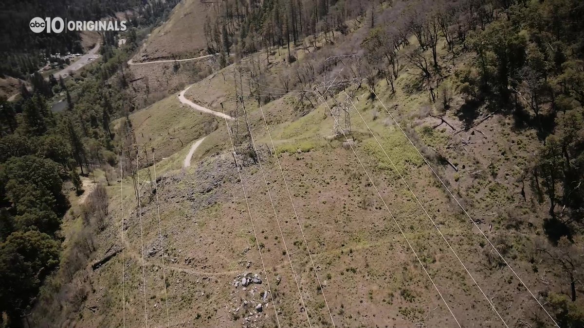
Prosecutors started with what they found at the origin point of the Camp Fire:
abc10.com/article/news/l…
And a brief thread on what @ABC10's #FirePowerMoney team found inside 👇
Dozens of PG&E employees testified under oath.
Prosecutors started with what they found at the origin point of the Camp Fire:
abc10.com/article/news/l…
Enfin une « bonne » nouvelle en provenance des États-Unis 🇺🇸 : La #sécheresse en partie résorbée en #Californie après plusieurs épisodes d’#intempéries ces dernières semaines. L’État de l'Ouest #américain était en proie à une sécheresse historique à l’automne dernier. #Thread 🧵 

📈Contexte : Les #USA contigus ont connu un été météorologique (Juin-Août) 2021 record 🌡, l’un des plus chaud jamais enregistré, à égalité avec l’été 1936. Sur la période Janvier-Août 2021, les températures sur tout l’ouest américain ont été bien au-dessus des normales. @NOAA 


Zoom 🔎 sur l’Ouest américain : Tout simplement l’été météorologique le plus chaud depuis le début des relevés en 1895. Près de 3°C au-dessus de la normale 🥵 (1901-2000). Du jamais vu !
Source : @NOAA

Source : @NOAA


🍔DISCOUNTS & FREEBIES FOR #DIXIEFIRE & #CALDORFIRE EVACUEES🍔
Here is a thread of places offering discounts and freebies for you during this trying time. New offerings will be added ASAP. Call ahead to verify, as needed! Please RT.
Here is a thread of places offering discounts and freebies for you during this trying time. New offerings will be added ASAP. Call ahead to verify, as needed! Please RT.

🍽️FREE LUNCH & DINNER🍽️ for #DixieFire & #CaldorFire evacuees and survivors at FISH in #CarsonCity, NV. No questions asked! They serve it daily from 11:30 AM-5 PM. 775-882-FISH (3474) nvfish.com 

👧BOYS & GIRLS CLUB PLACERVILLE CLUBHOUSE👧is free for #CaldorFire & #DixieFire evacuee kids - you don't have to be a member! Kids get breakfast, lunch and snacks, too. 530-295-8019, 2840 Mallard Dr, #Placerville. bgce.org 

MEDIA: I know you are distracted by new shiny things but the #DixieFire is still burning. More evacuations yesterday. More homes and structures are being lost. A lot of resentment is circulating amongst evacuees and survivors. Don’t forget them. Because they will remember this.
And this mainly refers to Northern California media. No one cares from national media anymore and I don't expect them too with the Caldor situation. Except maybe industry news.
Before anyone says "Why aren't you reporting on it?" - I've never been to the Dixie Fire area and I only due intensive fire coverage on Napa/Sonoma/Solano/Mendo/Lake/Marin/Yolo. Self-imposed coverage area. *I am* relaying evacuee and donation information for Dixie Fire, however.
💵#DIXIEFIRE & #CALDORFIRE DONATION LIST💵
Here are ways you can donate to help survivors & evacuees. Remember, cash is always preferred! This list will be updated regularly. Thank you for your donations! 👇
Here are ways you can donate to help survivors & evacuees. Remember, cash is always preferred! This list will be updated regularly. Thank you for your donations! 👇

🐻GOLD COUNTRY WILDLIFE RESCUE🐻
@gcwrescue is helping to rescue, rehabilitate, and release WILD animals impacted by the Caldor Fire. Donate: goldcountrywildliferescue.org/donate/
@gcwrescue is helping to rescue, rehabilitate, and release WILD animals impacted by the Caldor Fire. Donate: goldcountrywildliferescue.org/donate/

⛑️RED CROSS OF NORTHERN NEVADA⛑️
has volunteers operating shelters in Reno and Gardnerville. Donate: redcross.org/donate/donatio… (select disaster relief).


has volunteers operating shelters in Reno and Gardnerville. Donate: redcross.org/donate/donatio… (select disaster relief).



🙋VOLUNTEERS NEEDED🙋 #DixieFire #CaldorFire
Here is a list of volunteer opportunities to help evacuees, survivors, and animals impacted by these fires. New opportunities will be posted.👇
Here is a list of volunteer opportunities to help evacuees, survivors, and animals impacted by these fires. New opportunities will be posted.👇

⛑️RED CROSS OF NORTHERN NEVADA⛑️
Needs volunteers to help provide relief and support to evacuees at the many evacuation centers in the region. Apply online or contact lacey.costanza@redcross.org or call (775) 225-3392. redcross.org/local/nevada/v…
Needs volunteers to help provide relief and support to evacuees at the many evacuation centers in the region. Apply online or contact lacey.costanza@redcross.org or call (775) 225-3392. redcross.org/local/nevada/v…
💜CATHOLIC CHARITIES OF NORTHERN NEVADA💜
Needs volunteers to help with resource distribution. You do not have to be Catholic! You must be vaccinated. Learn more ccsnn.org/pages/volunteer or call Lisa at lzross@ccsnn.org or (775) 322-7073, ext. 235.
Needs volunteers to help with resource distribution. You do not have to be Catholic! You must be vaccinated. Learn more ccsnn.org/pages/volunteer or call Lisa at lzross@ccsnn.org or (775) 322-7073, ext. 235.
🌎🔥 Early this month the @IPCC_CH report stated: "Climate change widespread, rapid, and intensifying"
From Siberia to the Amazon, see where fires raged on Earth August 2021 🧵⬇️
#ClimateEmergency #ExtremeWeather #heatwave
📹 #Caldorfire via @SPACEdotcom
From Siberia to the Amazon, see where fires raged on Earth August 2021 🧵⬇️
#ClimateEmergency #ExtremeWeather #heatwave
📹 #Caldorfire via @SPACEdotcom
🇬🇷 Aug 3 - Greece
100+ forest fires in 24hrs, thousands evacuated.
– "We are no longer talking about climate change but about a climate threat"
[This is the fire thread: the Earth on fire August 2021 🧵⬇️]
#ClimateEmergency #ExtremeWeather #heatwave
cnn.com/2021/08/09/eur…
100+ forest fires in 24hrs, thousands evacuated.
– "We are no longer talking about climate change but about a climate threat"
[This is the fire thread: the Earth on fire August 2021 🧵⬇️]
#ClimateEmergency #ExtremeWeather #heatwave
cnn.com/2021/08/09/eur…
🇺🇸 Aug 4 - US #RiverFire
[This is the fire thread: the Earth on fire August 2021 🧵⬇️]
#ClimateEmergency #ExtremeWeather #heatwave
capradio.org/articles/2021/…
[This is the fire thread: the Earth on fire August 2021 🧵⬇️]
#ClimateEmergency #ExtremeWeather #heatwave
capradio.org/articles/2021/…
Yesterday's #Washingtonfire in Tuolumne County was an excellent reminder of why size is a poor metric for fires. It was only 81 acres, not enough to even need a 209 report. But bc of where it started, 8 homes were lost, pets and livestock were killed. It was a disaster. 1/5
You might think "oh, it's only 8 homes." But these were all primary homes, not cabin/vacation homes. Since we scientists like to normalize when we compare things, you could even argue that at 1 home/10 ac, it has the highest area-weighted losses (0.1 h/ac) of 2021 so far. 2/5
By contrast, the mammoth #DixieFire is closing in on 750K ac and has burned ~1,200 structures. Even if 1,000 are homes (a high estimate), that's 1 home/750ac (0.0013h/ac) area-weighted. Which fire is worse? It's an absurd question -> both are disasters to those affected. 3/5
1/ If you are looking at any of the interactive #GISsurfer wildland fire maps I have posted, here is a thread that will help you use the map. #DixieFire #FrenchFire #CaldorFire #McFarlandFire #MonumentFire #SchneiderSpringsFire
2/ To search on an address click Menu > Search.
To change the basemap, click the button next to the “Menu” button. Basemaps I usually use are:
USA basemap
ESRI scanned topo USA
Open street map
To change the basemap, click the button next to the “Menu” button. Basemaps I usually use are:
USA basemap
ESRI scanned topo USA
Open street map
3/ To turn on geolocation tap Menu > My location.
A symbol will appear and follow you as you move.
Tap that symbol to see your coordinates and accuracy value.
A symbol will appear and follow you as you move.
Tap that symbol to see your coordinates and accuracy value.
The original tweet was mine @buriedbybooks and I corrected the wording of that tweet and apologized as noted below
The #DixieFire is still being investigated but it is unclear yet as to what happened
PG&E has come forward to provide information and details.
It is still under investigation.
PG&E has come forward to provide information and details.
It is still under investigation.

Une ligne électrique exploitée par PG&E semble, encore une fois, être à l'origine du #DixieFire - qui est maintenant l'#incendie le plus grave de l'histoire de la Californie.
Le risque était connu et la ligne devait être enterrée prévenir un départ de feu.
latimes.com/california/sto…
Le risque était connu et la ligne devait être enterrée prévenir un départ de feu.
latimes.com/california/sto…
En 2018, c'est déjà un incident sur une ligne aérienne de PG&E qui était à l'origine du Camp Fire : 620km² brulés dont la petite ville de Paradise, 85 morts.
Incapable de faire face à ses responsabilités PG&E s'était déclaré en faillite.
wsj.com/articles/pg-e-…
Incapable de faire face à ses responsabilités PG&E s'était déclaré en faillite.
wsj.com/articles/pg-e-…
Les faillites américaines ne sont souvent qu'un refuge temporaire contre les créanciers : PG&E sort de ce statut en juin 2020 sans changement notoire dans son activité ou sa gouvernance.
Juste quelques engagements, notamment sur la modernisation du réseau.
latimes.com/environment/st…
Juste quelques engagements, notamment sur la modernisation du réseau.
latimes.com/environment/st…
NEW: @PGE4Me's federal probation judge, William Alsup, demands answers on the #DixieFire and #FlyFire.
He asks about the tree that fell on PG&E's power line at the Dixie origin point-- demands inspection images showing what it looked like before it fell.
#FirePowerMoney @ABC10

He asks about the tree that fell on PG&E's power line at the Dixie origin point-- demands inspection images showing what it looked like before it fell.
#FirePowerMoney @ABC10


This judge found PG&E committed safety violations in the 2020 #ZoggFire, which killed four people.
He based that finding in part on 2019 inspection photos of the power line, showing the tree leaning in the power line's direction.
#FirePowerMoney @ABC10
abc10.com/article/news/c…
He based that finding in part on 2019 inspection photos of the power line, showing the tree leaning in the power line's direction.
#FirePowerMoney @ABC10
abc10.com/article/news/c…
The #DixieFire is just the latest in a long list of criminal investigations (also convictions) against PG&E for causing big disasters:
#FirePowerMoney @ABC10 #CampFire #KincadeFire #SanBruno #ZoggFire
abc10.com/article/news/l…
#FirePowerMoney @ABC10 #CampFire #KincadeFire #SanBruno #ZoggFire
abc10.com/article/news/l…
Horrific situation in Northern California... The #DixieFire has ballooned into California's 6th largest fire on record. 6 of the state's 7 biggest fires on record have occurred since last August! wapo.st/3lxXEtw by @HazardWriter (1/x)
#DixieFire off Above the Cresta Dam, Feather River Canyon in Butte County is 278,227 acres and 35% contained. Unified Command: @CALFIRE_ButteCo and @LassenNF
fire.ca.gov/incidents/2021…


fire.ca.gov/incidents/2021…



#DixieFire off Above the Cresta Dam, Feather River Canyon in Butte County is 274,139 acres and 35% contained. Unified Command: @CALFIRE_ButteCo and @LassenNF
fire.ca.gov/incidents/2021…


fire.ca.gov/incidents/2021…


#DixieFire off Above the Cresta Dam, Feather River Canyon in Butte County is 254,466 acres and 35% contained. Unified Command: @CALFIRE_ButteCo and @LassenNF
fire.ca.gov/incidents/2021…


fire.ca.gov/incidents/2021…


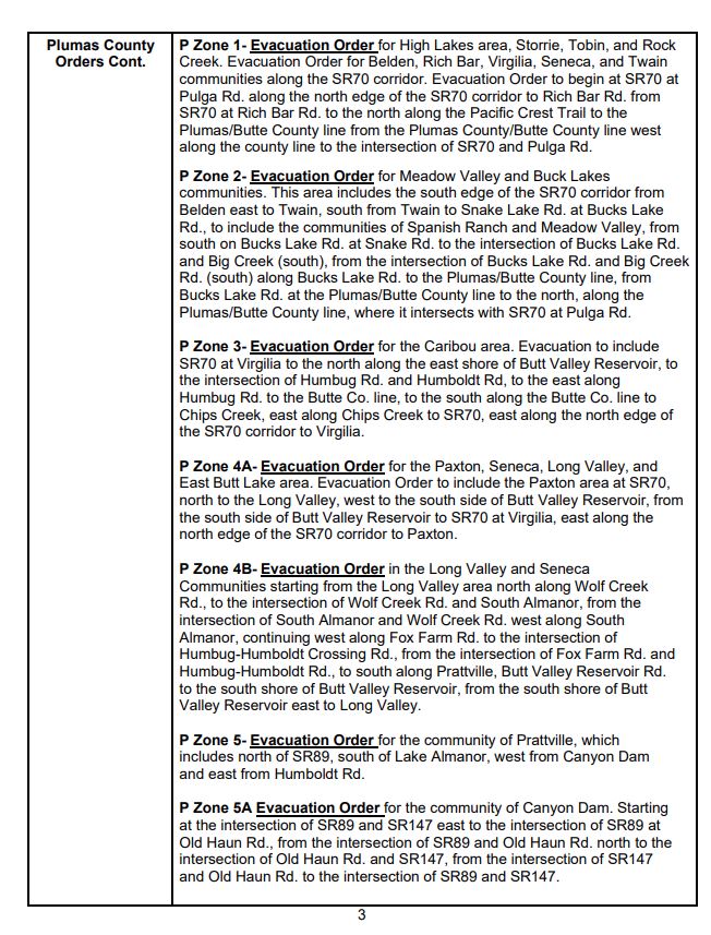

#DixieFire Cont. 


#DixieFire Cont. 


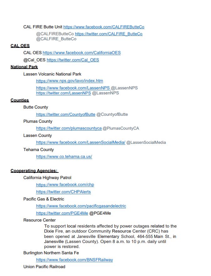

In less than 10 days, the #DixieFire destroyed eight structures, spurred thousands of evacuations, and grew into the largest wildfire in California this year.
Here's how it became the state's biggest of the year latimes.com/california/sto…
Here's how it became the state's biggest of the year latimes.com/california/sto…
Earlier this week, it swelled over the Nevada state line for the first time, and on Thursday afternoon, it ignited a 2,500-acre spot fire near Highway 395 that is still growing
latimes.com/california/sto…
latimes.com/california/sto…
As of Saturday, the multicounty fire had swelled to more than 181,000 acres and 18% containment.
Cal Fire deputy incident Cmdr. Chris Waters said the Dixie fire is unlike anything he has experienced in more than two decades of fighting fires latimes.com/california/sto…
Cal Fire deputy incident Cmdr. Chris Waters said the Dixie fire is unlike anything he has experienced in more than two decades of fighting fires latimes.com/california/sto…

It looks to me like a big spot fire just popped up right outside East Quincy, CA from the #DixieFire within the last 1-2 hours. Very close to the town. Called Dixie command and they seemed unaware of any fire near Quincy. Keeping my eye on it. 

Plumas County Sheriff's office hung up on me because they're so busy dealing with this. I'd say keep your eye on their Facebook page for evac orders coming through. I'll reach back out if and when things settle down for more information. #FlyFire
A look at the #DixieFire this morning from the Bloomer Lookout camera, west of Berry Creek. 

Plumas sheriff has just posted on its Facebook page that there is confirmed structure loss in Feather River Canyon. They are working to get numbers and locations.
#DixieFire
#DixieFire
BREAKING: PG&E says some of its equipment may have contributed to the start of the #DixieFire - which has burned thousands of acres and prompted evacuations near the site of the 2018 Camp Fire, the deadliest in California history. @KQEDnews
In a preliminary report filed with state utility regulators - PGE says early on the morning the fire started, a dam it operates on the Feather River lost power. PG&E says a worker saw - from a distance - what he thought was a blown fuse on a nearby power line.
PG&E says the worker wasn't able to get to the scene until nearly 10 hours later because a bridge on the road to the line was out of service. When he got there he saw that two fuses had been blown, that a tree was leaning on the line and that a fire was burning near the tree.

