Discover and read the best of Twitter Threads about #CAFire
Most recents (24)
Lot of attention today focused on SW flank of #MosquitoFire near Foresthill, but eastern flank is also very active today. With upcoming period of SW winds--perhaps getting pretty strong over weekend--there is *possibility* it could run upslope toward Tahoe Basin. #CAwx #CAfire
.@wildland_zko & others have been thoughtfully considering this possibility for some days. With today's resurgence in activity, plus upcoming weather (SW winds, perhaps strong this wknd), & given now record dryness of heavy (100-1000hr) fuels, this is within realm of possibility.
Source for that "record dryness" claim: here's the 1000hr fuel moisture chart for the Northern Sierra PSA as of today. 100hr FM, 1000hr FM, and ERCs all at record levels for date and essentially tied with all-time, any date records. #CAfire 

The coming week is shaping up to be a pretty crazy weather week in California, TBH--even more so than previously thought. Ongoing heatwave expected to be longer & peak even higher, & now we have potential influence of a soon-to develop hurricane to consider. (1/n) #CAwx #CAfire 

First, exceptional daytime & nighttime heat (plus high humidity) continues across SoCal today. Some places may see all-time record warmest overnight temps today. In northern California, much drier heat is building,& temperatures will continue to rise further for days. (2/n) #CAwx
New research on dry lightning events in California, led by @wx_statman, and including co-authors @climate_guy, @NickyNaus, @Weather_West, @danielletouma, & @ClimateChirper, is out today in @IOPenvironment (open access!). #CAwx #CAfire (1/n) iopscience.iop.org/article/10.108…
We assess regional-scale atmospheric conditions favorable for dry lightning in central & northern California (N&C CA), as well as seasonality. We find that nearly half of all lightning strikes in N&C CA are "dry" (accompanied by <0.10 in. of rain). (2/n) iopscience.iop.org/article/10.108… 

In some locations, including most of the San Francisco Bay Area, North Coast, and portions of Southern Sierra, fully 60-80% of May-Oct cloud-to-ground lightning strikes occur as dry lightning! Major implications for wildfire risk. (3/n) #CAwx #CAfire iopscience.iop.org/article/10.108… 

Much of CA & NV has had a fairly mild start to summer--especially in the northern third of state, which even received some late-season precip and some locally below average temperatures over the past month or so. Well, that's all about to change across the interior... #CAwx 

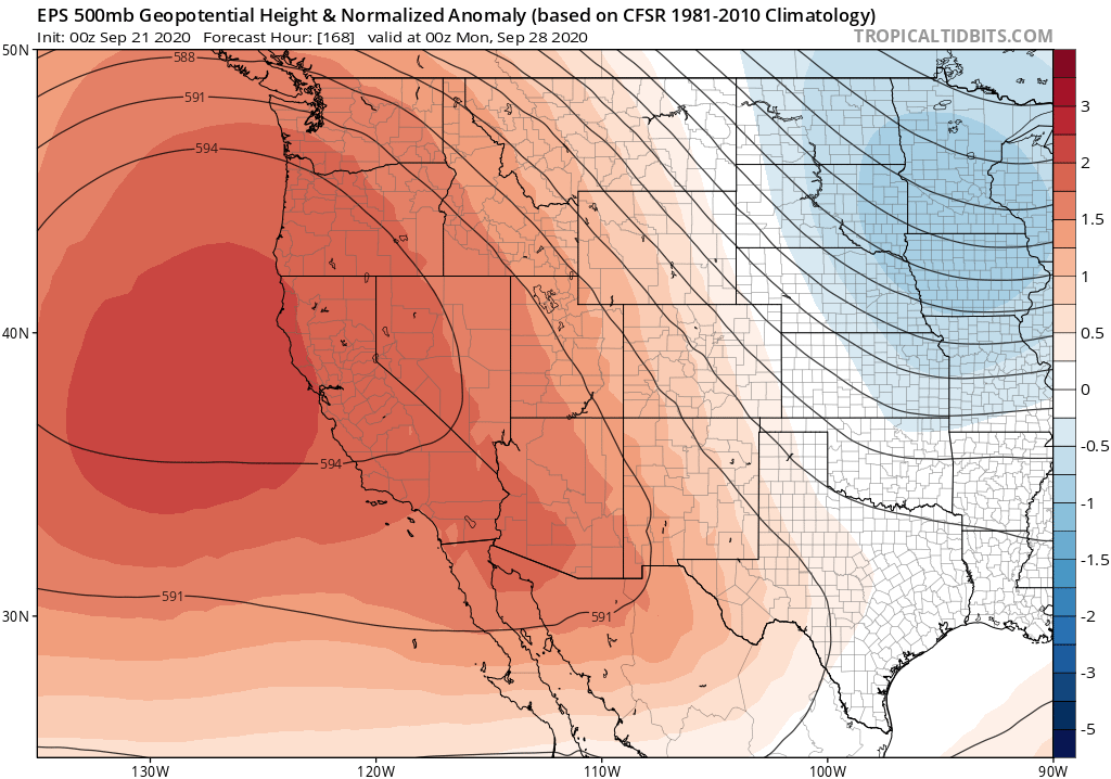
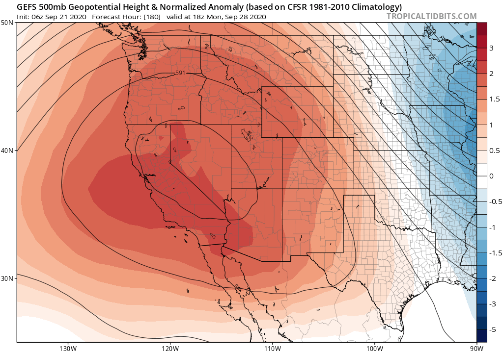
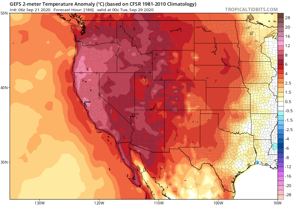
A huge ridge of high pressure will expand westward from its current position near center of continent (where it has been bringing record heat to Texas). This will bring an extremely broad region of hotter than usual temperatures to the entire western 2/3 of the country. #CAwx
While a persistent Four Corners ridge, plus hot temps, are typical for mid summer--this ridge will be significantly broader & stronger than usual even for mid-late July. By late July, much hotter than usual temperatures could extend from Pacific Coast to Great Plains! #CAwx 

This was, by any quantitative measure, an extraordinary (and meteorologically extreme) lightning event across the southern half of California. But the societal impacts will be nowhere as severe as the dry lightning event in August 2020? Why? A brief thread: #CAwx #CAfire
First, & most importantly, the June 2022 thunderstorms were generally significantly wetter than the Aug 2020. Yesterday, most of these cells brought at least brief rains (and sometimes downpours). There were certainly dry strikes outside of rain cores, but most strikes were wet.
The June 2020, by contrast, were truly dry thunderstorms--many places only saw a trace of rainfall or nothing at all. Even a modest amount of rain co-occurring with lightning can greatly reduce (though not eliminate) the likelihood of a lightning-caused wildfire ignition.
California, on statewide basis, is now experiencing its worst drought in observational record going back to late 1800s--narrowly beating out peak of last drought in 2014-15 (as measured by PDSI, a metric that takes into account both precip & temperature). #CAwx #CAfire #CAwater 

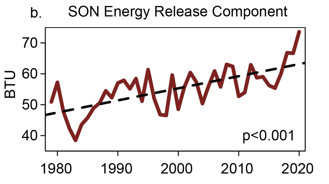
There is a clear trend toward increasing aridity in California--and yet little trend in mean precipitation. How can this be? A very strong warming trend due to #ClimateChange means same the amount of water falling from sky just doesn't go as far as it used to. #CAwx #CAwater 


We explored this phenomena in research published in 2015 (finding that rising temps are the main factor behind increasing CA drought severity):
pnas.org/content/112/13…
and 2018 (increasing "precip whiplash" despite little change in mean):
nature.com/articles/s4155…
#CAwater #CAwx
pnas.org/content/112/13…
and 2018 (increasing "precip whiplash" despite little change in mean):
nature.com/articles/s4155…
#CAwater #CAwx
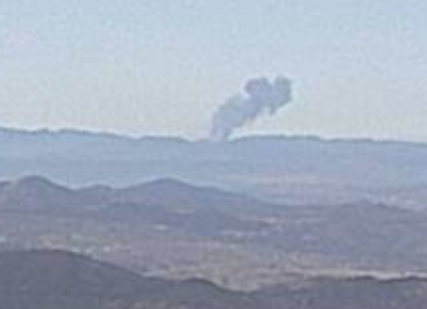
I've got a column of smoke showing from the Idylwild 1 fire camera, it's distant and could be structure fire. Looking south of the mountain toward Temecula. Probably RRU, anyone know whats up?
Looking at the camera angle and ridge it's on, looks to be west of I15, could be on the Pendleton Marine Base. Reaching out to local contacts for further into. Does appear to be a wildfire, however #CAFire. alertwildfire.org/inlandempire/i… 
Watched an incredible scene last night @SanBernardinoNF — Jeffery pine split in two by lightning strike & trunk fire. Thanks to @R5_Fire_News folks for keeping it from spreading! #CAfire
Here is a series of photos from 5pm yesterday to 9am this morning as the Jeffery pine burned — it was a gorgeous 200+ year old healthy tree that had an unlucky day @SanBernardinoNF #CAfire 


This strike happened just across the street from the Big Bear Lake airport — we saw the flash & heard it hit from the house we were staying in 1/4 mile away — incredible. Full details from @SanBernardinoNF here:
Dry lightning event of *some* magnitude is now looking increasingly likely across *some portions* of CA on Sun/Mon. Details to come. But first, some thoughts on potential wildfire risks posed if this comes to fruition. (Thread) #CAwx #CAfire 

Usually, fewer than 1 in 10 lightning strikes actually ignites a wildland fire. These numbers can be higher if lightning is not accompanied by precip, or if lightning occurs under unusually dry conditions in dense vegetation. But in general, lightning ignition *rate* is low-ish.
A big problem thus arises when there are a very large number of dry lightning strikes. This occurred during the extraordinary and historic Aug 2020 event in Northern CA, where 10,000+ strikes were observed (and subsequently *hundreds* of fires were ignited).
Correction to give more accurate context: vegetation dryness & flammability metrics (1000hr fuel moisture & ERC, respectively) are indeed exceeding record levels for *calendar* date over most of Sierra Nevada, but *not* records for *any date.* (Phew!) (1/4) #CAwx #CAfire 

For those interested, the confusion apparently arose due to a differing period of record for NorCal vs. SoCal data via the NorthOps/SouthOps GACCs. In SoCal, period of record is only ~10 years, so "any date" records less meaningful. So: data not wrong, but context is missing.
This really doesn't change the overall picture: there's still an exceptionally severe drought across all of Northern California and vegetation is still exceptionally dry--even relative to extreme values of recent years. But it's important to get the details right! (3/4)
@MichaelWWara @jtemple As I've been emphasizing recently, the *predictable* aspects of Fire Season 2021 (soil moisture/vegetation dryness) are as bad or worse as any observed historically. The level of landscape flammability--especially in denser brush & forests--is genuinely scary. BUT... (1/2)
@MichaelWWara @jtemple ...A big part of what makes certain fire seasons exceptionally severe (from lives lost, homes burned, & ecosystems damaged perspective) has substantial random component. Do ignitions primarily occur during extreme fire wx? Do we see many heatwaves/wind/dry lightning events? (2/3)
@MichaelWWara @jtemple Latter aspects are largely not predictable in advance (except perhaps frequency of heatwaves--which are indeed expected to be elevated). In 2020, we were very unlucky w/all the unpredictable elements. I hope we won't be in 2021...but that's not a good management plan! (3/3)
My perspective piece, "A shorter, sharper rainy season amplifies California wildfire risk," is now out in GRL. I discuss recent findings pointing toward shortening & sharpening wet season, & implications for ecology/wildfire. (1/17) #CAwx #CAfire #CAwater agupubs.onlinelibrary.wiley.com/doi/abs/10.102…
This perspective is in response to a recent analysis led by Jelena Luković showing that seasonal onset of CA precipitation has become progressively delayed (by ~1 month) in recent decades, w/ shorter but sharper rainy season. Underlying paper: agupubs.onlinelibrary.wiley.com/doi/full/10.10… (2)
Record heat, plus late arrival of seasonal rains, have played a key role in CA's extremely severe wildfire seasons in recent years. Autumn 2020 exemplified this trend: vegetation conditions were, by a wide margin, the most flammable on record.#CAfire agupubs.onlinelibrary.wiley.com/doi/abs/10.102… (3) 


First, some good news: NorCal seems to have made through initial (extreme wind) phase of this critical fire weather event relatively unscathed. Few new small fires, but nothing unmanageable. A few thoughts as to why this was the case: #CAwx #CAfire
Very strong to extreme winds and exceptionally low humidity did materialize, despite an initial delay. A peak Bay Area gust of 89mph (with fairly widespread gusts above 50-60 mph), and peak Sierra Nevada gusts well over 100mph, were recorded. #CAwx #CAfire
In some spots, extreme winds did indeed mix down to low elevations (interior North Bay Valleys; Oakland Airport; San Francisco; Half Moon Bay). But some locations closer to sea level saw little wind,so sea level gusts were somewhat less widespread than initially anticipated.#CAwx
Folks: major wind/extreme low humidity/fire weather event is still coming--it just might be slightly delayed (by a couple hours or so in SF Bay Area). Very surprised to hear that PG&E is cancelling some of the planned PSPS with strong winds still inbound?? #CAwx #CAfire
Are @NWSBayArea or @NWSSacramento aware of any major forecast changes that would explain why PG&E is claiming that conditions will no longer justify a PSPS (at least in portions of East Bay Hills and Sierra foothills)? I certainly am not...
cc @RobMayeda @psuweatherman I am genuinely baffled here.
Confidence increases regarding a significant offshore flow event late in the weekend - not just strong winds, but the very dry airmass with it. Comparing offshore gradients SFO-WMC. (1/4)
2017 Wine Country Fires -17.8mb
2019 Kincade -16.3mb
2020 Model Fcst Sunday night -18 -20mb
2017 Wine Country Fires -17.8mb
2019 Kincade -16.3mb
2020 Model Fcst Sunday night -18 -20mb
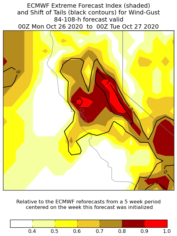
This is the fire weather forecast I was hoping wouldn't come to pass, given all that has already transpired in 2020: Very strong offshore winds, coupled w/exceptionally low humidity & record-dry vegetation, will bring extremely critical wildfire risk Sun/Mon. 1/3 #CAwx #CAfire 

This will likely be strongest & most widespread offshore wind event of season, & is reminiscent of extreme events in 2019 & 2017. Hardest-hit areas appear to be west slopes of Sierra Nevada (gusts of 70+mph) & SF Bay Area (widespread gusts 40-50mph; higher in hills). #CAwx 

Exceptionally low atmospheric humidity (relative humidity of 5% or less and dewpoints below zero F) will accompany these strong winds. This will be a *cold* offshore wind event, and temperatures will drop precipitously (especially in mountains). #CAwx 


New research led by @ggpersad & featuring @PabloWater. Using downscaled climate model simulations, we show that there is unexpectedly high inter-model agreement re: increasing extremity of California hydroclimate due to #ClimateChange. (1/n) link.springer.com/article/10.100… #CAwater
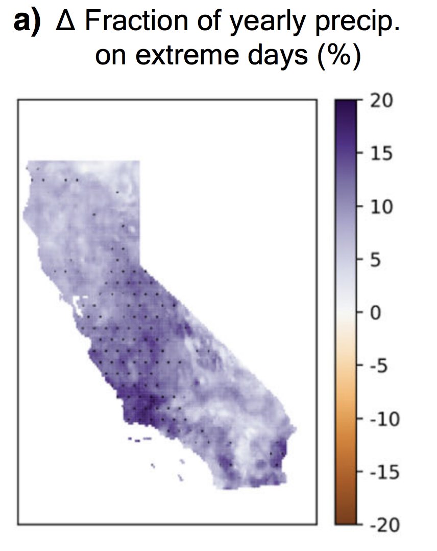
In general, climate models agree than an increasing fraction of California's overall precipitation will become concentrated into the most intense events--and that the most extreme precip events will themselves be substantially more intense. (2/n) link.springer.com/article/10.100… #CAwater 
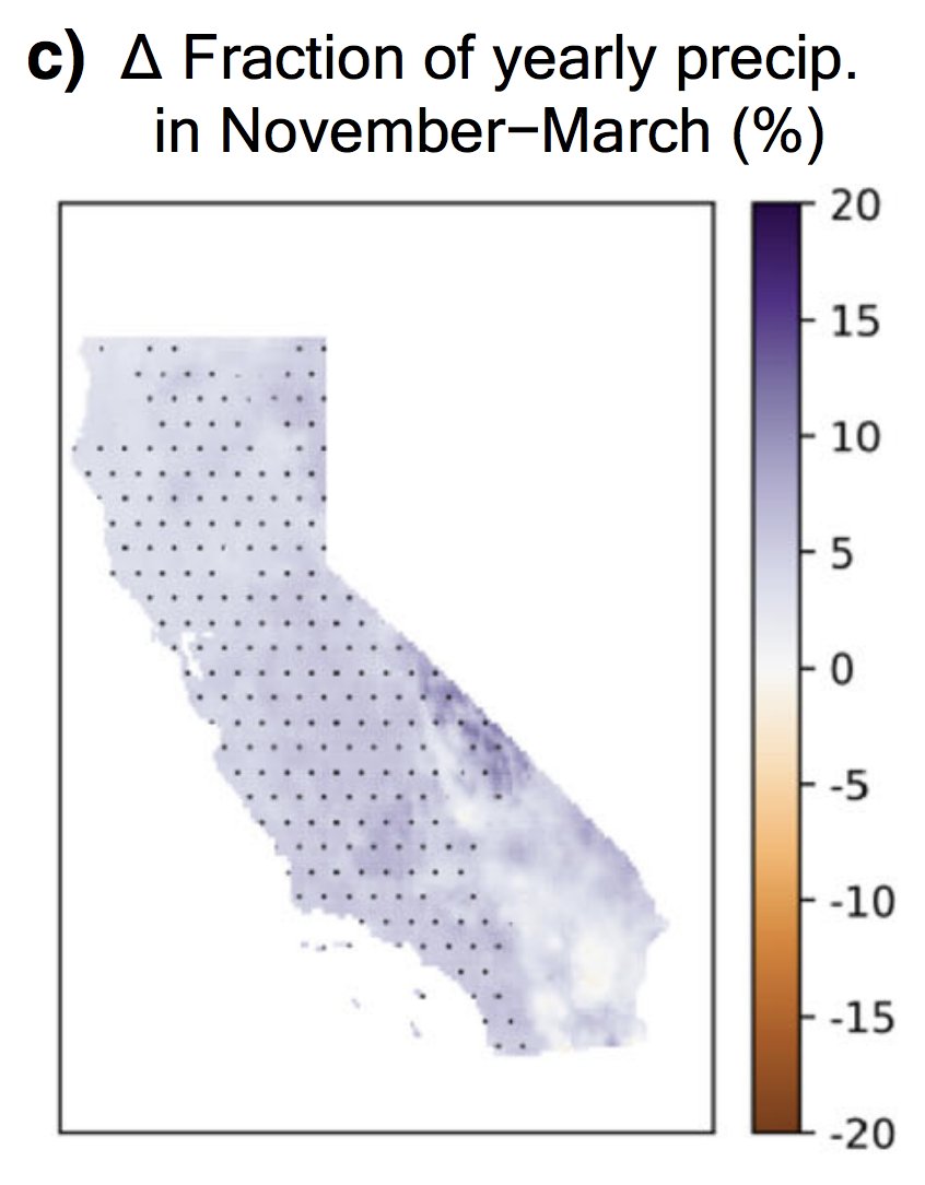
There is also agreement that CA's already pronounced precipitation seasonality will become even sharper--with more rain concentrated into winter months at expense of the autumn & spring. Consider the wildfire season implications... (3/n) link.springer.com/article/10.100… #CAwater #CAfire 
Fire weather update: relatively mild (near avg) temps will continue for a few more days across California. Calmer winds will result in poor air quality, as visible this AM. A weak cold front with a few light North Coast showers possible mid-week. But then... #CAwx #CAfire (1/n) 

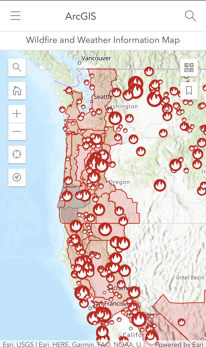
I don’t think people are aware of how much of the west coast is burning right now: #WaWILDFIRE #OregonFires #CAfire arcgis.com/home/webmap/vi… 
While I have you, please take the time to confirm you’re registered to vote: vote.gov
Additional context from replies:
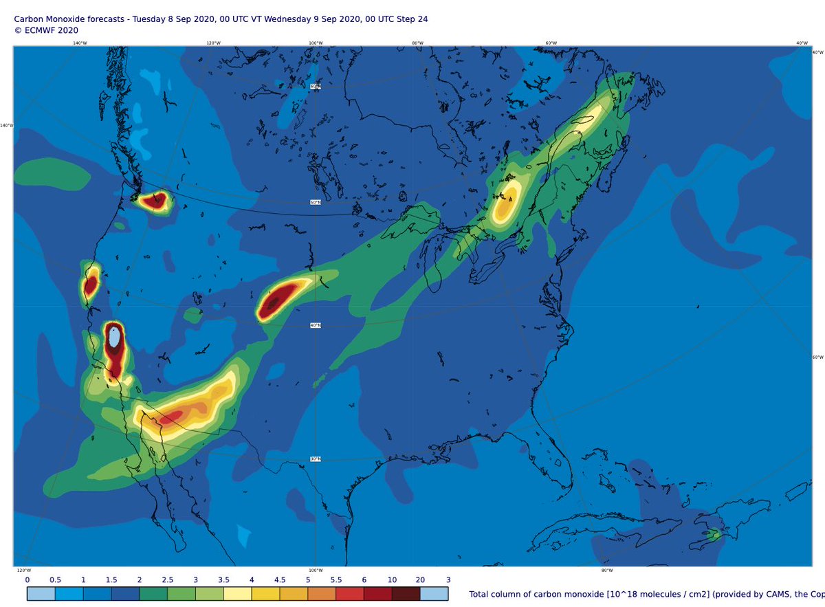
Clear increase in daily total intensity of #CaliforniaFires & #ColoradoFires on 7 Sept >> 2003-2019 mean in #CopernicusAtmosphere GFAS data. Latest 24-hour aerosol & carbon monoxide forecasts show long-range transport of smoke extending across the US from SW to NE. 


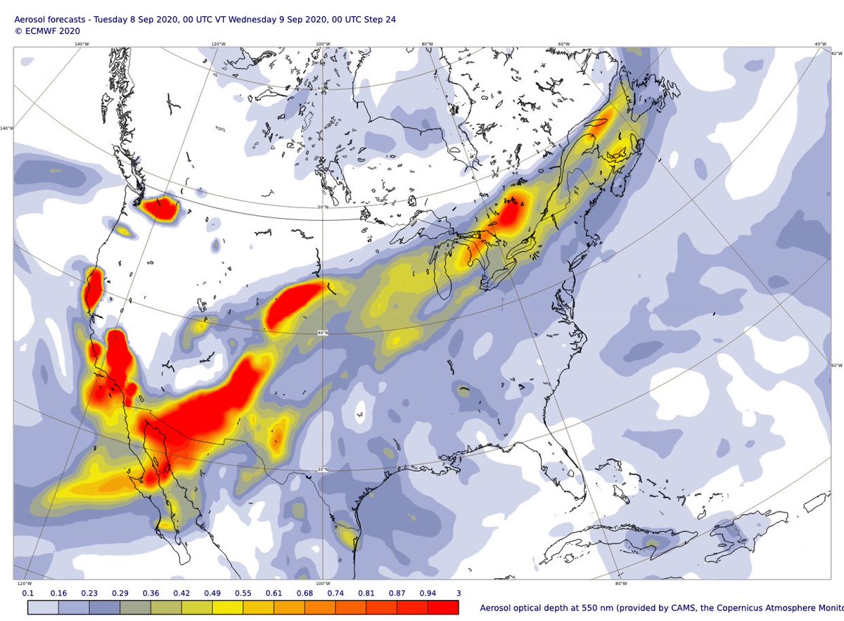
Aerosol forecast charts ➡️ atmosphere.copernicus.eu/charts/cams/ae…
Carbon monoxide forecast charts ➡️ atmosphere.copernicus.eu/charts/cams/ca…
Carbon monoxide forecast charts ➡️ atmosphere.copernicus.eu/charts/cams/ca…
Incredible scale of ongoing #CaliforniaFires with total estimated #wildfire emissions for California to 7 Sept 2020 already state’s highest annual total in 18-year #CopernicusAtmosphere GFAS dataset (Colorado achieved this in August) confluence.ecmwf.int/display/CKB/CA… #CAfire #COfire 


Finally some good news to report: last night's dry lightning event was less widespread & intense than earlier feared. Nearly all lightning spared Bay Area, though there were strikes in Central Valley & western Sierra foothills that may have sparked new fires. (1/3) #CAwx #CAfire 

A few thoughts (thread) on the upcoming lightning event in California. All models are showing the potential for at least isolated mixed wet/dry thunderstorms in central/northern California, which is obviously not good news given the number of fires already ongoing #CAwx #CAfire
The first wave (tonight-Sunday) appears a little weak and with the upper-level ridging in place, storms are going to be near the coast and track more offshore. But the second wave (Sunday night - Monday), breaks down the ridge and strong southerly develops over California #CAwx
Here is the NSSL-WRF forecast composite reflectivity (essentially what the radar may look like) for the next 48 hours. Chance of lightning tonight and Sunday afternoon. But stronger storms and more coverage Sunday night through Monday #CAwx
Okay, time for a NorCal fire weather update. First, good news: fire activity decreased overnight due to development of shallow marine layer along immediate coast, and cooler temps inland. Next 24 hours, fire activity will be strongly diurnal (i.e.,like normal).#CAwx #CAfire (1/n) 
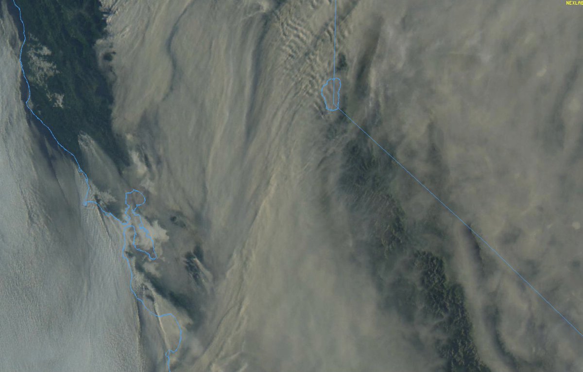
The bad news: this is as good as things are going to get for a while. This wknd, ridge builds back in once again from east, suppressing marine layer and bringing hot/dry conditions inland (though will *not* be as hot as last record heatwave over past week). #CAwx #CAfire (2/n) 
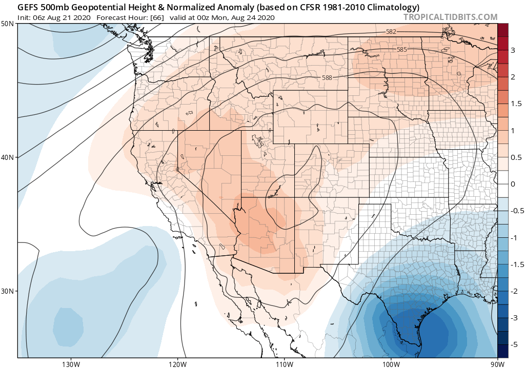
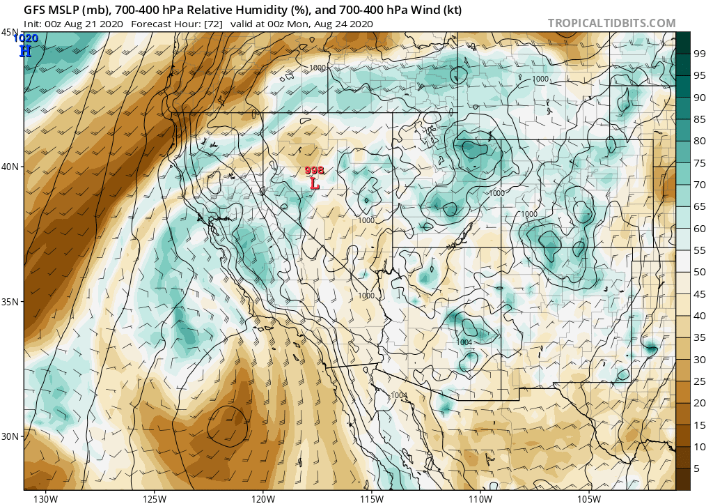
Then, slightly disconcerting news. Remnant moisture & instability from former Hurricane #Genevieve will approach CA from south on Sunday. Uncertainty remains, but right now it appears there is a real risk of *another* dry lightning event in NorCal Sun/Mon. #CAwx #CAfire (3/n) 
Absolutely incredible footage of #LoyaltonFire #pyrovortex ("Fire Tornado") earlier today. Pretty sure this validates @NWSReno's Tornado Warning--which is, I believe, the first ever issued by @NWS specifically for a wildfire-generated pyroconvective event. #CAwx #CAfire #NVwx
To be clear: this is *not* first documented instance of a large-scale fire vortex. Devastating #CarrFire in 2018 near Redding, CA produced one of the strongest such events in recent memory, outside of a couple of previous events during Australian firestorms. (1/3) #CAwx #CAfire
Such events are not a new phenomenon--they have probably occurred during particularly intense wildfires under the right atmospheric conditions since...well, time immemorial. But I suspect these recent events have been more noticeable for two key reasons: (2/3) #CAfire


