Discover and read the best of Twitter Threads about #WIwx
Most recents (6)
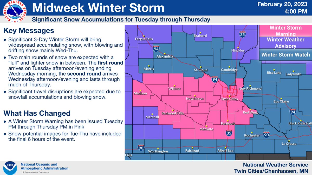
A significant winter storm remains on track to impact the region Tuesday afternoon through Thursday.
The heaviest snow & blizzard conditions are expected Wednesday afternoon through Thursday.
Significant travel impacts are anticipated until Friday. (1/6)
#mnwx #wiwx
The heaviest snow & blizzard conditions are expected Wednesday afternoon through Thursday.
Significant travel impacts are anticipated until Friday. (1/6)
#mnwx #wiwx

While new model trends are pushing the storm system on a more easterly path, high winds and new powdery snowfall will lead to the possibility of blizzard conditions Thursday night (1/6) 

1/4 | Light snow exits the area this morning, then the attention focuses on the upcoming winter storm. We continue to expect accumulating snow and very strong winds, with blizzard conditions possible Thursday night through Friday night. #wiwx 

2/4 | On top of blizzard conditions, these winds could cause damage to tree limbs resulting in the potential for sporadic power outages. Blowing and drifting snow will continue to impact travel through Saturday. #wiwx 

3/4 | While model trends have shifted southeast with the storm track and snowfall amounts remain uncertain at this time, it should be noted that we don't need significant snowfall to create blizzard conditions! #wiwx 

A strong fall storm will impact the Upper Midwest mid to late week - be prepared for heavy rain, thunderstorms, strong winds, and yes - SNOW. #MNwx #WIwx 


For some behind the scenes action, @NWSMilwaukee meteorologists were on-site @roadamerica the past 3 days to support public safety and Sheboygan County Emergency Management for the NASCAR event. 

Weather conditions were ideal, outside of some heat today though we're sure everyone was staying hydrated. In severe weather conditions, the spectators at these events need as much heads up as possible to keep them safe from the impending storms. 

We work closely with local police, fire, DOT, State Patrol and others to get the word out. We've already helped out at other events this year such as Walleye Weekend and Indycar and will also be at the Ryder Cup among others. #wiwx 

So, here is a summary of our "new normal" averages for temperature, precip, and snowfall each year in Green Bay. These might not seem like a lot, but for such a large dataset, they're fairly significant changes #wiwx
Full story: fox11online.com/weather/weathe…
THREAD w/other changes:
Full story: fox11online.com/weather/weathe…
THREAD w/other changes:

Green Bay's new coldest/hottest days, on average, have also changed.
New Coldest: 17.5° (Hi: 25.0, Lo: 10.0), warmer by 1.2° and about a week later on average (Jan 24/25)
New Hottest: 70.8° (Hi: 81.4, Lo: 60.3), warmer by 1.4° and about 2 days later on average (July 17/18)
#wiwx
New Coldest: 17.5° (Hi: 25.0, Lo: 10.0), warmer by 1.2° and about a week later on average (Jan 24/25)
New Hottest: 70.8° (Hi: 81.4, Lo: 60.3), warmer by 1.4° and about 2 days later on average (July 17/18)
#wiwx
Month in Green Bay with the BIGGEST changes in average...
Temperature: December (now 24.5°, up 3.0°!!!!)
Precipitation: May (now 4.10", up 0.42")
Snow: February (now 12.0", up 2.1")
That December number is truly wild-- easily the most drastically different month.
#wiwx
Temperature: December (now 24.5°, up 3.0°!!!!)
Precipitation: May (now 4.10", up 0.42")
Snow: February (now 12.0", up 2.1")
That December number is truly wild-- easily the most drastically different month.
#wiwx


