Discover and read the best of Twitter Threads about #MNwx
Most recents (8)
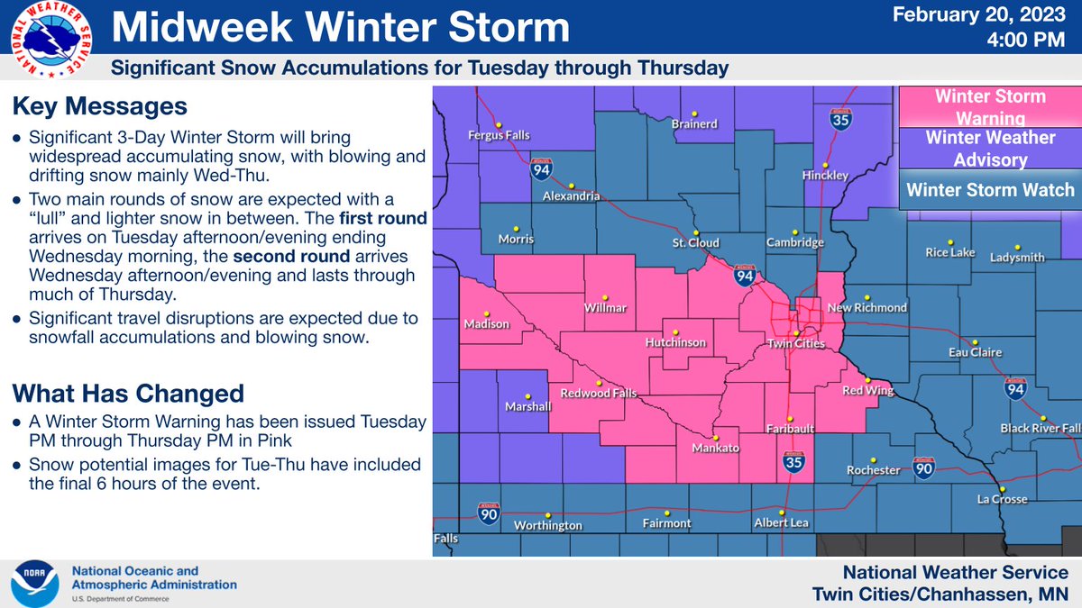
A significant winter storm remains on track to impact the region Tuesday afternoon through Thursday.
The heaviest snow & blizzard conditions are expected Wednesday afternoon through Thursday.
Significant travel impacts are anticipated until Friday. (1/6)
#mnwx #wiwx
The heaviest snow & blizzard conditions are expected Wednesday afternoon through Thursday.
Significant travel impacts are anticipated until Friday. (1/6)
#mnwx #wiwx

I normally don't do 🧵on snow events this far in advance. But the magnitude of this week's looming snow event still looks anywhere from seriously impactful, to potentially epic. Here's an early look at the most likely storm outcomes for Tuesday night through Thursday. ❄️❄️
#mnwx
#mnwx
First the system: This looks like a 2-part system. Two low-pressure waves will ride over the Rockies. Low #1 is likely to trigger a lead wave of snow across southern 1/2 of Minnesota Tuesday PM into Wednesday. Canadian model loop below between noon Tuesday and noon Wednesday.
Wave #2 is bigger and will likely cause more widespread/heavier snow across most of MN Wednesday night through Thursday. Canadian model loop below between 6 pm Wednesday and 6 pm Thursday.
Some Minnesotans reacting to a snowstorm.
1) They said a big storm is coming! ❄️❄️❄️
2) It'll probably miss us...
3) Weather enthusiasts post raw model data...
4) So when is the snow gonna get here??
5) It's snowing!
6) Snow stopped. Is this all we're gonna get???
1/4
1) They said a big storm is coming! ❄️❄️❄️
2) It'll probably miss us...
3) Weather enthusiasts post raw model data...
4) So when is the snow gonna get here??
5) It's snowing!
6) Snow stopped. Is this all we're gonna get???
1/4
7) Looks like a bust!!
8) Whoa, the snow is really coming down now...
9) That's a lot of snow!
10) The wind won't be THAT bad.
11) I can drive in anything!
2/4
8) Whoa, the snow is really coming down now...
9) That's a lot of snow!
10) The wind won't be THAT bad.
11) I can drive in anything!
2/4
3/4
A strong fall storm will impact the Upper Midwest mid to late week - be prepared for heavy rain, thunderstorms, strong winds, and yes - SNOW. #MNwx #WIwx 


An early season winter storm is expected within portions of the Dakotas into Minnesota between Thursday and Friday, likely to bring at least minor winter impacts. Impacts are expected to be mainly tied to travel conditions during this timeframe. #ndwx #mnwx 

#mnwx perspective:
100 days ago, it was almost 100° warmer than it it today - we had a record high of 75° in Saint Paul, MN on November 6.
100 days ago, it was almost 100° warmer than it it today - we had a record high of 75° in Saint Paul, MN on November 6.
Soon enough, the cycle will turn again. #mnwx 


Dec 23 #BlizzardWarning #Blizzard #Blizzard2020
#Minnesota #Kansas
Open map below, zoom in, click orange area, follow link for official NOAA details.
Travel “difficult to impossible”.
#MNwx #IAwx #NDwx #SDwx #NEwx #Blizzard
Wouldn't want to be you! Stay safe!!
#Minnesota #Kansas
Open map below, zoom in, click orange area, follow link for official NOAA details.
Travel “difficult to impossible”.
#MNwx #IAwx #NDwx #SDwx #NEwx #Blizzard
Wouldn't want to be you! Stay safe!!
Thread on MN #Blizzard traffic ... Stay home or get there as fast as you safely can.
This is a complete whiteout.
This is a complete whiteout.
Lynn Beranek from Brownton, MN has shared these photos of Friday evening's storms. | LIVE COVERAGE: cbsloc.al/2ejPN1f 


Here's another photo of Friday night's severe storms. This image comes from Jonathan Larson, southeast of Hutchinson. 

Here's another look at the apparent tornado that was spotted by Brando Allen in Brownton, MN earlier today. | LIVE COVERAGE: cbsloc.al/2ejPN1f 


