Discover and read the best of Twitter Threads about #TerraMODIS
Most recents (8)
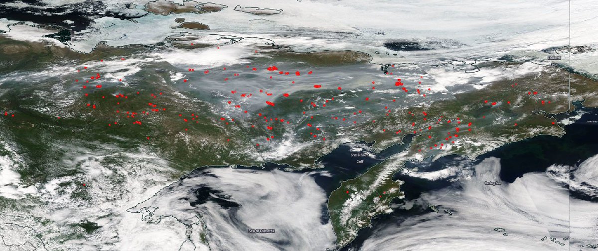
Increased daily total intensity, &smoke emissions, of active Sakha Republic #wildfires >> 2003-2018 mean in #CopernicusAtmosphere GFAS data confluence.ecmwf.int/display/CKB/CA…, comparable to only 3 previous years since 2003. #TerraMODIS🛰️ imagery go.nasa.gov/2ZYOniQ shows 23/09. 


Thick smoke from #CaliforniaFires #OregonFires crossing North America & North Atlantic reaching Iceland & Scandinavia over weekend in latest @CopernicusECMWF Atmosphere Monitoring Service @ECMWF aerosol forecast visualized by @windyforecast windy.com/-Aerosol-aod55… #wildfires
Dark area of smoke aerosol from western US #wildfires over cloud in #TerraMODIS visible imagery for 17/09 go.nasa.gov/3iIPkmz corresponding to area of high AOD in #CopernicusAtmosphere forecast for 09UTC atmosphere.copernicus.eu/charts/cams/ae… 


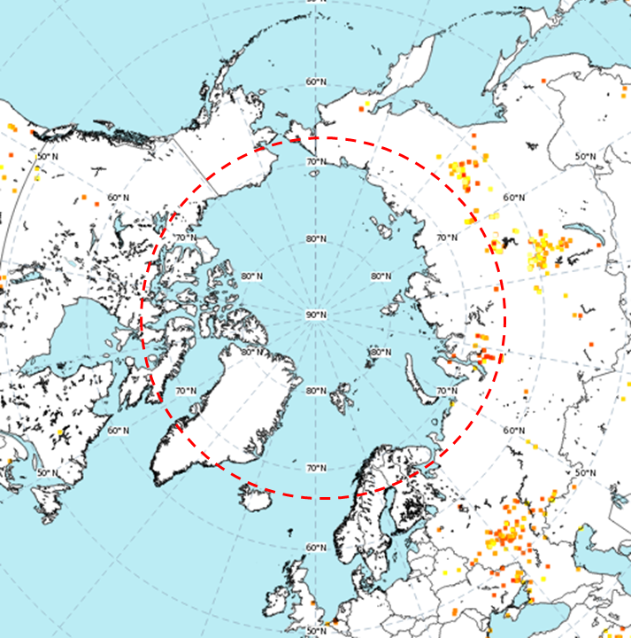
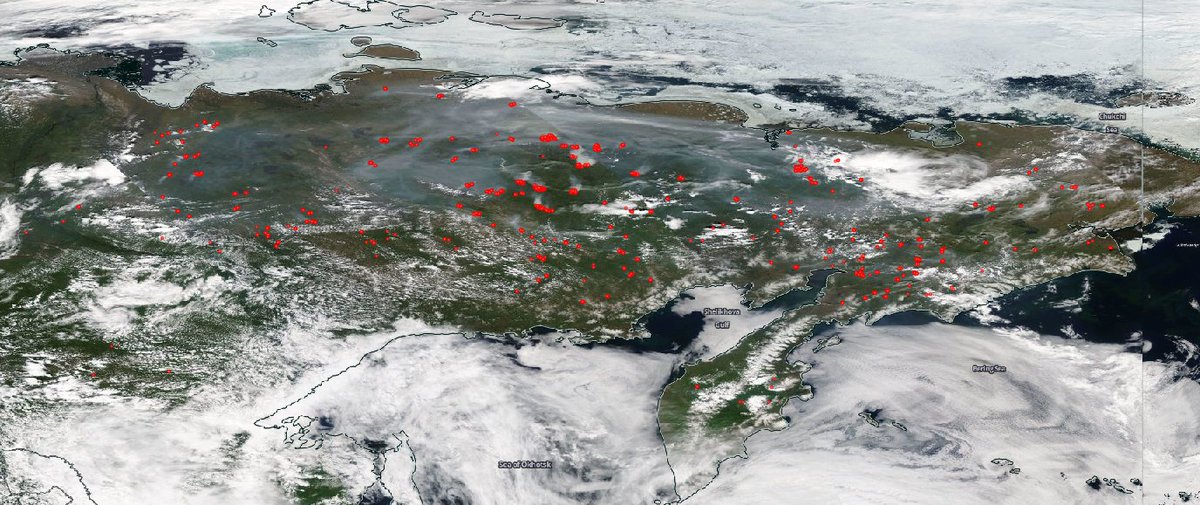
Peak #ArcticFires activity seems a long time ago but Sakha Republic & Chukotka🇷🇺still experiencing above average daily total #wildfire intensity for late August in #CopernicusAtmosphere GFAS data to 24/08. #TerraMODIS🛰️imagery shows continuation on 25/08 go.nasa.gov/3ldIDKV 


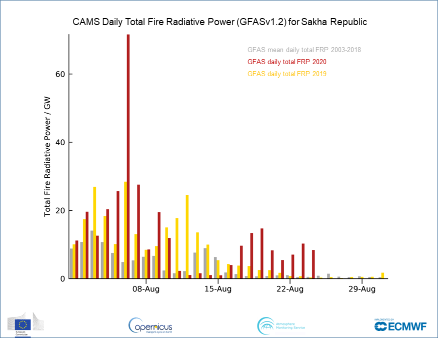
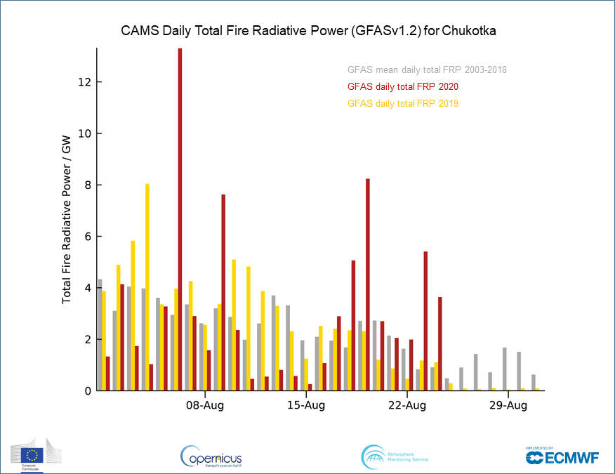

#Wildfire activity in other parts of #Siberia has been relatively low all summer. Krasnoyarsk & Irkustk have been experiencing increased daily total intensity over last 2 weeks close to 2003-2018 mean & << 2019. 


Global Fire Assimilation System data based on MODIS obs (only Terra available since 17 August)➡️ confluence.ecmwf.int/display/CKB/CA…
Latest maps➡️ atmosphere.copernicus.eu/charts/cams/fi…
NASA imagery➡️ go.nasa.gov/3ldIDKV
Latest maps➡️ atmosphere.copernicus.eu/charts/cams/fi…
NASA imagery➡️ go.nasa.gov/3ldIDKV
Increased #Siberia/#ArcticCircle #wildfire detections on 12 July atmosphere.copernicus.eu/charts/cams/fi…➡️ jump in #CopernicusAtmosphere Monitoring Service GFAS daily total intensity. #TerraMODIS🛰️ imagery on 13th shows continuation + smoke over Arctic Ocean go.nasa.gov/3epgOL8 #ArcticFires 


Number & intensity of #wildfires in NE #Siberia/#Arctic Circle has continued to increase over the last few days as shown in latest #Copernicus Atmosphere Monitoring Service GFAS analysis atmosphere.copernicus.eu/charts/cams/fi…. Daily total intensity is at similar levels to that observed in 2019. 


and expecting more of the same in tomorrow's analysis by comparing NASA #TerraMODIS satellite observations for 21 (left) & 22 (right) June go.nasa.gov/3dlHrzZ 

High surface PM10 from #calima dust storm predicted across Bay of Biscay & Iberian peninsula in #Copernicus Atmosphere Monitoring Service regional ensemble forecast macc-raq-op.meteo.fr/index.php?cate…. Porto, Lisbon & Madrid PM10 (blue bars) may exceed 50µg/m3 over next two days #airquality 


@CopernicusECMWF @ECMWF @CopernicusEU @meteofrance @ipma_pt @AEMET_Esp @Atmospheric_SAF @AntjeInness @VHPeuch @RichardJEngelen cc @SaraBasart @henk_eskes @aire_sergio_rod @DustyCRyder @DustStormNews @SanGasso @cp_garcia_pando @dust_deviler @Dust_Barcelona @edupenabad @AEMET_Galicia @AEMET_Asturias @Rafacereceda @IreneSanta_ @MarGomezH
@CopernicusECMWF @ECMWF @CopernicusEU @meteofrance @ipma_pt @AEMET_Esp @Atmospheric_SAF @AntjeInness @VHPeuch @RichardJEngelen @SaraBasart @henk_eskes @aire_sergio_rod @DustyCRyder @DustStormNews @SanGasso @cp_garcia_pando @dust_deviler @Dust_Barcelona @edupenabad @AEMET_Galicia @AEMET_Asturias @Rafacereceda @IreneSanta_ @MarGomezH NASA #TerraMODIS 🛰️ visible imagery for 27 Feb 2020 clearly showing desert dust over northern Spain & Portugal between the clouds go.nasa.gov/3983pp0 #calima #AirQuality 

Smoke from Parque Nacional Pantanal do Matogrossense🇧🇷 #wildfires as seen in today's #Copernicus Atmosphere Monitoring Service aerosol forecast atmosphere.copernicus.eu/charts/cams/ae… & NASA #TerraMODIS
🛰️ imagery go.nasa.gov/37AzpRM. GFAS data show daily total FRP > 2003-19 average.


🛰️ imagery go.nasa.gov/37AzpRM. GFAS data show daily total FRP > 2003-19 average.


@CopernicusECMWF @ECMWF @CopernicusEU @CopernicusEMS @CopernicusLand @inpe_mct @NASAEarth @ESA_EO @Atmospheric_SAF @Pierre_Markuse cc @ccst_inpe @INPE_CPTEC @TREES_Research @camilafloresta1 @dsrinpe @DomSpracklen @pjyng @CLSReddington @thi_sanna @celsohlsj @GuidovanderWerf @cwiedinm @KCLwildfire_EO @centrewildfires
@CopernicusECMWF @ECMWF @CopernicusEU @CopernicusEMS @CopernicusLand @inpe_mct @NASAEarth @ESA_EO @Atmospheric_SAF @Pierre_Markuse reposted with correct graphics @Pierre_Markuse @Bewickwren
Moving on from #Asteroids #Exoplanets #SolarEclipse #StarSpectrum we now focus on #Satellites
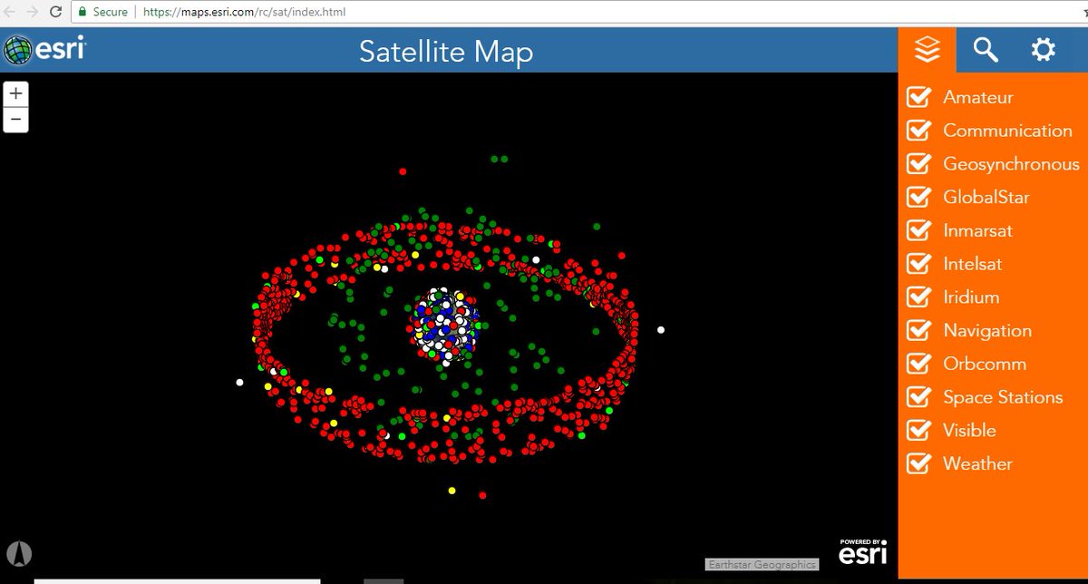
Sputnik 1 was the first satellite to be launched (1957). Over 1200 active satellites are currently orbiting Earth.
Check out the LIVE Satellite Map maps.esri.com/rc/sat/index.h…
Sputnik 1 was the first satellite to be launched (1957). Over 1200 active satellites are currently orbiting Earth.
Check out the LIVE Satellite Map maps.esri.com/rc/sat/index.h…
Satellites come in different sizes: from the size of a lunch box to that of a small school bus.
And they are used for different purposes: Climate Monitoring, Agriculture, Telecommunications, Research....
And they are used for different purposes: Climate Monitoring, Agriculture, Telecommunications, Research....

Can #CitizenScientists access data from these satellites?
Yes! NASA makes available near LIVE data from many of its satellites in an interactive interface.
Allows browsing full-resolution, global satellite imagery!
worldview.earthdata.nasa.gov
Use it for your projects!
Yes! NASA makes available near LIVE data from many of its satellites in an interactive interface.
Allows browsing full-resolution, global satellite imagery!
worldview.earthdata.nasa.gov
Use it for your projects!
