Discover and read the best of Twitter Threads about #ILwx
Most recents (14)
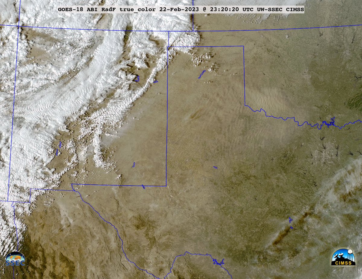
True Color RGB images from @NOAASatellites #GOES16/#GOESeast showed large plumes of blowing #dust across parts of New Mexico, Texas ad Oklahoma on 22 Feb: geosphere.ssec.wisc.edu/#playing:true;…; Note the brighter white plume originating from White Sands NM. #NMwx #TXwx #OKwx
...and here's a comparison of the blowing dust plumes as viewed using True Color RGB images from 3 satellites - @NOAASatellites #GOES18/#GOESwest, #GOES17 and #GOES16/#GOESeast: cimss.ssec.wisc.edu/satellite-blog… #NMwx #TXwx #OKwx 




This morning, evidence of the airborne dust (shades of tan) from NM/TX/OK could be seen in @NOAASatellites #GOES16/#GOESeast True Color RGB images over parts of #ILwx/#INwx/#OHwx/#MIwx/#KYwx: geosphere.ssec.wisc.edu/#playing:true;…;
Spent the morning exploring Chicago's lakefront (a thread). First up, some lazy waves with the skyline from the North Ave lakefront path. #ilwx
Some low clouds, some high clouds and a splash of color in the sky and on the lake.
The sun makes an appearance from the North Ave Pier with some thin ice formations on the Lake Michigan.
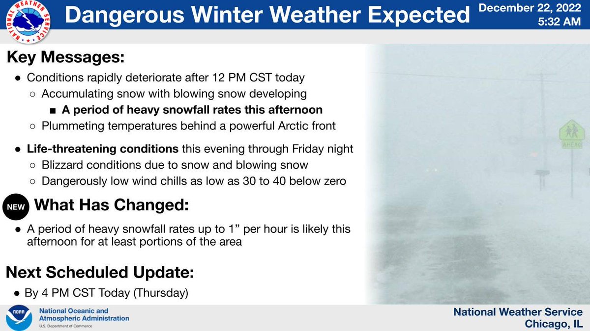
[3:20 PM CST 12/22] Here are key messages for the continued winter weather through tomorrow. Gusty winds and dangerously cold temperatures will become the norm tonight and especially Friday. Stay indoors, if you can! #ILwx #INwx 

.Thu 12/22 AM Update! 1) Key Messages for the Dangerous Winter Weather Today-Early Saturday:
Conditions will deteriorate quickly late AM-aftn hours with snow, gusty winds & plummeting temperatures. The snow will taper on Friday though dangerous cold will remain. #ILwx #INwx (1/6)
Conditions will deteriorate quickly late AM-aftn hours with snow, gusty winds & plummeting temperatures. The snow will taper on Friday though dangerous cold will remain. #ILwx #INwx (1/6)
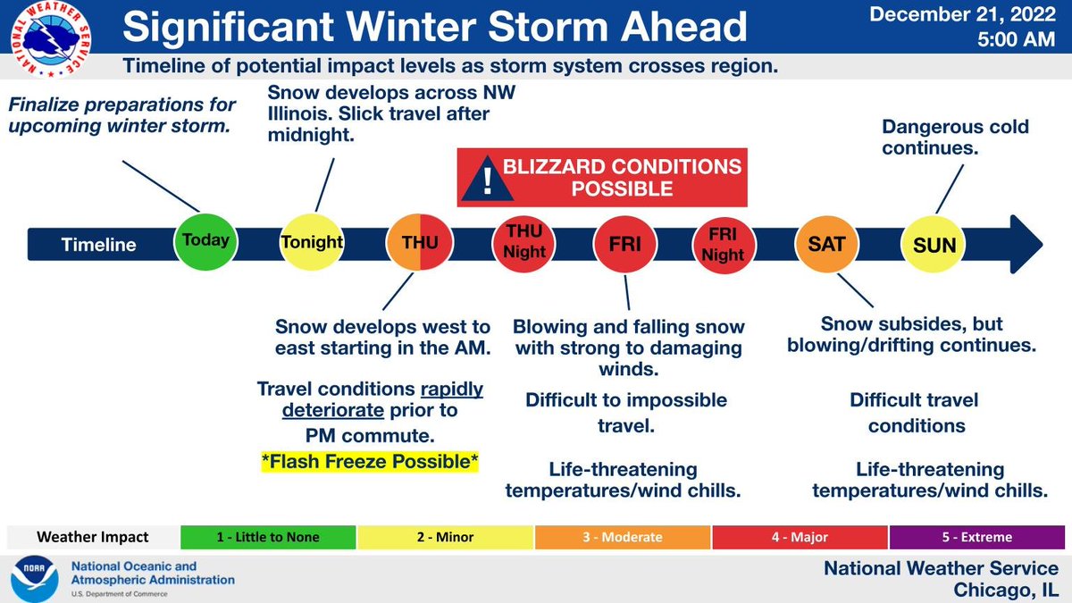
.Wed AM update! 1) Key messages on the dangerous winter weather Thursday into the holiday wknd. A powerful storm system will bring strong winds, falling and blowing & drifting snow, & extreme cold. Worst conditions: Thu-Fri. Threat for flash freeze on Thursday! #ILwx #INwx (1/5) 

[4:00 AM 12/20] Confidence in a major winter storm continues to increase for the Thursday to Saturday time frame. Blizzard conditions are possible, and travel looks to become severely impacted, particularly Thursday night through Friday afternoon. #ILwx #INwx 

Major winter storm Thu thru Sat with heavy snow, strong winds, severe blowing/drifting snow & bitter cold. The worst conditions will develop Thu evening & continue into Fri evening when a full fledged blizzard is possible along with dangerously cold temp. #ilwx #inwx 

(1/3) The air has been notably dry to start June, a month that typically sees humid air masses become more frequent.
Dew points have entirely been below 50° for the past two days, and Friday's dew points actually were near record low for the time of year.
#ILwx #INwx
Dew points have entirely been below 50° for the past two days, and Friday's dew points actually were near record low for the time of year.
#ILwx #INwx

(1/5) This hour of tornado safety for Illinois #SeverePrep Week: Know the difference between a watch and a warning and what to do during a watch #ilwx
(2/5) Do you know the difference between severe weather WATCHES and WARNINGS? A WATCH means severe storms or tornadoes might form and affect your area. A WARNING means it’s time to take action! A severe storm or tornado is expected in your area. #SeverePrep #ILwx 

(3/5) Specific terminology for tornadoes
• Note that a Tornado Emergency is an exceedingly rare situation (such as the Kentucky tornadoes back on Dec 10, 2021) with a confirmed violent tornado posing a severe threat to life & catastrophic damage
#SeverePrep #ilwx
• Note that a Tornado Emergency is an exceedingly rare situation (such as the Kentucky tornadoes back on Dec 10, 2021) with a confirmed violent tornado posing a severe threat to life & catastrophic damage
#SeverePrep #ilwx

(1/4) Continuing the theme of this morning's Twitter tornado drill, we'll continue with tornado safety on day 2 of Illinois #SeverePrep Week. This hour, what to do BEFORE a tornado. #ilwx
(2/4) Some people are especially vulnerable to the dangers of tornadoes.
Those with a lower level of mobility, such as the elderly or disabled, or those who live in mobile homes, may need your help to prepare & stay safe & #WeatherReady. #SeverePrep #ilwx weather.gov/safety/tornado
Those with a lower level of mobility, such as the elderly or disabled, or those who live in mobile homes, may need your help to prepare & stay safe & #WeatherReady. #SeverePrep #ilwx weather.gov/safety/tornado

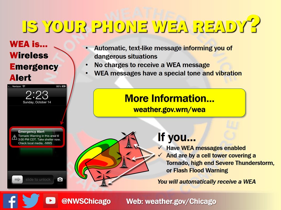
(3/4) Keep Wireless Emergency Alerts for tornado and flash flood warnings enabled on your cell phone. They can save your life! Find out more at ready.gov/alerts & weather.gov/wrn/wea #SeverePrep #ilwx 


Good morning! Here are three graphics/tweets to summarize heavy snow later today & freezing rain overnight.
Impacts will be seen to this eve's commute, and they may be significant in places due to heavy snow rates. Plan accordingly & use travel flexibility if able. #ILwx #INwx
Impacts will be seen to this eve's commute, and they may be significant in places due to heavy snow rates. Plan accordingly & use travel flexibility if able. #ILwx #INwx

Good morning!☀️ Let's talk Monday's storms.
A long-lived, large storm complex tracked from the NE/IA border, across IA, northern IL, & northern IN. This produced widespread damage to trees, toppled several semis, & caused some structure damage.
Recap: weather.gov/lot/2020aug10
A long-lived, large storm complex tracked from the NE/IA border, across IA, northern IL, & northern IN. This produced widespread damage to trees, toppled several semis, & caused some structure damage.
Recap: weather.gov/lot/2020aug10
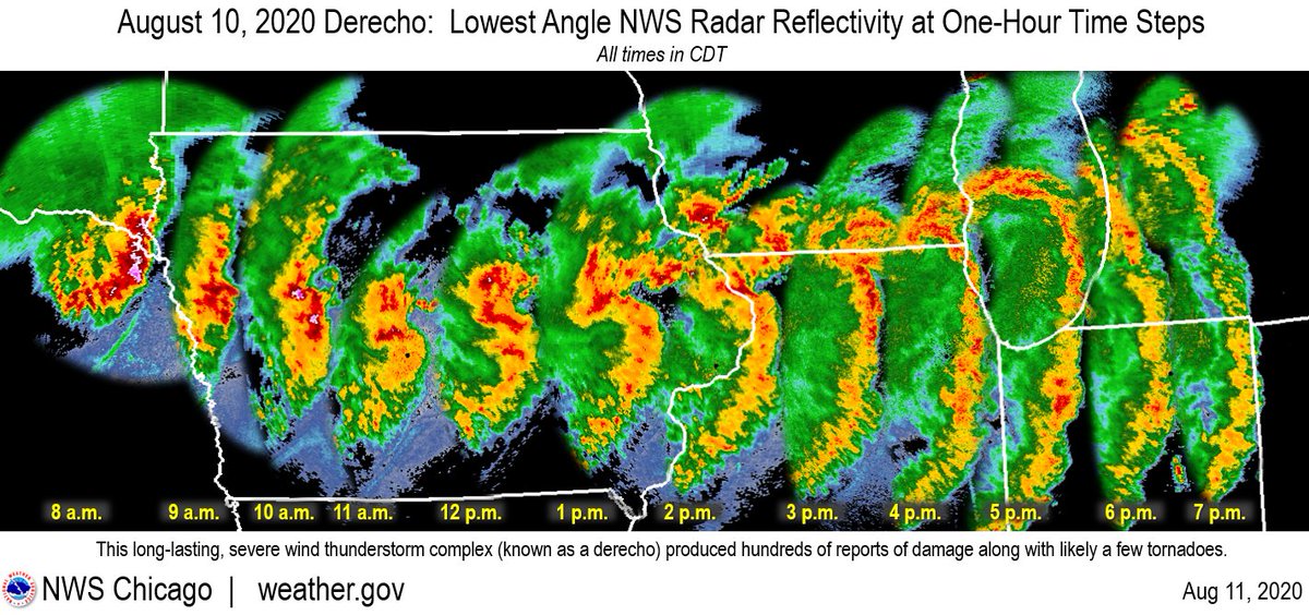
The peak gusts (measured & estimated) were frequently 70-90 mph & persisted for 15+ minutes with some locations experiencing even higher. These wind speeds are equivalent to EF-0 to EF-1 tornadoes but over a vastly larger area than a tornado would impact. #ILwx 
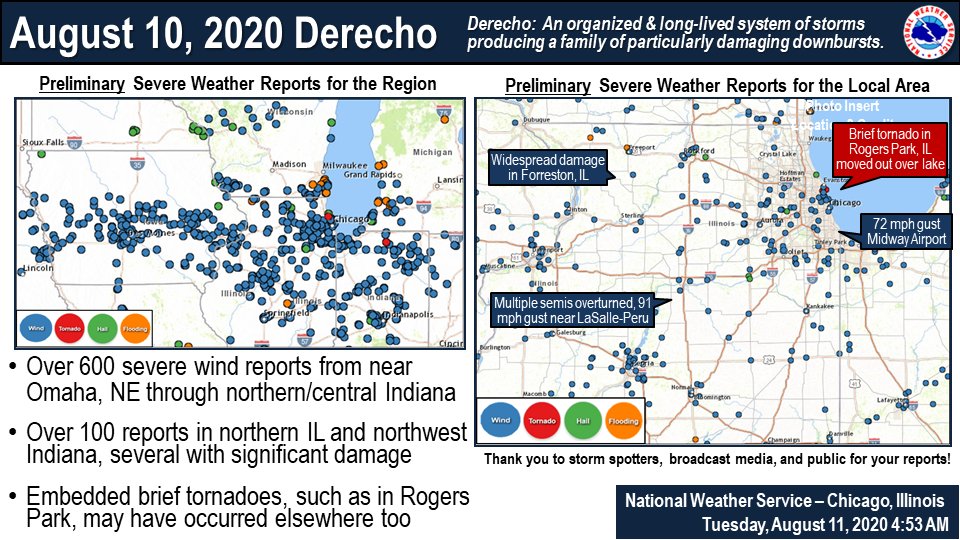
While much of the wind damage was straight-line wind, a few tornadoes were likely embedded within the storm complex across the region, and one has been confirmed in Rogers Park, IL. This did move out over Lake MI becoming a waterspout. #ILwx 
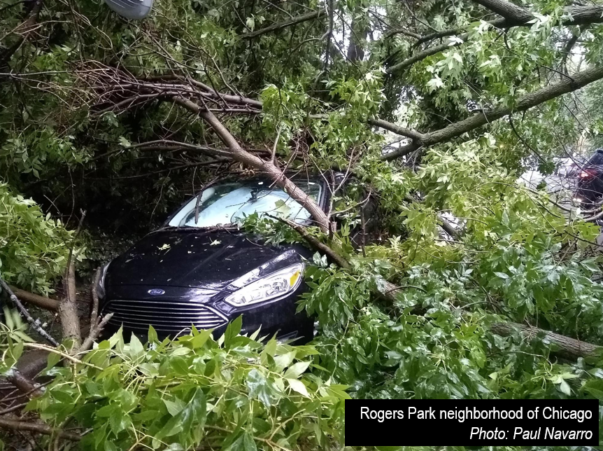
@NWSChicago Damage Report - Large tree down on parked cars, 1450 W Addison. Multiple other small trees and branches down in area. #ilwx 

@NWSChicago Damage Report - 4752 N Paulina, large tree down. CFD responded for a minor gas leak. Another tree down further down the block, so vehicles on the block are trapped. #ilwx 

@NWSChicago Damage Report - SIGNIFICANT Damage in a 4 block radius of Hamlin & Montrose. Multiple trees down, roof blown off porch, windows broken. #ilwx 


So all that and no storms? What happened?
We had all the ingredients we needed in abundance: moisture, heating, instability, increasing winds above the surface. We knew we would have all these severe thunderstorm ingredients at the ready today. (1/4)
We had all the ingredients we needed in abundance: moisture, heating, instability, increasing winds above the surface. We knew we would have all these severe thunderstorm ingredients at the ready today. (1/4)
(2/4) Well then, why no storms?
We anticipated storms to focus along the dry line, a boundary between very dry air & very moist air. The dry line moved across MO as expected but we didn't have enough air colliding at the surface to rise and form thunderstorms!
We anticipated storms to focus along the dry line, a boundary between very dry air & very moist air. The dry line moved across MO as expected but we didn't have enough air colliding at the surface to rise and form thunderstorms!
(3/4) Sometimes that's all it takes, one missing ingredient and the day looks completely different than what we expected.


