Discover and read the best of Twitter Threads about #pawx
Most recents (6)
1/5 Sleet & frz. rain will overspread the Lower Susquehanna Valley from southwest-to-northeast between ~ 10 p.m. and midnight. Temps. will be within a degree or two of freezing for much of the night, and roadway temps. are still above freezing following the recently warmth..
2/5 I'm expecting a few hundredths to one tenth of an inch of frz. rain to the south of the PA Turnpike & east of Route 15.. with 0.10-0.25" of ice in areas farther north & west. The greatest chance of 0.25" of ice will be north/west of the I-81/78 corridors..
3/5 These expected ice amounts are with respect to trees & power lines. Primary roadways should generally remain wet, but secondary, untreated roads will turn icy overnight. Temps. will slowly rise above freezing from south-to-north btw. 4 & 8 a.m., causing ice to turn to rain..
NOTABLE OCTOBER CLIMATE INFORMATION:
October 2021 will be remembered for its persistent warmth and lack of cold nights. As we approach the end of the month, let's contextualize the record-setting warmth at @flyHIA (MDT), @flyIPT (IPT), & State College (STC).
(1/5)
#PAwx
October 2021 will be remembered for its persistent warmth and lack of cold nights. As we approach the end of the month, let's contextualize the record-setting warmth at @flyHIA (MDT), @flyIPT (IPT), & State College (STC).
(1/5)
#PAwx
LACK OF COLD NIGHTS IN OCTOBER 2021:
MDT did not drop below 43°F for only the 2nd time since 1888 (134 yrs)
IPT failed to reach 38°F for the 1st time since records began in 1895 (127 yrs)
STC failed to reach 38°F 1st time since records began in 1893 (129 yrs)
(2/5)
#PAwx
MDT did not drop below 43°F for only the 2nd time since 1888 (134 yrs)
IPT failed to reach 38°F for the 1st time since records began in 1895 (127 yrs)
STC failed to reach 38°F 1st time since records began in 1893 (129 yrs)
(2/5)
#PAwx
PERSISTENT MILD NIGHTS:
Current records for highest average low temperature (°F) in October:
MDT: 53.6 (1984), IPT: 50.1 (2007), STC: 49.8 (2007)
October-to-date 2021 (difference from record):
MDT: 55.1 (+1.5), IPT: 52.0 (+1.8), STC: 51.8 (+2.0)
(3/5)
#PAwx
Current records for highest average low temperature (°F) in October:
MDT: 53.6 (1984), IPT: 50.1 (2007), STC: 49.8 (2007)
October-to-date 2021 (difference from record):
MDT: 55.1 (+1.5), IPT: 52.0 (+1.8), STC: 51.8 (+2.0)
(3/5)
#PAwx
I’m going go out on a limb here and say someone in this highlighted area is probably going to get a foot plus of rain tomorrow. Not widespread to be clear but isolated totals 12”+ are definitely reasonable. I’ll explain below👇 #pawx #njwx #ida #rain #flooding 

Okay, so going to get my normal updates, client stuff done right now. Let me lay out the rules for Live Coverage so everyone is clear.
1. When you share observations please provide town and state. Also adding a #nywx #njwx #pawx etc helps the @NWS_MountHolly and @NWSNewYorkNY
2. I don't do IMBY questions in general, and especially not in a storm. That is the Premium Live Coverage, which I'll be doing starting at 5 PM until either I pass out or the storm is over. Whichever is first.
Good morning everyone! HAPPY SUNDAY!!
Snow has started in southern Delaware and the Washington, D.C. metropolitan area already. Clouds are on the increase with temperatures ranging from the single digits in the Catskills to the upper 20s in Cape May, New Jersey. 

Updates are on the way with the latest watches and warnings and a public update from our intern @MichaelBrownewx ! No changes to the going forecast at all. I've been pretty much locked in on this storm since Friday. 

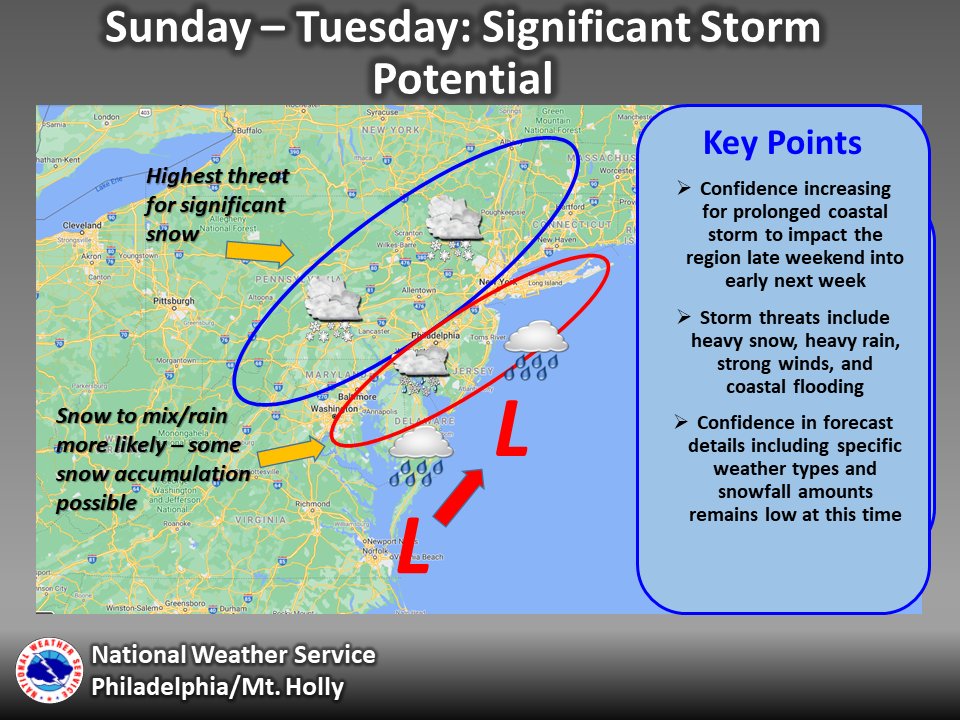
There is an increasing threat for a significant and potentially prolonged coastal storm system to impact the region late this weekend into next week. Here are the key points: (thread) #NJWX #MDWX #DEWX #PAWX 

Precip could arrive as early as mid day Sunday & likely start as snow for most. Snow should continue for several hours into Sunday night with precipitation gradually becoming heavier by the overnight into Monday morning as winds also increase.
Snow and rain, potentially heavy at times, are likely to affect the region Monday along with strong northeast winds. There is uncertainty on where the rain/snow line will be during this time as it will depend on the exact track and evolution of the storm


