Discover and read the best of Twitter Threads about #chennaiweather
Most recents (4)
Long post alert
There has been a lot of talk about what is likely to happen for #Chennai and the surrounding districts in the next 4 days.
And it's been a while since I last gave a concrete update and so this I feel is the time to give one
#chennairains #chennaiweather (1/n)
There has been a lot of talk about what is likely to happen for #Chennai and the surrounding districts in the next 4 days.
And it's been a while since I last gave a concrete update and so this I feel is the time to give one
#chennairains #chennaiweather (1/n)
To answer the big question here.
Will #Chennai and surrounding districts get heavy to very heavy rains as being discussed everywhere.
The straightforward answer would be a big "YES".
HEAVY TO VERY HEAVY RAINFALL IS VERY LIKELY IN THE NEXT 4 DAYS FOR CHENNAI AND SURROUNDINGS.
Will #Chennai and surrounding districts get heavy to very heavy rains as being discussed everywhere.
The straightforward answer would be a big "YES".
HEAVY TO VERY HEAVY RAINFALL IS VERY LIKELY IN THE NEXT 4 DAYS FOR CHENNAI AND SURROUNDINGS.
The next question that is being is being widely asked is why?
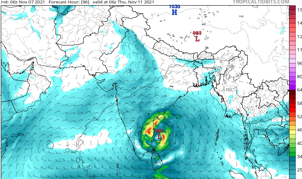
There is a low pressure area that is forming and taking shape in the Central Bay of Bengal region and is likely to move west towards Northern #Tamilnadu coast
It can become a well marked low and at best, a depression
There is a low pressure area that is forming and taking shape in the Central Bay of Bengal region and is likely to move west towards Northern #Tamilnadu coast
It can become a well marked low and at best, a depression
Waited for the last week or so- to have a consensus - but I suppose before a consensus, rains could lash. Hence posting this.
Extreme rainfall alert once again for #Chennai
#ChennaiRains2021 #Chennai #ChennaiRains #chennaiflood #ChennaiRain #chennaiweather #TamilNadu

Extreme rainfall alert once again for #Chennai
#ChennaiRains2021 #Chennai #ChennaiRains #chennaiflood #ChennaiRain #chennaiweather #TamilNadu


Twin circulations on both sides of the Indian Peninsula decide the fate of #Chennairains now. With the MJO in Phase 3- firmly - indications of an easterly surge and also a low-level circulation would increase the convective activity over #Central and #Northern #TamilNadu
Moderate rainfall for #Chennai to start from the evening. Southern suburbs ECR OMR Region would experience moderate to heavy rainfall from afternoon City will start to get rains from evening. Rains are expected through night and tomorrow it is going to be heavy to extremely heavy
91B is gradually intensifying and rainfall will gradually increase over the course of the day.
Whatever warnings that were given still hold good.
Avoid venturing out.
#ChennaiRains #Chennai #ChennaiRain #chennaifloods #ChennaiRains2021 #ChennaiFlood #chennaiweather
Whatever warnings that were given still hold good.
Avoid venturing out.
#ChennaiRains #Chennai #ChennaiRain #chennaifloods #ChennaiRains2021 #ChennaiFlood #chennaiweather
#Nellore to #Karaikkal coast to be on high alert as the system is consolidating and the cloud bands are getting organized- slowly and steadily.
This would mean that rains will be more as the system nears the coast
This would mean that rains will be more as the system nears the coast
Now that the #rain has stopped for a while in #Chennai, it is time that we get to know what we can expect this week.
1. A Low-pressure area will likely form in the next 2 days in the Southeast #BayofBengal region.
2. Owing to favourable conditions this will further intensify.
1. A Low-pressure area will likely form in the next 2 days in the Southeast #BayofBengal region.
2. Owing to favourable conditions this will further intensify.

3. Preliminary analysis suggests that this system will likely intensify as deep depression and would move towards Coastal #TamilNadu
4. Possibility of this system intensifying into a cyclone exists. Which means a named #cyclone is a possibility
4. Possibility of this system intensifying into a cyclone exists. Which means a named #cyclone is a possibility
5. Assuming that it becomes a named cyclone, this would be named "#Jawad" named by #SaudiArabia
6. The track that it is likely to take is that it will climb up Northwest - intensify near the coast and move lateral west in between #Chennai and #Pondicherry
6. The track that it is likely to take is that it will climb up Northwest - intensify near the coast and move lateral west in between #Chennai and #Pondicherry

