Discover and read the best of Twitter Threads about #SHAKING
Most recents (24)
taeyang ft. jimin - vibe mv.
analysis & symbolism
this whole song is about the pending darkness, the golden dawn/age (sunrise code word), the awakening of the spirit of kundalini (fiery serpent), the collusion between the dimensions all coming together.
analysis & symbolism
this whole song is about the pending darkness, the golden dawn/age (sunrise code word), the awakening of the spirit of kundalini (fiery serpent), the collusion between the dimensions all coming together.

#REPENT #bts #bigbang #jimin #parkjimin #taeyang #theblacklabel #hybe #vibe #kpop #kpopilluminati #kpopexposed #exposed #illuminati #바이브 #태양 #지민 #더블랙레이블 #방탄소년단 #vibration #shaking #Revelation #mars #kundalini #awakening #endtimes #war #saturn #ring #mercury
the rest of the analysis is from days ago and you can find it here if interested
#Shaking detected
#揺れが検出されました
5.4MB #Magnitude #Earthquake
5.4MB #マグニチュード #地震
#Matico, #Chuquisaca, #Bolivia
#マティコ、#チュキサカ、#ボリビア
Depth 591km
深さ: 591km
2021/03/21| 14:17:16UTC/
GPS: -19.49, -63.96
reported by #emsc_Seismicportal
#揺れが検出されました
5.4MB #Magnitude #Earthquake
5.4MB #マグニチュード #地震
#Matico, #Chuquisaca, #Bolivia
#マティコ、#チュキサカ、#ボリビア
Depth 591km
深さ: 591km
2021/03/21| 14:17:16UTC/
GPS: -19.49, -63.96
reported by #emsc_Seismicportal

Following image shows the day plot of Seismograph GT-LPAZ (#LaPaz, #Bolivia) unfiltered and unchanged.
Distance between epiccenter and Seismograph 566KM.

Distance between epiccenter and Seismograph 566KM.


Following Seismograph GT-LPAZ (#LaPaz, #Bolivia distance 566 km to epicenter) plays the audio of the 5.2 (USGS)- 5.4 (#emsc_Seismicportal) Earthquake.
GPS Seismograph: -16.288, -68.131
GPS Seismograph: -16.288, -68.131
#Shaking detected
#揺れが検出されました
5.0MB #Magnitude #Earthquake
5.0MB #マグニチュード #地震
87 km South Southwest of #Uyuni, #Bolivia
#ボリビア、 ウユニの南南西87 km
Depth 182km
深さ: 182km
2021/03/21| 10:55:27UTC/
GPS: -21.1683, -67.1967
reported by @USGS
#揺れが検出されました
5.0MB #Magnitude #Earthquake
5.0MB #マグニチュード #地震
87 km South Southwest of #Uyuni, #Bolivia
#ボリビア、 ウユニの南南西87 km
Depth 182km
深さ: 182km
2021/03/21| 10:55:27UTC/
GPS: -21.1683, -67.1967
reported by @USGS

Selected Seismograph Station
Limon Verde, Chile
Seismographcode: GE-LVC
GPS: -22.61,-68.91
Elevation: 2960 m
-
選択された地震計ステーション
#チリ、 リモンヴェルデ
地震計:GE-LVC
GPS:-22.61、-68.91
標高:2960 m
#Bolivia #Earthquake
#ボリビア #地震
Limon Verde, Chile
Seismographcode: GE-LVC
GPS: -22.61,-68.91
Elevation: 2960 m
-
選択された地震計ステーション
#チリ、 リモンヴェルデ
地震計:GE-LVC
GPS:-22.61、-68.91
標高:2960 m
#Bolivia #Earthquake
#ボリビア #地震
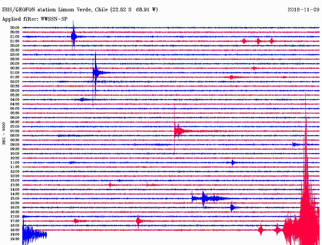
#Shaking detected
#揺れが検出されました
5.4MB #Magnitude #Earthquake
5.4MB #マグニチュード #地震
Guerrero, Mexico
#メキシコ、ゲレロ
Depth 40km
深さ: 40km
2021/03/20| 03:06:35UTC/
GPS: 16.84, -98.65
reported by #emsc_Seismicportal
#揺れが検出されました
5.4MB #Magnitude #Earthquake
5.4MB #マグニチュード #地震
Guerrero, Mexico
#メキシコ、ゲレロ
Depth 40km
深さ: 40km
2021/03/20| 03:06:35UTC/
GPS: 16.84, -98.65
reported by #emsc_Seismicportal

*
Yoloxóchitl, Guerrero, Mexico
Yoloxóchitl, Guerrero, Mexico
According to USGS:
5.7MWW Magnitude Earthquake 7 km north of Marquelia, Mexico
--
USGSによると:
メキシコ、マルケリアの北7kmにある5.7MWWマグニチュード地震
#地震 #メキシコ
#Earthquake #Mexico
5.7MWW Magnitude Earthquake 7 km north of Marquelia, Mexico
--
USGSによると:
メキシコ、マルケリアの北7kmにある5.7MWWマグニチュード地震
#地震 #メキシコ
#Earthquake #Mexico
I getting reports of a 5.7 earthquake in Greece, data follows.
#Shaking detected
#揺れが検出されました
5.1 MWW #Magnitude #Earthquake
5.1 MWW #マグニチュード #地震
49 km WSW of Bolitoc, #Philippines
#フィリピン、ボリトックの西南西49 km
Depth 10Km
深さ: 10km
2021/03/11| 07:24:37UTC
GPS: 15.6232, 119.4285
reported by @USGS
#揺れが検出されました
5.1 MWW #Magnitude #Earthquake
5.1 MWW #マグニチュード #地震
49 km WSW of Bolitoc, #Philippines
#フィリピン、ボリトックの西南西49 km
Depth 10Km
深さ: 10km
2021/03/11| 07:24:37UTC
GPS: 15.6232, 119.4285
reported by @USGS

I m not able to recive usefull seismic recordings as nearby ones showing error.
(Seismograph -> offline)
(Seismograph -> offline)
#Shaking detected
#揺れが検出されました
5.2 MB #Magnitude #Earthquake
5.2 MB #マグニチュード #地震
#Nzongomintangui, #Gabon
#ンぞンゴミンタングイ #ガボン
Depth 10Km
深さ: 10km
2021/03/09| 23:07:56UTC
GPS: -1.06, 10.21
reported by #emsc_Seismicportal
#揺れが検出されました
5.2 MB #Magnitude #Earthquake
5.2 MB #マグニチュード #地震
#Nzongomintangui, #Gabon
#ンぞンゴミンタングイ #ガボン
Depth 10Km
深さ: 10km
2021/03/09| 23:07:56UTC
GPS: -1.06, 10.21
reported by #emsc_Seismicportal

According to @USGS:
5.4 #Magnitude #earthquake 33 km Northwest of Fougamou, #Gabon
@USGSによると:5.4 #マグニチュード、 #地震、 ガボンのフガムーの北西33 km
5.4 #Magnitude #earthquake 33 km Northwest of Fougamou, #Gabon
@USGSによると:5.4 #マグニチュード、 #地震、 ガボンのフガムーの北西33 km
#Shaking detected
#揺れが検出されました
5.0 #Magnitude #Earthquake
5.0 #マグニチュード #地震
21.9 km Northeast of Sigöldustöð, #Iceland
#アイスランド、Sigöldustöðの北東21.9 km
Depth 4.2Km
深さ: 4.2km
2021/02/24| 10:15:01UTC
GPS: 64.326-18.822
reported by @Vedurstofan
#揺れが検出されました
5.0 #Magnitude #Earthquake
5.0 #マグニチュード #地震
21.9 km Northeast of Sigöldustöð, #Iceland
#アイスランド、Sigöldustöðの北東21.9 km
Depth 4.2Km
深さ: 4.2km
2021/02/24| 10:15:01UTC
GPS: 64.326-18.822
reported by @Vedurstofan

According to @USGS
5.6MWW Magnitude Earthquake 4km Eastnorth east of Grindavík, Iceland
deep: 10km
63.862°N 22.358°W
5.6マグニチュード地震アイスランド、グリンダヴィークの東北東4km
深さ:10km
63.862°N 22.358°W
5.6MWW Magnitude Earthquake 4km Eastnorth east of Grindavík, Iceland
deep: 10km
63.862°N 22.358°W
5.6マグニチュード地震アイスランド、グリンダヴィークの東北東4km
深さ:10km
63.862°N 22.358°W
#Shaking detected
#揺れが検出されました
5.4MB #Magnitude #Earthquake
5.4MB #マグニチュード #地震
Mandijan, #Isfahan, #Iran
マンディジャン、#イスファハン、#イラン
Deep 30Km
深い: 30km
2021/02/17| 18:35:37UTC
GPS: 31.09, 51.47
reported by #emsc_Seismicportal
#揺れが検出されました
5.4MB #Magnitude #Earthquake
5.4MB #マグニチュード #地震
Mandijan, #Isfahan, #Iran
マンディジャン、#イスファハン、#イラン
Deep 30Km
深い: 30km
2021/02/17| 18:35:37UTC
GPS: 31.09, 51.47
reported by #emsc_Seismicportal

According to USGS:
"26 km Northwest of Yasuj, Iran""
"イラン、ヤースージュの北西26 km"
#Iran #Earthquake
#イラン、#地震
"26 km Northwest of Yasuj, Iran""
"イラン、ヤースージュの北西26 km"
#Iran #Earthquake
#イラン、#地震
IMPORTANT UPDATE 🚨
#IRAN #SISKAT #EARTHQUAKE #地震
According to official estimates, more than 43 people have been confirmed injured so far, while the townspeople of Siskat wanted to stay outside for fear of aftershocks. The earthquake occured at 22:05 local time
1/4
#IRAN #SISKAT #EARTHQUAKE #地震
According to official estimates, more than 43 people have been confirmed injured so far, while the townspeople of Siskat wanted to stay outside for fear of aftershocks. The earthquake occured at 22:05 local time
1/4
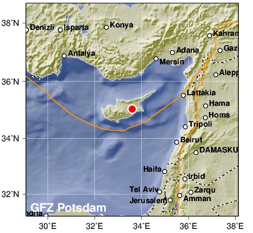
#Shaking detected
5.4 MB #Magnitude #Earthquake reported
#Cyprus region, #Cyprus
10KM deep
2021/01/21| 14:27:03 UTC
GPS: 33.60, 35.04
reported by @GFZ

5.4 MB #Magnitude #Earthquake reported
#Cyprus region, #Cyprus
10KM deep
2021/01/21| 14:27:03 UTC
GPS: 33.60, 35.04
reported by @GFZ

BREAKING
A 4.7 MAGNITUDE #EARTHQUAKE HIT ANKARA, , THE CAPITAL OF TURKEY. ITS ALSO THE EPICCENTER MORE DETIALS FOLLOW🚨
A 4.7 MAGNITUDE #EARTHQUAKE HIT ANKARA, , THE CAPITAL OF TURKEY. ITS ALSO THE EPICCENTER MORE DETIALS FOLLOW🚨
#Shaking detected
4.7ML #Magnitude #Earthquake reported
Central Turkey, #Gölköy, #Ankara, #Turkey
7KM deep
2020/01/10| 19:53:01 UTC
GPS: 40.06, 33.32
reported by #emsc_Seismicportal
4.7ML #Magnitude #Earthquake reported
Central Turkey, #Gölköy, #Ankara, #Turkey
7KM deep
2020/01/10| 19:53:01 UTC
GPS: 40.06, 33.32
reported by #emsc_Seismicportal

#Shaking detected
5.8MB #Magnitude #Earthquake reported
#Sijes, #Jujuy, #Argentina
189KM deep
2020/01/10| 03:54:11 UTC
GPS: -24.04, -66.69
reported by #emsc_Seismicportal
5.8MB #Magnitude #Earthquake reported
#Sijes, #Jujuy, #Argentina
189KM deep
2020/01/10| 03:54:11 UTC
GPS: -24.04, -66.69
reported by #emsc_Seismicportal

According to @USGS #Earthquake
6.1MWW - 42 km WNW of San Antonio de los Cobres, #Argentina
203KM deep
GPS: -24.02, -66.6723
6.1MWW - 42 km WNW of San Antonio de los Cobres, #Argentina
203KM deep
GPS: -24.02, -66.6723
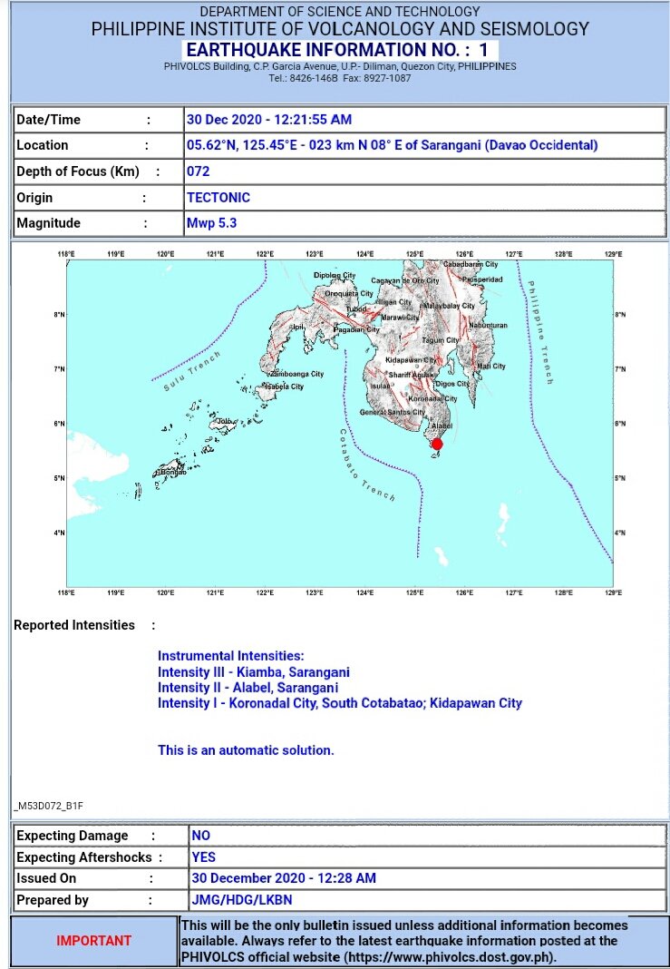
#Shaking detected
5.7MB #Magnitude #Earthquake reported
#Mindanao, #Philippines
#PhilippinesSea
60KM deep
2020/12/29| 16:21:50 UTC
GPS: 5.13, 125.52
reported by #emsc_Seismicportal
5.7MB #Magnitude #Earthquake reported
#Mindanao, #Philippines
#PhilippinesSea
60KM deep
2020/12/29| 16:21:50 UTC
GPS: 5.13, 125.52
reported by #emsc_Seismicportal

via @phivolcs_dost 
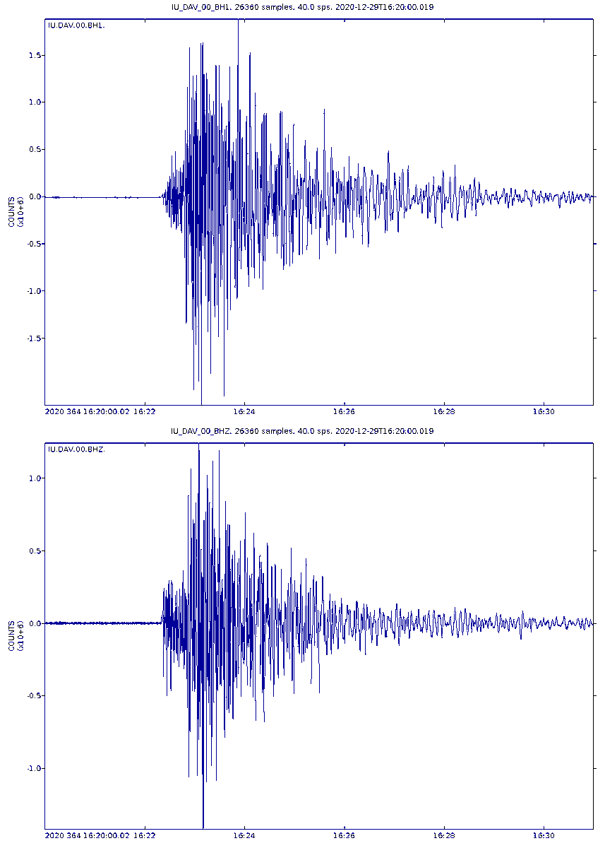
Data plotted by Seismograph
IU-DAV (#Davo, #Philippines)
for time range: 2020/12/29|
16:20:00 to 16:30:59 UTC
IU-DAV (#Davo, #Philippines)
for time range: 2020/12/29|
16:20:00 to 16:30:59 UTC
#Shaking detected
5.2MB #Magnitude #Earthquake reported
#Cepeliš (Grad Petrinja), Sisak-Moslavina #Croatia
2KM deep
2020/12/28| : 05:28:08UTC
GPS: 45.4, 16.24
reported by #emsc_Seismicportal
5.2MB #Magnitude #Earthquake reported
#Cepeliš (Grad Petrinja), Sisak-Moslavina #Croatia
2KM deep
2020/12/28| : 05:28:08UTC
GPS: 45.4, 16.24
reported by #emsc_Seismicportal

GKKI/GEOFON Station
#Piszkes,#Hungary
Code: GE-PSZ
Location: 47.92, 19.89
Elevation940 m
#Croatia #Earthquake
#Piszkes,#Hungary
Code: GE-PSZ
Location: 47.92, 19.89
Elevation940 m
#Croatia #Earthquake

#Shaking detected
5.3MW #Magnitude #Earthquake reported
Eastern Turkey, #Aşaği Huh, #Elaziğ, #Turkey
16KM deep
2020/12/27| 06:37:32 (UTC)
GPS: 38.49, 39.21
reported by #emsc_Seismicportal
5.3MW #Magnitude #Earthquake reported
Eastern Turkey, #Aşaği Huh, #Elaziğ, #Turkey
16KM deep
2020/12/27| 06:37:32 (UTC)
GPS: 38.49, 39.21
reported by #emsc_Seismicportal

According to @USGS
A 5.5MWW #Magnitude #Earthquake 8 km WNW of #Sivrice, #Turkey
10KM deep
GPS: 38.4688, 39.2206
A 5.5MWW #Magnitude #Earthquake 8 km WNW of #Sivrice, #Turkey
10KM deep
GPS: 38.4688, 39.2206
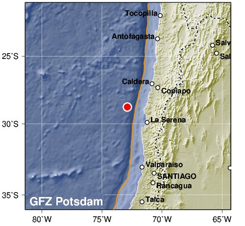
#Shaking detected
5.0M #Magnitude #Earthquake reported
Off coast of #Atacama desert, #Chile #SouthPacificOcean
10KM deep
2020/12/19| 10:38:53 (UTC)
GPS: -28.76, -72.95
reported by #emsc_Seismicportal
5.0M #Magnitude #Earthquake reported
Off coast of #Atacama desert, #Chile #SouthPacificOcean
10KM deep
2020/12/19| 10:38:53 (UTC)
GPS: -28.76, -72.95
reported by #emsc_Seismicportal

Another image by @GFZ_Potsdam there give GPS is btw the same 
Data plotted by Seismograph
C1-CO10 (Punta de Choros, #Chile)
GPS: -29.241, 71.461
for time range: 2020/12/19|
10:38:00 to 10:45:59 (UTC)
#Chile #Earthquake distance 122KM from Seismograph NW
C1-CO10 (Punta de Choros, #Chile)
GPS: -29.241, 71.461
for time range: 2020/12/19|
10:38:00 to 10:45:59 (UTC)
#Chile #Earthquake distance 122KM from Seismograph NW

#Shaking detected
5.6M #Magnitude #Earthquake reported
#Ribra, Departamento de Gracias a Dios, #Honduras
1KM deep
2020/12/15| 20:11:23 (UTC)
GPS: 15.23, -84.18
reported by #emsc_Seismicportal
5.6M #Magnitude #Earthquake reported
#Ribra, Departamento de Gracias a Dios, #Honduras
1KM deep
2020/12/15| 20:11:23 (UTC)
GPS: 15.23, -84.18
reported by #emsc_Seismicportal

GEOFON Station INETER, GEOFON Station #Boaco, #Nicaragua
Code: GE-BOAB
Location: 12.45, 85.67
Elevation: 381 m
#Honduras #Earthquake

Code: GE-BOAB
Location: 12.45, 85.67
Elevation: 381 m
#Honduras #Earthquake


Data plotted by Seismograph
NU-BILN (Z, #Nicaragua)
GPS: 14.049, -83.375
for time range: 2020/12/15|
20:10:00 to 20:20:59 (UTC)
#Honduras #Earthquake
NU-BILN (Z, #Nicaragua)
GPS: 14.049, -83.375
for time range: 2020/12/15|
20:10:00 to 20:20:59 (UTC)
#Honduras #Earthquake

#STRONG #SHAKING DETECTED
6.0MW #Magnitude #Earthquake reported.
#NorweiganSea, Norweigan sea
2KM deep
2020/12/14| 19:35:59 (UTC)
GPS: 72.25, 0.1
reported by #emsc_Seismicportal
NO TSUNAMI THREAT EXPECTED.
6.0MW #Magnitude #Earthquake reported.
#NorweiganSea, Norweigan sea
2KM deep
2020/12/14| 19:35:59 (UTC)
GPS: 72.25, 0.1
reported by #emsc_Seismicportal
NO TSUNAMI THREAT EXPECTED.

#Shaking detected
5.7MW #Magnitude #Earthquake reported
El Oio de San Pedro, Calama, (Provincia de El Loa), #Antofagasta, #Chile, 83KM deep
2020/12/14| 15:20:47 (UTC)
GPS: -21.82, -68.41
reported by #emsc_Seismicportal
5.7MW #Magnitude #Earthquake reported
El Oio de San Pedro, Calama, (Provincia de El Loa), #Antofagasta, #Chile, 83KM deep
2020/12/14| 15:20:47 (UTC)
GPS: -21.82, -68.41
reported by #emsc_Seismicportal

According to "Centro Sismólogico Nacional (CSN) (@Sismos_CSN)"
Locsl time: 2020/12/14 12:20:47
Place: 68 km al N de Calama
GPS: -21.880, -68.760
Depth: 117KM
Magnitude: 5.6 Mw
Locsl time: 2020/12/14 12:20:47
Place: 68 km al N de Calama
GPS: -21.880, -68.760
Depth: 117KM
Magnitude: 5.6 Mw

#Shaking detected
5.8MB #Magnitude #Earthquake reported
#Timor region, Sawu sea, #Indonesia
101KM deep
2020/12/12| 15:55:24 (UTC)
GPS: -9.16, 123.42
reported by #emsc_Seismicportal

5.8MB #Magnitude #Earthquake reported
#Timor region, Sawu sea, #Indonesia
101KM deep
2020/12/12| 15:55:24 (UTC)
GPS: -9.16, 123.42
reported by #emsc_Seismicportal


#Shaking detected
5.4MB #Magnitude #Earthquake reported
10 km S of #SalinaCruz, #Mexico
25.6KM deep
2020/12/08| 17:56:42 (UTC)
GPS: 16.079, 95.206
reported by @USGS
5.4MB #Magnitude #Earthquake reported
10 km S of #SalinaCruz, #Mexico
25.6KM deep
2020/12/08| 17:56:42 (UTC)
GPS: 16.079, 95.206
reported by @USGS

EARTHQUAKE Magnitude 5.5 Loc 64 km SOUTHWEST of SALINA CRUZ, OAX 12/08/20 11:56:41 Lat 15.65 Lon -95.41 Pf 53 km  via @SismologicoMX
 via @SismologicoMX
#Shaking detected
5.3MB #Magnitude #Earthquake reported
West of #Gibraltar, #UnitedKingdom , North Atlantic Ocean
60KM deep
2020/12/08| 16:35:44 (UTC)
GPS: 35.15, -9.33
reported by #emsc_Seismicportal
5.3MB #Magnitude #Earthquake reported
West of #Gibraltar, #UnitedKingdom , North Atlantic Ocean
60KM deep
2020/12/08| 16:35:44 (UTC)
GPS: 35.15, -9.33
reported by #emsc_Seismicportal

According to "Instituto Geográfico Nacional" its a 4.8mb #Magnitude #Earthquake 56KM deep.
SW of Cabo de san Vicente.
GPS: 35.0871, -9.3756
SW of Cabo de san Vicente.
GPS: 35.0871, -9.3756

#STRONG #SHAKING DETECTED
6.0MB #Magnitude #Earthquake reported
#Tarpaca, Guasco Lípez,Provinicia del Tamarugal, #Chile
80KM deep
2020/12/06| 16:47:41 UTC
GPS: -20.33, -68.86
reported by #emsc_Seismicportal
6.0MB #Magnitude #Earthquake reported
#Tarpaca, Guasco Lípez,Provinicia del Tamarugal, #Chile
80KM deep
2020/12/06| 16:47:41 UTC
GPS: -20.33, -68.86
reported by #emsc_Seismicportal

According to @GFZ_Potsdam its a 6.1 MW #Magnitude #Earthquake at the Chile-Bolivian border region. 86KM deep
GPS: -20.39, -68.92,
GPS: -20.39, -68.92,
Selected station
Limon Verde, #Chile
Code: GE-LVC
Location: -22.61 -,68.91
Elevation: 2960 m
#Chile #Earthquake
Limon Verde, #Chile
Code: GE-LVC
Location: -22.61 -,68.91
Elevation: 2960 m
#Chile #Earthquake


